|
|
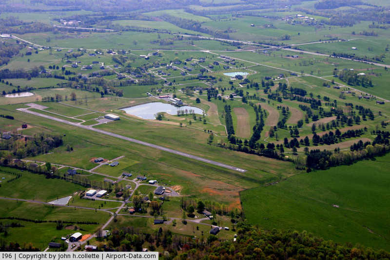
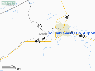
Columbia-Adair Company Airport |
|
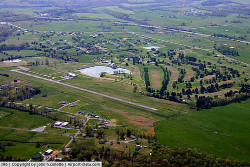 |
(Click on the photo to enlarge) |
|
Location &
QuickFacts
|
FAA
Information Effective: |
2008-09-25 |
|
Airport
Identifier: |
I96 |
|
Airport
Status: |
Operational |
|
Longitude/Latitude: |
085-20-49.8640W/37-05-07.2230N
-85.347184/37.085340 (Estimated) |
|
Elevation: |
818 ft / 249.33 m (Estimated) |
|
Land: |
40 acres |
|
From
nearest city: |
2 nautical miles SW of Columbia, KY |
|
Location: |
Adair County, KY |
|
Magnetic Variation: |
02W (1985) |
Owner & Manager
|
Ownership: |
Publicly owned |
|
Owner: |
Columbia-adair Co. Arpt Board |
|
Address: |
10-a Maple Tree
Columbia, KY 42728 |
|
Phone
number: |
270-250-3947
CHAIRMAN, COLUMBIA-ADAIR CO. ARPT BOARD -JOHN RAREY |
|
Manager: |
John Rarey |
|
Address: |
1021 Powell Road
Columbia, KY 42728 |
|
Phone number: |
270-250-3947 |
Airport
Operations and Facilities
|
Airport
Use: |
Open to public |
|
Wind
indicator: |
Yes |
|
Segmented Circle: |
Yes |
|
Control
Tower: |
No |
|
Lighting
Schedule: |
DUSK-DAWN
ACTVT MIRL RY 08/26 & SAVASI RY 26 - CTAF. |
|
Beacon
Color: |
Clear-Green (lighted land airport) |
|
Landing
fee charge: |
No |
|
Sectional chart: |
St Louis |
|
Region: |
ASO - Southern |
|
Boundary
ARTCC: |
ZID - Indianapolis |
|
Tie-in
FSS: |
LOU - Louisville |
|
FSS on
Airport: |
No |
|
FSS Toll
Free: |
1-800-WX-BRIEF |
|
NOTAMs
Facility: |
LOU (NOTAM-d service avaliable) |
Airport Communications
|
CTAF: |
122.800 |
|
Unicom: |
122.800 |
Airport Services
|
Fuel
available: |
100LL
24 HR CREDIT CARD SVC AVBL. |
|
Airframe
Repair: |
NONE |
|
Power
Plant Repair: |
NONE |
|
Bottled
Oxygen: |
NONE |
|
Bulk
Oxygen: |
NONE |
|
Runway Information
Runway 08/26
|
Dimension: |
2600 x 60 ft / 792.5 x 18.3 m |
|
Surface: |
ASPH, Good Condition |
|
Surface
Treatment: |
Aggregate Friction Seal Coat |
|
Weight Limit: |
Single wheel: 12000 lbs. |
|
Edge Lights: |
Medium |
|
|
Runway 08
|
Runway 26
|
|
Traffic
Pattern: |
Left |
Left |
|
Markings: |
Basic, Good Condition |
Basic, Good Condition |
|
Crossing
Height: |
0.00 ft |
31.00 ft |
|
VASI: |
|
2-box SAVASI on left side |
|
Visual
Glide Angle: |
0.00° |
4.00° |
|
Obstruction: |
44 ft trees, 1300.0 ft from runway, 25:1 slope to clear |
7 ft trees, 300.0 ft from runway, 100 ft right of
centerline, 14:1 slope to clear |
|
Radio Navigation Aids
|
ID |
Type |
Name |
Ch |
Freq |
Var |
Dist |
|
TYC |
NDB |
Taylor County |
|
272.00 |
02W |
19.7 nm |
|
EKQ |
NDB |
Elk Spring |
|
290.00 |
03W |
27.4 nm |
|
BVQ |
NDB |
Beaver Creek |
|
260.00 |
02W |
32.0 nm |
|
CDX |
NDB |
Cumberland River |
|
388.00 |
05E |
32.4 nm |
|
IKY |
NDB |
Springfield |
|
429.00 |
03W |
33.4 nm |
|
DVK |
NDB |
Goodall |
|
311.00 |
03W |
40.6 nm |
|
BRY |
NDB |
Bardstown/dcmsnd |
|
248.00 |
02W |
46.3 nm |
|
LFB |
NDB |
Lafayette |
|
245.00 |
02W |
48.5 nm |
|
EWO |
VOR/DME |
New Hope |
045X |
110.80 |
01E |
36.4 nm |
|
LVT |
VORTAC |
Livingston |
021X |
108.40 |
02W |
31.3 nm |
Remarks
-
VFR USE ONLY;
LUDOT ARPT IS CLOSED.
Based Aircraft
|
Aircraft based
on field: |
13 |
|
Single Engine
Airplanes: |
13 |
Operational Statistics
Time Period: 2006-09-21 - 2007-09-20
|
Aircraft
Operations: |
80/Week |
|
Air Taxi: |
7.2% |
|
General
Aviation Local: |
44.6% |
|
General
Aviation Itinerant: |
45.8% |
|
Military: |
2.4% |
Columbia-adair Company
Airport
Address:
Adair County, KY
Tel:
270-250-3947
Images
and information placed above are from
http://www.airport-data.com/airport/I96/
We
thank them for the data!
|
General Info |
| Country |
United
States |
| State |
KENTUCKY
|
| FAA ID |
I96
|
| Latitude |
37-05-07.223N |
|
Longitude |
085-20-49.864W |
|
Elevation |
818 feet
|
| Near
City |
COLUMBIA
|
We don't guarantee the information is fresh and accurate. The data may
be wrong or outdated.
For more up-to-date information please refer to other sources.
|
|