 |
|
|
Location &
QuickFacts
|
FAA
Information Effective: |
2008-09-25 |
|
Airport
Identifier: |
22KY |
|
Airport
Status: |
Operational |
|
Longitude/Latitude: |
085-46-10.8640W/38-12-10.2530N
-85.769684/38.202848 (Estimated) |
|
Elevation: |
455 ft / 138.68 m (Estimated) |
|
Land: |
0 acres |
|
From
nearest city: |
0 nautical miles N of Louisville, KY |
|
Location: |
Jefferson County, KY |
|
Magnetic Variation: |
02W (1985) |
Owner & Manager
|
Ownership: |
Privately owned |
|
Owner: |
Churchill Downs Inc |
|
Address: |
700 Central Ave
Louisville, KY 40208 |
|
Phone number: |
502-636-4400 |
|
Manager: |
Dan Parkerson |
|
Address: |
700 Central Ave
Louisville, KY 40208 |
|
Phone number: |
502-636-4400 |
Airport
Operations and Facilities
|
Airport
Use: |
Private |
|
Segmented Circle: |
No |
|
Control
Tower: |
No |
|
Sectional chart: |
St Louis |
|
Region: |
ASO - Southern |
|
Boundary
ARTCC: |
ZID - Indianapolis |
|
Tie-in
FSS: |
LOU - Louisville |
|
FSS Toll
Free: |
1-800-WX-BRIEF |
|
Runway Information
Helipad H1
|
Dimension: |
250 x 125 ft / 76.2 x 38.1 m |
|
Surface: |
BRICK, |
|
|
Runway H1
|
Runway
|
|
Traffic
Pattern: |
Left |
Left |
|
Radio Navigation Aids
|
ID |
Type |
Name |
Ch |
Freq |
Var |
Dist |
|
GOI |
NDB |
Godman |
|
396.00 |
02W |
17.6 nm |
|
BRY |
NDB |
Bardstown/dcmsnd |
|
248.00 |
02W |
25.3 nm |
|
IMS |
NDB |
Madison |
|
404.00 |
03W |
36.6 nm |
|
RRJ |
NDB |
Oranj |
|
368.00 |
02W |
40.7 nm |
|
EQZ |
NDB |
Captain |
|
308.00 |
02W |
41.1 nm |
|
IKY |
NDB |
Springfield |
|
429.00 |
03W |
42.5 nm |
|
FEU |
NDB |
Arnold |
|
521.00 |
03W |
44.9 nm |
|
TEL |
NDB |
Tell City |
|
206.00 |
02W |
45.0 nm |
|
BFR |
NDB |
Bedford |
|
344.00 |
02W |
49.5 nm |
|
MYS |
VOR |
Mystic |
|
108.20 |
01W |
29.1 nm |
|
FFT |
VOR |
Frankfort |
|
109.40 |
03W |
40.7 nm |
|
BQM |
VOR/DME |
Bowman |
059X |
112.20 |
01W |
5.2 nm |
|
FTK |
VOR/DME |
Fort Knox |
033X |
109.60 |
01W |
20.2 nm |
|
EWO |
VOR/DME |
New Hope |
045X |
110.80 |
01E |
34.6 nm |
|
IIU |
VORTAC |
Louisville |
095X |
114.80 |
01E |
10.9 nm |
|
ABB |
VORTAC |
Nabb |
071X |
112.40 |
01E |
24.0 nm |
|
SDF |
VOT |
Louisville Standifd |
|
111.00 |
|
2.2 nm |
Remarks
-
PRVDD VFR/PVT
USE; & COMMUNICATIONS ESTABLISHED W/STANDIFORD FIELD ATC PRIOR TO TKOFF/LDG.
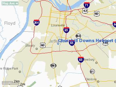
Churchill Downs Heliport
Address:
Jefferson County, KY
Tel:
502-636-4400
Images
and information placed above are from
http://www.airport-data.com/airport/22KY/
We
thank them for the data!
|
General Info |
| Country |
United
States |
| State |
KENTUCKY
|
| FAA ID |
22KY
|
| Latitude |
38-12-10.253N |
|
Longitude |
085-46-10.864W |
|
Elevation |
455 feet
|
| Near
City |
LOUISVILLE |
We don't guarantee the information is fresh and accurate. The data may
be wrong or outdated.
For more up-to-date information please refer to other sources.
|
|


