 |
|
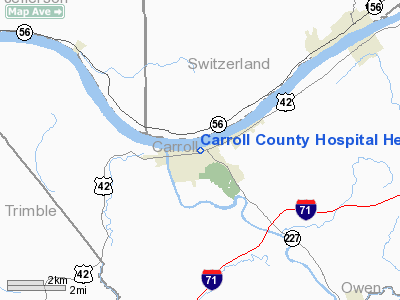
Carroll County Hospital Heliport |
|
|
|
Location &
QuickFacts
|
FAA
Information Effective: |
2008-09-25 |
|
Airport
Identifier: |
3KY5 |
|
Airport
Status: |
Operational |
|
Longitude/Latitude: |
085-10-00.0000W/38-41-00.0000N
-85.166667/38.683333 (Estimated) |
|
Elevation: |
480 ft / 146.30 m (Estimated) |
|
Land: |
30 acres |
|
From
nearest city: |
2 nautical miles NE of Carrollton, KY |
|
Location: |
Carroll County, KY |
|
Magnetic Variation: |
03W () |
Owner & Manager
|
Ownership: |
Privately owned |
|
Owner: |
Carroll County Hospital |
|
Address: |
309 Eleventh Street
Carrollton, KY 41008 |
|
Phone
number: |
502-732-4321 |
|
Manager: |
Roger Williams
CARROLL COUNTY HOSPITAL C.E.O. |
|
Address: |
309 Eleventh Street
Carrollton, KY 41008 |
|
Phone number: |
502-732-4321 |
Airport
Operations and Facilities
|
Airport
Use: |
Private |
|
Wind
indicator: |
Yes |
|
Segmented Circle: |
No |
|
Control
Tower: |
No |
|
Lighting
Schedule: |
DUSK-DAWN |
|
Beacon
Color: |
Clear-Green-Yellow (heliport) |
|
Sectional chart: |
St Louis |
|
Region: |
ASO - Southern |
|
Boundary
ARTCC: |
ZID - Indianapolis |
|
Tie-in
FSS: |
LOU - Louisville |
|
FSS Toll
Free: |
1-800-WX-BRIEF |
|
Runway Information
Helipad H1
|
Dimension: |
50 x 50 ft / 15.2 x 15.2 m |
|
Surface: |
CONC, |
|
|
Runway H1
|
Runway
|
|
Traffic
Pattern: |
Left |
Left |
|
Radio Navigation Aids
|
ID |
Type |
Name |
Ch |
Freq |
Var |
Dist |
|
IMS |
NDB |
Madison |
|
404.00 |
03W |
14.5 nm |
|
UR |
NDB |
Burln |
|
321.00 |
04W |
28.5 nm |
|
OVO |
NDB |
North Vernon |
|
374.00 |
02W |
30.0 nm |
|
FEU |
NDB |
Arnold |
|
521.00 |
03W |
32.6 nm |
|
EQZ |
NDB |
Captain |
|
308.00 |
02W |
39.4 nm |
|
HLB |
NDB |
Batesville |
|
254.00 |
02W |
40.3 nm |
|
LUK |
NDB |
Cincinnati |
|
335.00 |
04W |
48.1 nm |
|
LE |
NDB |
Blayd |
|
242.00 |
04W |
48.2 nm |
|
BA |
NDB |
Clifs |
|
410.00 |
03W |
49.0 nm |
|
ISZ |
NDB |
Cincinnati-blue Ash |
|
388.00 |
04W |
49.7 nm |
|
HAO |
NDB |
Hamilton |
|
260.00 |
04W |
49.9 nm |
|
MDE |
NDB |
Madeira |
|
379.00 |
04W |
49.9 nm |
|
FFT |
VOR |
Frankfort |
|
109.40 |
03W |
32.5 nm |
|
BQM |
VOR/DME |
Bowman |
059X |
112.20 |
01W |
35.9 nm |
|
FLM |
VOR/DME |
Falmouth |
117X |
117.00 |
04W |
40.2 nm |
|
ABB |
VORTAC |
Nabb |
071X |
112.40 |
01E |
22.8 nm |
|
CVG |
VORTAC |
Cincinnati |
120X |
117.30 |
04W |
29.5 nm |
|
IIU |
VORTAC |
Louisville |
095X |
114.80 |
01E |
39.9 nm |
|
SDF |
VOT |
Louisville Standifd |
|
111.00 |
|
40.5 nm |
|
LUK |
VOT |
Cincinnati Muni/lunken |
|
108.40 |
|
44.3 nm |
Remarks
-
20 FT LGTD POLE
52 FT FROM HELIPAD.
-
PRVDD APCH/DEP
OPNS FROM 020 TO 050 DEGS CLKWS, AREA IS MKD, WIND INDICATOR IS MAINTAINED, BE
ADVISED ON MTR IN VICINITY OF HELIPORT.
Carroll County Hospital Heliport
Address:
Carroll County, KY
Tel:
502-732-4321
Images
and information placed above are from
http://www.airport-data.com/airport/3KY5/
We
thank them for the data!
|
General Info |
| Country |
United
States |
| State |
KENTUCKY
|
| FAA ID |
3KY5
|
| Latitude |
38-41-00.000N |
|
Longitude |
085-10-00.000W |
|
Elevation |
480 feet
|
| Near
City |
CARROLLTON |
We don't guarantee the information is fresh and accurate. The data may
be wrong or outdated.
For more up-to-date information please refer to other sources.
|
|


