 |
|
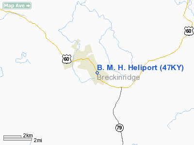
Breckinridge Memorial Hospital Heliport |
|
|
|
Location &
QuickFacts
|
FAA
Information Effective: |
2008-09-25 |
|
Airport
Identifier: |
47KY |
|
Airport
Status: |
Operational |
|
Longitude/Latitude: |
086-26-27.9190W/37-46-00.2130N
-86.441089/37.766726 (Estimated) |
|
Elevation: |
730 ft / 222.50 m (Estimated) |
|
Land: |
0 acres |
|
From
nearest city: |
1 nautical miles SE of Hardinsburg, KY |
|
Location: |
Breckinridge County, KY |
|
Magnetic Variation: |
01W (1985) |
Owner & Manager
|
Ownership: |
Privately owned |
|
Owner: |
Breckinridge Memorial Hosp |
|
Address: |
1011 Old Highway 60
Hardinsburg, KY 40143-9732 |
|
Phone number: |
502-756-2124 |
|
Manager: |
Breckinridge Memorial Hosp |
|
Address: |
1011 Old Highway 60
Hardinsburg, KY 40143-9732 |
|
Phone number: |
502-756-2124 |
Airport
Operations and Facilities
|
Airport
Use: |
Private
MEDICAL. |
|
Wind
indicator: |
Yes |
|
Segmented Circle: |
No |
|
Control
Tower: |
No |
|
Lighting
Schedule: |
PHONE REQ
FOR ROTG BCN CALL 502-756-2124. |
|
Beacon
Color: |
Clear-Green-Yellow (heliport) |
|
Sectional chart: |
St Louis |
|
Region: |
ASO - Southern |
|
Boundary
ARTCC: |
ZID - Indianapolis |
|
Tie-in
FSS: |
LOU - Louisville |
|
FSS on
Airport: |
No |
|
FSS Toll
Free: |
1-800-WX-BRIEF |
|
Runway Information
Helipad H1
|
Dimension: |
75 x 75 ft / 22.9 x 22.9 m |
|
Surface: |
CONC, |
|
|
Runway H1
|
Runway
|
|
Traffic
Pattern: |
Left |
Left |
|
Radio Navigation Aids
|
ID |
Type |
Name |
Ch |
Freq |
Var |
Dist |
|
TEL |
NDB |
Tell City |
|
206.00 |
02W |
19.0 nm |
|
GOI |
NDB |
Godman |
|
396.00 |
02W |
24.9 nm |
|
FNZ |
NDB |
Ferdinand |
|
239.00 |
00E |
34.5 nm |
|
BRY |
NDB |
Bardstown/dcmsnd |
|
248.00 |
02W |
45.8 nm |
|
RRJ |
NDB |
Oranj |
|
368.00 |
02W |
45.9 nm |
|
GMH |
NDB |
Muhlenberg |
|
362.00 |
01E |
47.2 nm |
|
BVQ |
NDB |
Beaver Creek |
|
260.00 |
02W |
49.5 nm |
|
MYS |
VOR |
Mystic |
|
108.20 |
01W |
12.1 nm |
|
FTK |
VOR/DME |
Fort Knox |
033X |
109.60 |
01W |
23.8 nm |
|
OWB |
VOR/DME |
Owensboro |
023X |
108.60 |
01E |
34.5 nm |
|
EWO |
VOR/DME |
New Hope |
045X |
110.80 |
01E |
37.3 nm |
|
HNB |
VOR/DME |
Huntingburg |
029X |
109.20 |
00E |
38.0 nm |
|
BQM |
VOR/DME |
Bowman |
059X |
112.20 |
01W |
46.1 nm |
|
CCT |
VORTAC |
Central City |
035X |
109.80 |
01W |
45.5 nm |
|
IIU |
VORTAC |
Louisville |
095X |
114.80 |
01E |
45.7 nm |
|
SDF |
VOT |
Louisville Standifd |
|
111.00 |
|
41.5 nm |
Remarks
-
PRVDD ALL OPNS
CONTINUE TO BE CONDUCTED IN VFR WEATHER CONDS; PVT USE; APCH/DEP OPNS
CONDUCTED FM 110 DEGS CLOCKWISE TO 180 DEGS; TKOF/LNDG AREA MKD; WIND
INDICATOR MAINTAINED.
Based Aircraft
|
Aircraft based
on field: |
1 |
|
Helicopters: |
1 |
Breckinridge Memorial Hospital Heliport
Address:
Breckinridge County, KY
Tel:
502-756-2124
Images
and information placed above are from
http://www.airport-data.com/airport/47KY/
We
thank them for the data!
|
General Info |
| Country |
United
States |
| State |
KENTUCKY
|
| FAA ID |
47KY
|
| Latitude |
37-46-00.213N |
|
Longitude |
086-26-27.919W |
|
Elevation |
730 feet
|
| Near
City |
HARDINSBURG |
We don't guarantee the information is fresh and accurate. The data may
be wrong or outdated.
For more up-to-date information please refer to other sources.
|
|


