 |
|
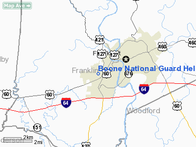
Boone National Guard Heliport |
|
|
|
Location &
QuickFacts
|
FAA
Information Effective: |
2008-09-25 |
|
Airport
Identifier: |
02KY |
|
Airport
Status: |
Operational |
|
Longitude/Latitude: |
084-53-59.8220W/38-11-00.2600N
-84.899951/38.183406 (Estimated) |
|
Elevation: |
760 ft / 231.65 m (Estimated) |
|
Land: |
0 acres |
|
From
nearest city: |
0 nautical miles W of Frankfort, KY |
|
Location: |
Franklin County, KY |
|
Magnetic Variation: |
03W (1985) |
Owner & Manager
|
Ownership: |
Publicly owned |
|
Owner: |
Ky Army National Guard |
|
Address: |
Boone Nat Guard Center
Frankfort, KY 40601-6168 |
|
Phone
number: |
502-564-8471 |
|
Manager: |
Col Thomas M Quisenberry |
|
Address: |
Boone Army Nat Guard Center
Frankfort, KY 40601-6168 |
|
Phone number: |
502-564-8471
EXT. 471. |
Airport Operations and Facilities
|
Airport
Use: |
Private |
|
Wind
indicator: |
Yes |
|
Segmented Circle: |
No |
|
Control
Tower: |
No |
|
Lighting
Schedule: |
DUSK-DAWN |
|
Beacon
Color: |
Clear-Green (lighted land airport) |
|
Landing fee charge: |
No |
|
Sectional chart: |
Cincinnati |
|
Region: |
ASO - Southern |
|
Boundary ARTCC: |
ZID - Indianapolis |
|
Tie-in FSS: |
LOU - Louisville |
|
FSS on Airport: |
No |
|
FSS Toll Free: |
1-800-WX-BRIEF |
Airport
Communications
|
Runway Information
Helipad H1
|
Dimension: |
100 x 100 ft / 30.5 x 30.5 m |
|
Surface: |
CONC, |
|
|
Runway H1
|
Runway
|
|
Traffic
Pattern: |
Left |
Left |
|
Radio Navigation Aids
|
ID |
Type |
Name |
Ch |
Freq |
Var |
Dist |
|
FEU |
NDB |
Arnold |
|
521.00 |
03W |
4.2 nm |
|
LE |
NDB |
Blayd |
|
242.00 |
04W |
16.4 nm |
|
BRY |
NDB |
Bardstown/dcmsnd |
|
248.00 |
02W |
34.2 nm |
|
IKY |
NDB |
Springfield |
|
429.00 |
03W |
36.6 nm |
|
DVK |
NDB |
Goodall |
|
311.00 |
03W |
37.0 nm |
|
IMS |
NDB |
Madison |
|
404.00 |
03W |
43.6 nm |
|
IOB |
NDB |
Mount Sterling |
|
210.00 |
04W |
44.1 nm |
|
XYC |
NDB |
Seco |
|
393.00 |
03W |
48.5 nm |
|
TYC |
NDB |
Taylor County |
|
272.00 |
02W |
49.7 nm |
|
FFT |
VOR |
Frankfort |
|
109.40 |
03W |
0.4 nm |
|
BQM |
VOR/DME |
Bowman |
059X |
112.20 |
01W |
36.2 nm |
|
FLM |
VOR/DME |
Falmouth |
117X |
117.00 |
04W |
39.4 nm |
|
EWO |
VOR/DME |
New Hope |
045X |
110.80 |
01E |
49.5 nm |
|
HYK |
VORTAC |
Lexington |
073X |
112.60 |
00E |
24.1 nm |
|
IIU |
VORTAC |
Louisville |
095X |
114.80 |
01E |
32.4 nm |
|
ABB |
VORTAC |
Nabb |
071X |
112.40 |
01E |
42.4 nm |
|
SDF |
VOT |
Louisville Standifd |
|
111.00 |
|
39.5 nm |
Remarks
-
NATIONAL GUARD
OPNL FREQ 139.35 UHF 226.6 FM 41.15.
-
VFR ONLY; PVT
USE; COORD USE WITH LOUISVILLE GADO.
Based Aircraft
|
Aircraft based
on field: |
31 |
|
Multi Engine
Airplanes: |
1 |
|
Helicopters: |
30 |
Boone National Guard Heliport
Address:
Franklin County, KY
Tel:
502-564-8471
Images
and information placed above are from
http://www.airport-data.com/airport/02KY/
We
thank them for the data!
|
General Info |
| Country |
United
States |
| State |
KENTUCKY
|
| FAA ID |
02KY
|
| Latitude |
38-11-00.260N |
|
Longitude |
084-53-59.822W |
|
Elevation |
760 feet
|
| Near
City |
FRANKFORT |
We don't guarantee the information is fresh and accurate. The data may
be wrong or outdated.
For more up-to-date information please refer to other sources.
|
|


