 |
|
|
|
|
|
|
Location &
QuickFacts
|
FAA
Information Effective: |
2008-09-25 |
|
Airport
Identifier: |
07KY |
|
Airport
Status: |
Operational |
|
Longitude/Latitude: |
085-41-35.8530W/38-04-50.2410N
-85.693292/38.080623 (Estimated) |
|
Elevation: |
532 ft / 162.15 m (Surveyed) |
|
Land: |
12 acres |
|
From
nearest city: |
9 nautical miles SE of Louisville, KY |
|
Location: |
Bullitt County, KY |
|
Magnetic Variation: |
02W (1985) |
Owner & Manager
|
Ownership: |
Privately owned |
|
Owner: |
Thomas H. Jean |
|
Address: |
1432 Hillview Blvd
Hillview, KY 40229
ARPT RELATED CORRESPONDENCE TO ARPT MGR ONLY. |
|
Phone number: |
502-957-5159 |
|
Manager: |
Thomas H. Jean |
|
Address: |
1432 Hillview Blvd
Hillview, KY 40229 |
|
Phone number: |
502-957-5159 |
Airport Operations and Facilities
|
Airport Use: |
Private |
|
Wind indicator: |
Yes |
|
Segmented Circle: |
Yes |
|
Control Tower: |
No |
|
Landing fee charge: |
No |
|
Sectional chart: |
St Louis |
|
Region: |
ASO - Southern |
|
Boundary ARTCC: |
ZID - Indianapolis |
|
Tie-in FSS: |
LOU - Louisville |
|
FSS on Airport: |
No |
|
FSS Toll Free: |
1-800-WX-BRIEF |
Airport
Communications
Airport Services
|
Airframe
Repair: |
NONE |
|
Power
Plant Repair: |
NONE |
|
Bottled
Oxygen: |
NONE |
|
Bulk
Oxygen: |
NONE |
|
Runway Information
Runway 11/29
|
Dimension: |
2000 x 100 ft / 609.6 x 30.5 m |
|
Surface: |
TURF, |
|
|
Runway 11
|
Runway 29
|
|
Traffic
Pattern: |
Right |
Left |
|
Markings: |
Nonstandard, Good Condition |
Nonstandard, Good Condition |
|
Radio Navigation Aids
|
ID |
Type |
Name |
Ch |
Freq |
Var |
Dist |
|
GOI |
NDB |
Godman |
|
396.00 |
02W |
15.3 nm |
|
BRY |
NDB |
Bardstown/dcmsnd |
|
248.00 |
02W |
17.2 nm |
|
IKY |
NDB |
Springfield |
|
429.00 |
03W |
34.5 nm |
|
FEU |
NDB |
Arnold |
|
521.00 |
03W |
42.1 nm |
|
IMS |
NDB |
Madison |
|
404.00 |
03W |
42.3 nm |
|
TYC |
NDB |
Taylor County |
|
272.00 |
02W |
46.1 nm |
|
TEL |
NDB |
Tell City |
|
206.00 |
02W |
47.4 nm |
|
RRJ |
NDB |
Oranj |
|
368.00 |
02W |
47.7 nm |
|
EQZ |
NDB |
Captain |
|
308.00 |
02W |
49.1 nm |
|
LE |
NDB |
Blayd |
|
242.00 |
04W |
49.2 nm |
|
MYS |
VOR |
Mystic |
|
108.20 |
01W |
28.4 nm |
|
FFT |
VOR |
Frankfort |
|
109.40 |
03W |
37.6 nm |
|
BQM |
VOR/DME |
Bowman |
059X |
112.20 |
01W |
9.1 nm |
|
FTK |
VOR/DME |
Fort Knox |
033X |
109.60 |
01W |
16.8 nm |
|
EWO |
VOR/DME |
New Hope |
045X |
110.80 |
01E |
27.0 nm |
|
IIU |
VORTAC |
Louisville |
095X |
114.80 |
01E |
5.7 nm |
|
ABB |
VORTAC |
Nabb |
071X |
112.40 |
01E |
30.7 nm |
|
SDF |
VOT |
Louisville Standifd |
|
111.00 |
|
6.2 nm |
Remarks
-
LIMITED TO 15
BASED ACFT VFR OPS ONLY. MGR COORDINATES INGRESS/EGRESS WITH STANDIFORD FIELD
TWR.
Based Aircraft
|
Aircraft based
on field: |
15 |
|
Single Engine
Airplanes: |
15 |
Operational Statistics
Time Period: 1978-12-15 - 1979-12-14
|
Aircraft
Operations: |
24/Week |
|
General
Aviation Local: |
97.6% |
|
General
Aviation Itinerant: |
2.4% |
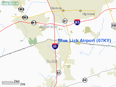
Blue Lick Airport
Address:
Bullitt County, KY
Tel:
502-957-5159
Images
and information placed above are from
http://www.airport-data.com/airport/07KY/
We
thank them for the data!
|
General Info |
| Country |
United
States |
| State |
KENTUCKY
|
| FAA ID |
07KY
|
| Latitude |
38-04-50.241N |
|
Longitude |
085-41-35.853W |
|
Elevation |
532 feet
|
| Near
City |
LOUISVILLE |
We don't guarantee the information is fresh and accurate. The data may
be wrong or outdated.
For more up-to-date information please refer to other sources.
|
|


