 |
|
|
Location &
QuickFacts
|
FAA
Information Effective: |
2008-09-25 |
|
Airport
Identifier: |
14KY |
|
Airport
Status: |
Operational |
|
Longitude/Latitude: |
084-22-05.7660W/38-10-25.2740N
-84.368268/38.173687 (Estimated) |
|
Elevation: |
985 ft / 300.23 m (Estimated) |
|
Land: |
0 acres |
|
From
nearest city: |
6 nautical miles SW of Paris, KY |
|
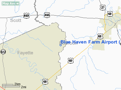
Location: |
Fayette County, KY |
|
Magnetic Variation: |
03W (1985) |
Owner & Manager
|
Ownership: |
Privately owned |
|
Owner: |
Robert Herren |
|
Address: |
Rt 9, Ferguson Road
Lexington, KY 40511 |
|
Phone
number: |
606-299-4850 |
|
Manager: |
Robert Herren |
|
Address: |
Rt 9, Ferguson Road
Lexington, KY 40511 |
|
Phone number: |
606-299-4850 |
Airport Operations and Facilities
|
Airport Use: |
Private |
|
Wind indicator: |
No |
|
Segmented Circle: |
No |
|
Control Tower: |
No |
|
Landing fee charge: |
Yes |
|
Sectional chart: |
Cincinnati |
|
Region: |
ASO - Southern |
|
Boundary ARTCC: |
ZID - Indianapolis |
|
Tie-in FSS: |
LOU - Louisville |
|
FSS on Airport: |
No |
|
FSS Toll Free: |
1-800-WX-BRIEF |
Airport Services
|
Airframe
Repair: |
NONE |
|
Power
Plant Repair: |
NONE |
|
Runway Information
Runway 13/31
|
Dimension: |
2240 x 75 ft / 682.8 x 22.9 m |
|
Surface: |
TURF, |
|
|
Runway 13
|
Runway 31
|
|
Traffic
Pattern: |
Left |
Left |
|
Radio Navigation Aids
|
ID |
Type |
Name |
Ch |
Freq |
Var |
Dist |
|
LE |
NDB |
Blayd |
|
242.00 |
04W |
17.8 nm |
|
IOB |
NDB |
Mount Sterling |
|
210.00 |
04W |
19.5 nm |
|
FEU |
NDB |
Arnold |
|
521.00 |
03W |
21.5 nm |
|
XYC |
NDB |
Seco |
|
393.00 |
03W |
29.7 nm |
|
DVK |
NDB |
Goodall |
|
311.00 |
03W |
40.5 nm |
|
XW |
NDB |
Flmng |
|
400.00 |
05W |
41.6 nm |
|
FFT |
VOR |
Frankfort |
|
109.40 |
03W |
25.5 nm |
|
FLM |
VOR/DME |
Falmouth |
117X |
117.00 |
04W |
28.7 nm |
|
HYK |
VORTAC |
Lexington |
073X |
112.60 |
00E |
13.4 nm |
Remarks
Blue Haven Farm Airport
Address:
Fayette County, KY
Tel:
606-299-4850
Images
and information placed above are from
http://www.airport-data.com/airport/14KY/
We
thank them for the data!
|
General Info |
| Country |
United
States |
| State |
KENTUCKY
|
| FAA ID |
14KY
|
| Latitude |
38-10-25.274N |
|
Longitude |
084-22-05.766W |
|
Elevation |
985 feet
|
| Near
City |
PARIS
|
We don't guarantee the information is fresh and accurate. The data may
be wrong or outdated.
For more up-to-date information please refer to other sources.
|
|


