|
|
| Blue Grass Airport |
 |
 |
| IATA: LEX â ICAO: KLEX â FAA LID: LEX
Location of Bluegrass Airport
|
| Summary |
| Airport type |
Public |
| Operator |
Lexington-Fayette County Airport Board |
| Serves |
Lexington, Kentucky |
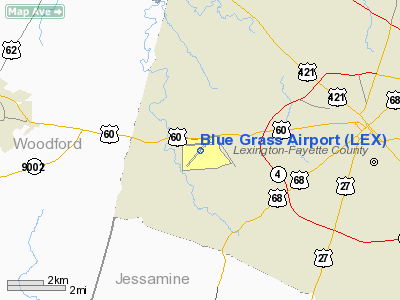
| Location |
Fayette County |
| Elevation AMSL |
979 ft / 298 m |
| Coordinates |
38°02â²11â³N 084°36â²21â³W / 38.03639°N 84.60583°W / 38.03639; -84.60583 |
| Website |
www.bluegrassairport.com |
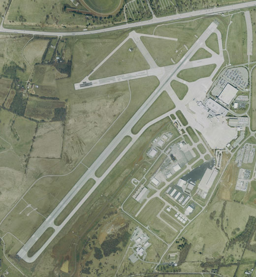
| Runways |
| Direction |
Length |
Surface |
| ft |
m |
| 4/22 |
7,003 |
2,135 |
Asphalt |
| 9/27 |
4,000 |
1,219 |
Concrete |
| Statistics (2009) |
| Aircraft operations |
67,370 |
| Based aircraft |
140 |
Blue Grass Airport (IATA: LEX, ICAO: KLEX, FAA LID: LEX) is a public airport located in Fayette County, Kentucky, United States, 4 miles west of the central business district of the City of Lexington. The main terminal building was opened in 1977. The airport covers an area of 911 acres (3.69 km) and has two runways. It is also home to the Aviation Museum of Kentucky. On April 18, 2007, Blue Grass Airport opened up an extension of Concourse B. The extension added six new boarding gates with 4 new jetways. In 2008 there were 1,007,225 passengers that either departed or arrived at Bluegrass Airport. Airlines and destinations
| Airlines |
Destinations |
Concourse |
| AirTran Airways |
Ft. Lauderdale [seasonal], Orlando |
B |
| Allegiant Air |
Orlando, Punta Gorda [begins November 18], St. Petersburg/Clearwater |
B |
| American Eagle |
Chicago-O'Hare, Dallas/Fort Worth |
A |
| Continental Express operated by ExpressJet Airlines |
Houston-Intercontinental |
B |
| Delta Air Lines |
Atlanta [seasonal], Detroit [seasonal] |
B |
| Delta Connection operated by Atlantic Southeast Airlines |
Atlanta, Memphis |
B |
| Delta Connection operated by Comair |
Cincinnati/Northern Kentucky [ends October 31], Detroit, Minneapolis/St. Paul, New York-LaGuardia, Memphis, Washington-Reagan |
B |
| Delta Connection operated by Mesaba Airlines |
Detroit, Memphis |
B |
| Delta Connection operated by Pinnacle Airlines |
Detroit, New York-LaGuardia, Memphis, Minneapolis/St. Paul, Washington-Reagan |
B |
| Delta Connection operated by SkyWest Airlines |
Minneapolis/St. Paul [begins November 1] |
B |
| United Express operated by SkyWest Airlines |
Chicago-O'Hare |
A |
| United Express operated by ExpressJet Airlines |
Chicago-O'Hare |
A |
| US Airways Express operated by Air Wisconsin |
Charlotte, New York-LaGuardia [begins October 31] |
A |
| US Airways Express operated by PSA Airlines |
Charlotte |
A |
Incidents and Accidents
- December 5, 1987: After suffering an in-flight engine fire en route from Dallas, Texas to New York, the flight crew of a Hawker Siddeley HS.125 business jet, registration number N400PH, touched down short of the runway while attempting an emergency landing at Blue Grass Airport. The jet crossed a highway and struck an automobile, utility poles, and 2 fences, killing the pilot and co-pilot, and injuring both passengers in the aircraft and 2 people in the automobile. The accident was attributed to the crew's inadvertent retraction of the aircraft's flaps, causing the jet to suddenly lose altitude.
- November 1993: The flight crew of an unidentified commercial jet at Blue Grass Airport was cleared for takeoff on Runway 22 but mistakenly lined up at the shorter Runway 26 instead. Tower personnel noticed the mistake and cancelled the aircraft's takeoff clearance just as the crew realized their error. The aircraft subsequently made a safe departure from Runway 22.
- August 30, 2002: A Learjet 35C, registration number N45CP, overran Runway 4 on landing, killing 1 passenger and seriously injuring 4 other occupants of the aircraft. The accident was attributed to the pilot's application of additional forward thrust after failing to properly deploy the jet's thrust reversers.
- August 27, 2006: Comair Flight 191, a Bombardier CRJ-100ER operated by regional carrier Comair on behalf of Delta Connection, overran Runway 26 and crashed after being cleared to take off from the much longer Runway 22. There were 49 fatalities, with the first officer, James Polehinke, being the only survivor.
- March 25, 2009: A Cessna 182, registration number N4871N, crashed 3 mi (5 km) west of Blue Grass Airport, killing the pilot and sole occupant. The pilot apparently became disoriented during the landing approach after losing electrical power in densely clouded IFR conditions, but the cause of the crash had not been positively determined as of September 2009.
Fictional Reference
Blue Grass Field was Auric Goldfinger's flight destination in the James Bond film Goldfinger
The above content comes from Wikipedia and is published under free licenses – click here to read more.
|
 |
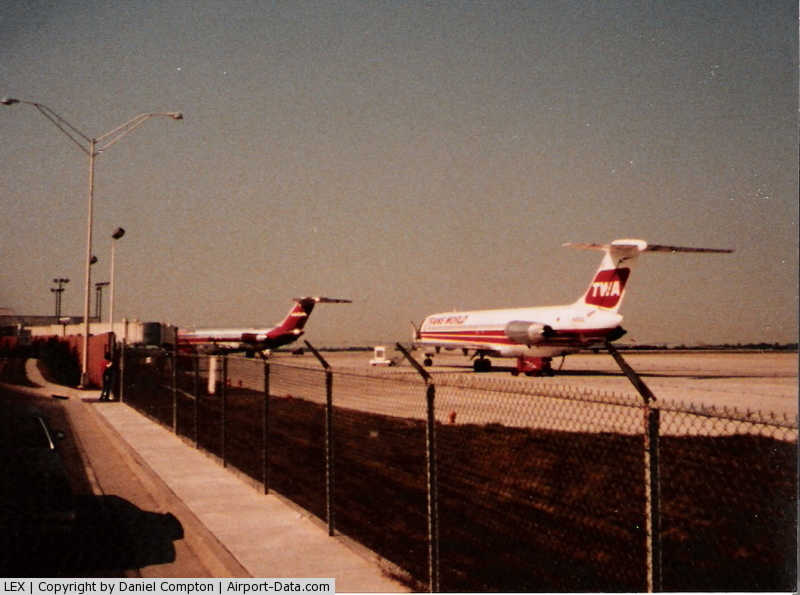
(Click on the photo to enlarge) |
|
Location &
QuickFacts
|
FAA
Information Effective: |
2008-09-25 |
|
Airport
Identifier: |
LEX |
|
Airport
Status: |
Operational |
|
Longitude/Latitude: |
084-36-21.2000W/38-02-11.4000N
-84.605889/38.036500 (Estimated) |
|
Elevation: |
979 ft / 298.40 m (Surveyed) |
|
Land: |
911 acres |
|
From
nearest city: |
4 nautical miles W of Lexington, KY |
|
Location: |
Fayette County, KY |
|
Magnetic Variation: |
04W (1995) |
Owner & Manager
|
Ownership: |
Publicly owned |
|
Owner: |
Lexington-fayette Co Arpt Brd |
|
Address: |
4000 Terminal Drive, Suite 206
Lexington, KY 40510 |
|
Phone
number: |
859-425-3100 |
|
Manager: |
Michael A. Gobb |
|
Address: |
4000 Terminal Drive, Suite 206
Lexington, KY 40510 |
|
Phone number: |
859-425-3100 |
Airport Operations and Facilities
|
Airport
Use: |
Open to public |
|
Wind
indicator: |
Yes |
|
Segmented Circle: |
Yes |
|
Control
Tower: |
Yes |
|
Lighting
Schedule: |
DUSK-DAWN |
|
Beacon
Color: |
Clear-Green (lighted land airport) |
|
Sectional chart: |
Cincinnati |
|
Region: |
ASO - Southern |
|
Boundary
ARTCC: |
ZID - Indianapolis |
|
Tie-in
FSS: |
LOU - Louisville |
|
FSS on
Airport: |
No |
|
FSS Toll
Free: |
1-800-WX-BRIEF |
|
NOTAMs
Facility: |
LEX (NOTAM-d service avaliable) |
|
Certification type/date: |
I B S 05/1973 |
|
Federal Agreements: |
NGY3 |
Airport
Communications
Airport Services
|
Fuel
available: |
100LLA |
|
Airframe
Repair: |
MAJOR |
|
Power
Plant Repair: |
MAJOR |
|
Bottled
Oxygen: |
HIGH |
|
Bulk
Oxygen: |
HIGH/LOW |
|
Runway Information
Runway 04/22
|
Dimension: |
7003 x 150 ft / 2134.5 x 45.7 m |
|
Surface: |
ASPH, Good Condition
CONC IS SEVERELY CRACKED. |
|
Surface
Treatment: |
Saw-cut or plastic Grooved |
|
Weight Limit: |
Single wheel: 140000 lbs.
Dual wheel: 169000 lbs.
Dual tandem wheel: 275000 lbs. |
|
Edge Lights: |
High |
|
|
Runway 04
|
Runway 22
|
|
Longitude: |
084-36-54.3900W |
084-35-56.3200W |
|
Latitude: |
38-01-39.6800N |
38-02-31.4800N |
|
Elevation: |
940.00 ft |
973.00 ft |
|
Alignment: |
42 |
127 |
|
ILS Type: |
ILS |
ILS |
|
Traffic
Pattern: |
Left |
Left |
|
Markings: |
Precision instrument, Good Condition |
Precision instrument, Good Condition |
|
Crossing
Height: |
60.00 ft |
60.00 ft |
|
VASI: |
4-light PAPI on left side |
4-light PAPI on left side |
|
Visual
Glide Angle: |
3.00° |
3.00° |
|
RVR
Equipment: |
touchdown |
|
|
Approach
lights: |
MALSR |
|
|
Runway End
Identifier: |
|
Yes |
|
Centerline
Lights: |
Yes |
Yes |
|
Touchdown
Lights: |
Yes |
No |
|
Obstruction: |
36 ft tree, 2000.0 ft from runway, 210 ft right of
centerline, 50:1 slope to clear |
54 ft tree, 1980.0 ft from runway, 120 ft left of
centerline, 34:1 slope to clear |
|
Decleard
distances: |
Take off run available 7003.00 ft
Take off distance available 7003.00 ft
Actual stop distance available 7003.00 ft
Landing distance available 6603.00 ft |
Take off run available 7003.00 ft
Take off distance available 7003.00 ft
Actual stop distance available 7003.00 ft
Landing distance available 6603.00 ft |
|
Runway 08/26
|
Dimension: |
3500 x 75 ft / 1066.8 x 22.9 m |
|
Surface: |
ASPH-CONC, Poor Condition
CONC IS SEVERELY CRACKED. |
|
Weight Limit: |
Single wheel: 12500 lbs. |
|
|
Runway 08
|
Runway 26
|
|
Longitude: |
084-36-34.4991W |
084-35-51.3385W |
|
Latitude: |
38-02-20.3486N |
38-02-26.0156N |
|
Elevation: |
970.00 ft |
973.00 ft |
|
Alignment: |
81 |
127 |
|
Traffic
Pattern: |
Left |
Left |
|
Markings: |
Basic, Fair Condition |
Basic, Fair Condition |
|
Runway End
Identifier: |
|
Yes
REIL OTS INDEFLY. |
|
Obstruction: |
25 ft tree, 400.0 ft from runway, 150 ft right of
centerline, 8:1 slope to clear |
17 ft pole, 552.0 ft from runway, 39 ft left of
centerline, 20:1 slope to clear |
|
Radio Navigation Aids
|
ID |
Type |
Name |
Ch |
Freq |
Var |
Dist |
|
LE |
NDB |
Blayd |
|
242.00 |
04W |
3.9 nm |
|
FEU |
NDB |
Arnold |
|
521.00 |
03W |
14.7 nm |
|
DVK |
NDB |
Goodall |
|
311.00 |
03W |
28.7 nm |
|
IOB |
NDB |
Mount Sterling |
|
210.00 |
04W |
29.6 nm |
|
XYC |
NDB |
Seco |
|
393.00 |
03W |
32.0 nm |
|
IKY |
NDB |
Springfield |
|
429.00 |
03W |
38.5 nm |
|
BRY |
NDB |
Bardstown/dcmsnd |
|
248.00 |
02W |
43.1 nm |
|
TYC |
NDB |
Taylor County |
|
272.00 |
02W |
48.7 nm |
|
FFT |
VOR |
Frankfort |
|
109.40 |
03W |
16.8 nm |
|
FLM |
VOR/DME |
Falmouth |
117X |
117.00 |
04W |
39.4 nm |
|
HYK |
VORTAC |
Lexington |
073X |
112.60 |
00E |
7.6 nm |
|
IIU |
VORTAC |
Louisville |
095X |
114.80 |
01E |
46.1 nm |
Remarks
-
FLIGHT
NOTIFICATION SERVICE (ADCUS) AVAILABLE.
-
RY 08/26 DAYTIME
VMC USE ONLY.
-
AER 22 HAS
PAINTED MURAL ON RETAINING WALL BEFORE RY THLD - GIVES ILLUSION OF ELEVATED
BRIDGE STRUCTURE CAN BE DISTRACTING ON APCH.
Based Aircraft
|
Aircraft based
on field: |
141 |
|
Single Engine
Airplanes: |
88 |
|
Multi Engine
Airplanes: |
29 |
|
Jet Engine
Airplanes: |
21 |
|
Helicopters: |
3 |
Major Carriers Serving
This Airport
|
Comair Inc. |
35.7% |
|
American Eagle Airlines Inc. |
20.5% |
|
Expressjet Airlines Inc. |
17.1% |
|
Skywest Airlines Inc. |
16.0% |
|
Atlantic Southeast Airlines |
6.6% |
|
Delta Air Lines Inc. |
4.1% |
Most Popular
Destinations
|
Chicago O'hare Intl (ORD) |
24.2% |
|
Cincinnati/northern Kentucky Intl (CVG) |
21.6% |
|
Hartsfield - Jackson Atlanta Intl (ATL) |
17.8% |
|
Dallas/fort Worth Intl (DFW) |
12.3% |
|
George Bush Intercontinental/houston (IAH) |
7.6% |
|
Cleveland-hopkins Intl (CLE) |
6.1% |
|
Ronald Reagan Washington National (DCA) |
3.5% |
|
Newark Liberty Intl (EWR) |
3.5% |
|
La Guardia (LGA) |
3.5% |
Most Popular Aircraft
|
N810AE |
0.7% |
|
N528CA |
0.6% |
|
N14508 |
0.6% |
|
N801AE |
0.6% |
|
N831AE |
0.6% |
|
N854AE |
0.6% |
|
N473CA |
0.6% |
|
N498CA |
0.6% |
|
N495CA |
0.5% |
|
N847AE |
0.5% |
Operational Statistics
Time Period: 2006-10-31 - 2007-10-31
|
Aircraft
Operations: |
223/Day |
|
Commerical: |
2.1% |
|
Air Taxi: |
42.4% |
|
General
Aviation Local: |
6.2% |
|
General
Aviation Itinerant: |
47.6% |
|
Military: |
1.7% |
Blue Grass Airport
Address:
Fayette County, KY
Tel:
859-425-3100
Images
and information placed above are from
http://www.airport-data.com/airport/LEX/
We
thank them for the data!
|
General Info |
| Country |
United
States |
| State |
KENTUCKY
|
| FAA ID |
LEX
|
| Latitude |
38-02-13.100N |
|
Longitude |
084-36-19.400W |
|
Elevation |
979 feet
|
| Near
City |
LEXINGTON |
We don't guarantee the information is fresh and accurate. The data may
be wrong or outdated.
For more up-to-date information please refer to other sources.
|
|