 |
|
|
|
|
|
|
Location &
QuickFacts
|
FAA
Information Effective: |
2008-09-25 |
|
Airport
Identifier: |
36KY |
|
Airport
Status: |
Operational |
|
Longitude/Latitude: |
085-09-13.8540W/37-39-20.2390N
-85.153848/37.655622 (Estimated) |
|
Elevation: |
843 ft / 256.95 m (Surveyed) |
|
Land: |
40 acres |
|
From
nearest city: |
3 nautical miles SE of Springfield, KY |
|
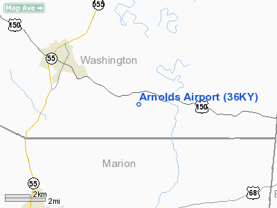
Location: |
Washington County, KY |
|
Magnetic Variation: |
02W (1985) |
Owner & Manager
|
Ownership: |
Privately owned |
|
Owner: |
Ray & Judy Johnson |
|
Address: |
858 Simmstown Road
Lebanon, KY 40033 |
|
Phone number: |
859-336-7121 |
|
Manager: |
Alan Laymon |
|
Address: |
1281 Simmstown Road
Lebanon, KY 40033 |
|
Phone number: |
859-336-8494 |
Airport Operations and Facilities
|
Airport Use: |
Private |
|
Wind indicator: |
Yes |
|
Segmented Circle: |
Yes |
|
Control Tower: |
No |
|
Landing fee charge: |
No |
|
Sectional chart: |
St Louis |
|
Region: |
ASO - Southern |
|
Boundary ARTCC: |
ZID - Indianapolis |
|
Tie-in FSS: |
LOU - Louisville |
|
FSS on Airport: |
No |
|
FSS Toll Free: |
1-800-WX-BRIEF |
Airport Services
|
Airframe
Repair: |
NONE |
|
Power
Plant Repair: |
NONE |
|
Bottled
Oxygen: |
NONE |
|
Bulk
Oxygen: |
NONE |
|
Runway Information
Runway 06/24
|
Dimension: |
2100 x 100 ft / 640.1 x 30.5 m |
|
Surface: |
TURF, Fair Condition
& 14/32 TURF SOFT WHEN WET. |
|
|
Runway 06
|
Runway 24
|
|
Traffic
Pattern: |
Left |
Left |
|
Obstruction: |
50 ft tree, 50.0 ft from runway, 1:1 slope to clear |
10 ft tree, 200.0 ft from runway, 50 ft right of
centerline, 20:1 slope to clear |
|
Runway 14/32
|
Dimension: |
2250 x 90 ft / 685.8 x 27.4 m |
|
Surface: |
TURF, Fair Condition
& 14/32 TURF SOFT WHEN WET. |
|
|
Runway 14
|
Runway 32
|
|
Traffic
Pattern: |
Left |
Left |
|
Obstruction: |
30 ft trees, 600.0 ft from runway, 100 ft left of
centerline, 20:1 slope to clear |
12 ft fence, 200.0 ft from runway, 16:1 slope to clear |
|
Radio Navigation Aids
|
ID |
Type |
Name |
Ch |
Freq |
Var |
Dist |
|
IKY |
NDB |
Springfield |
|
429.00 |
03W |
4.1 nm |
|
TYC |
NDB |
Taylor County |
|
272.00 |
02W |
15.8 nm |
|
DVK |
NDB |
Goodall |
|
311.00 |
03W |
19.2 nm |
|
BRY |
NDB |
Bardstown/dcmsnd |
|
248.00 |
02W |
19.4 nm |
|
LE |
NDB |
Blayd |
|
242.00 |
04W |
30.8 nm |
|
FEU |
NDB |
Arnold |
|
521.00 |
03W |
37.2 nm |
|
GOI |
NDB |
Godman |
|
396.00 |
02W |
43.1 nm |
|
CDX |
NDB |
Cumberland River |
|
388.00 |
05E |
45.6 nm |
|
FFT |
VOR |
Frankfort |
|
109.40 |
03W |
33.7 nm |
|
EWO |
VOR/DME |
New Hope |
045X |
110.80 |
01E |
24.9 nm |
|
FTK |
VOR/DME |
Fort Knox |
033X |
109.60 |
01W |
41.7 nm |
|
BQM |
VOR/DME |
Bowman |
059X |
112.20 |
01W |
42.2 nm |
|
IIU |
VORTAC |
Louisville |
095X |
114.80 |
01E |
33.6 nm |
|
HYK |
VORTAC |
Lexington |
073X |
112.60 |
00E |
37.4 nm |
|
SDF |
VOT |
Louisville Standifd |
|
111.00 |
|
41.8 nm |
Remarks
Based Aircraft
|
Aircraft based
on field: |
1 |
|
Single Engine
Airplanes: |
1 |
Operational Statistics
Time Period: 1989-12-12 - 1990-12-11
|
Aircraft
Operations: |
22/Week |
|
General
Aviation Local: |
45.5% |
|
General
Aviation Itinerant: |
45.5% |
|
Military: |
9.1% |
Arnolds Airport
Address:
Washington County, KY
Tel:
859-336-7121, 859-336-8494
Images
and information placed above are from
http://www.airport-data.com/airport/36KY/
We
thank them for the data!
|
General Info |
| Country |
United
States |
| State |
KENTUCKY
|
| FAA ID |
36KY
|
| Latitude |
37-39-20.239N |
|
Longitude |
085-09-13.854W |
|
Elevation |
843 feet
|
| Near
City |
SPRINGFIELD |
We don't guarantee the information is fresh and accurate. The data may
be wrong or outdated.
For more up-to-date information please refer to other sources.
|
|


