 |
|
Addington Field
Elizabethtown Regional Airport |
 |
| IATA: EKX â ICAO: KEKX â FAA LID: EKX |
| Summary |
| Airport type |
Public |
| Owner |
Elizabethtown Airport Board |
| Serves |
Elizabethtown, Kentucky |
| Elevation AMSL |
775 ft / 236 m |
| Coordinates |
37°41â²10â³N 085°55â²30â³W / 37.68611°N 85.925°W / 37.68611; -85.925 |
| Website |
www.EKXairport.com |
| Runways |
| Direction |
Length |
Surface |
| ft |
m |
| 5/23 |
6,001 |
1,829 |
Asphalt |
| Statistics (2008) |
| Aircraft operations |
12,400 |
| Based aircraft |
60 |
| Source: FAA and airport website |
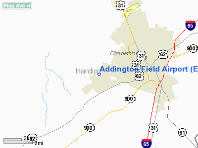
Elizabethtown Regional Airport (IATA: EKX, ICAO: KEKX, FAA LID: EKX), also known as Addington Field, is a public use airport located four nautical miles (7 km) west of the central business district of Elizabethtown, a city in Hardin County, Kentucky, United States. The airport is owned by the Elizabethtown Airport Board. It is used for general aviation, but current exploration of commercial aviation is underway. The last commercial flight took place in the late 1980s.
Addington Field opened in 1982. In February 2007, the airport board changed the name to Addington Field / Elizabethtown Regional Airport. The new name appears on airport's website and in its logo, but the Federal Aviation Administration still shows the name as Addington Field (as per the airport's master record effective July 2009). Facilities and aircraft
Addington Field covers an area of 210 acres (85 ha) at an elevation of 775 feet (236 m) above mean sea level. It has one asphalt tarmec runway designated 5/23 which measures 6,001 by 100 feet (1,829 x 30 m).
For the 12-month period ending June 5, 2008, the airport had 12,400 aircraft operations, an average of 33 per day: 90% general aviation, 8% air taxi and 2% military. At that time there were 60 aircraft based at this airport: 82% single-engine, 13% multi-engine and 5% helicopter.
Parachute operations
Parachuting/Skydiving operations are regularly conducted at Addington Field, inbound aircraft are advised to be cautious and listen to all traffic advisories.
Jumpers exit aircraft over Addington Field from 3500-14000 feet and are normally seen under canopy returning to earth via a left landing pattern (all left turns @ 1000, 600 and 300 feet); the pattern entrance is wind dependent.
Inbound or outbound pilots should call 270-723-3587 or stop by hanger 2 and ask about the days operations if they are concerned or just interested in jumping and/or parachute rigging services for their emergency pilot rigs (or any other parachute rig).
Pictures
The above content comes from Wikipedia and is published under free licenses – click here to read more.
|
Location &
QuickFacts
|
FAA
Information Effective: |
2008-09-25 |
|
Airport
Identifier: |
EKX |
|
Airport
Status: |
Operational |
|
Longitude/Latitude: |
085-55-30.1000W/37-41-09.6000N
-85.925028/37.686000 (Estimated) |
|
Elevation: |
775 ft / 236.22 m (Surveyed) |
|
Land: |
210 acres |
|
From
nearest city: |
4 nautical miles W of Elizabethtown, KY |
|
Location: |
Hardin County, KY |
|
Magnetic Variation: |
03W (2005) |
Owner & Manager
|
Ownership: |
Publicly owned |
|
Owner: |
Elizabethtown Airport Board |
|
Address: |
1828 Kitty Hawk Dr
Elizabethtown, KY 42701 |
|
Phone
number: |
520-624-8672
AIR BOARD CHAIRMAN JOSEPH YATES. |
|
Manager: |
Roger Lawson |
|
Address: |
Elizabethtown Airport Board, 1828 Kitty Hawk Dr
Elizabethtown, KY 42701 |
|
Phone number: |
270-737-8388
ALSO 270-769-9100. |
Airport Operations and Facilities
|
Airport
Use: |
Open to public |
|
Wind
indicator: |
Yes |
|
Segmented Circle: |
Yes |
|
Control
Tower: |
No |
|
Lighting
Schedule: |
DUSK-DAWN
MIRL RY 05/23 PRESET LOW INTST & REIL RYS 05 & 23 OPER DUSK-DAWN; TO
INCR INTST MIRL RY 05/23 & ACTVT REIL RYS 05 & 23 - CTAF.
PAPI RYS 05 & 23 OPER 24 HRS. |
|
Beacon
Color: |
Clear-Green (lighted land airport) |
|
Landing
fee charge: |
No |
|
Sectional chart: |
St Louis |
|
Region: |
ASO - Southern |
|
Boundary
ARTCC: |
ZID - Indianapolis |
|
Tie-in
FSS: |
LOU - Louisville |
|
FSS on
Airport: |
No |
|
FSS Toll
Free: |
1-800-WX-BRIEF |
|
NOTAMs
Facility: |
LOU (NOTAM-d service avaliable) |
|
Federal Agreements: |
NGY |
Airport Communications
|
CTAF: |
122.800 |
|
Unicom: |
122.800 |
Airport Services
|
Fuel
available: |
100LLA |
|
Airframe
Repair: |
MAJOR |
|
Power
Plant Repair: |
MAJOR |
|
Bottled
Oxygen: |
NONE |
|
Bulk
Oxygen: |
NONE |
|
Runway Information
Runway 05/23
|
Dimension: |
6001 x 100 ft / 1829.1 x 30.5 m |
|
Surface: |
ASPH, Good Condition |
|
Weight Limit: |
Single wheel: 35000 lbs. |
|
Edge Lights: |
Medium |
|
|
Runway 05
|
Runway 23
|
|
Longitude: |
085-55-57.2700W |
085-55-03.0000W |
|
Latitude: |
37-40-49.2600N |
37-41-29.9900N |
|
Elevation: |
750.00 ft |
775.00 ft |
|
Alignment: |
47 |
127 |
|
ILS Type: |
LOC/DME |
|
|
Traffic
Pattern: |
Left |
Left |
|
Markings: |
Non-precision instrument, Good Condition |
Non-precision instrument, Good Condition |
|
Crossing
Height: |
36.00 ft |
30.00 ft |
|
VASI: |
4-light PAPI on left side |
4-light PAPI on left side |
|
Visual
Glide Angle: |
3.00° |
3.00° |
|
Runway End
Identifier: |
Yes |
Yes |
|
Obstruction: |
82 ft tree, 2350.0 ft from runway, 300 ft right of
centerline, 26:1 slope to clear |
, 50:1 slope to clear |
|
Radio Navigation Aids
|
ID |
Type |
Name |
Ch |
Freq |
Var |
Dist |
|
GOI |
NDB |
Godman |
|
396.00 |
02W |
16.6 nm |
|
BRY |
NDB |
Bardstown/dcmsnd |
|
248.00 |
02W |
23.1 nm |
|
IKY |
NDB |
Springfield |
|
429.00 |
03W |
32.9 nm |
|
TYC |
NDB |
Taylor County |
|
272.00 |
02W |
36.7 nm |
|
BVQ |
NDB |
Beaver Creek |
|
260.00 |
02W |
40.4 nm |
|
TEL |
NDB |
Tell City |
|
206.00 |
02W |
41.3 nm |
|
MYS |
VOR |
Mystic |
|
108.20 |
01W |
19.7 nm |
|
EWO |
VOR/DME |
New Hope |
045X |
110.80 |
01E |
12.3 nm |
|
FTK |
VOR/DME |
Fort Knox |
033X |
109.60 |
01W |
13.5 nm |
|
BQM |
VOR/DME |
Bowman |
059X |
112.20 |
01W |
35.0 nm |
|
IIU |
VORTAC |
Louisville |
095X |
114.80 |
01E |
30.0 nm |
|
SDF |
VOT |
Louisville Standifd |
|
111.00 |
|
30.9 nm |
Remarks
-
DEER AND BIRDS ON
AND INVOF ARPT.
Based Aircraft
|
Aircraft based
on field: |
60 |
|
Single Engine
Airplanes: |
49 |
|
Multi Engine
Airplanes: |
8 |
|
Helicopters: |
3 |
Operational Statistics
Time Period: 2004-09-16 - 2005-09-15
|
Aircraft
Operations: |
239/Week |
|
Air Taxi: |
8.1% |
|
General
Aviation Local: |
37.1% |
|
General
Aviation Itinerant: |
52.4% |
|
Military: |
2.4% |
Addington Field Airport
Address:
Hardin County, KY
Tel:
520-624-8672, 270-737-8388, 270-769-9100
Images
and information placed above are from
http://www.airport-data.com/airport/EKX/
We
thank them for the data!
|
General Info |
| Country |
United
States |
| State |
KENTUCKY
|
| FAA ID |
EKX
|
| Latitude |
37-41-13.000N |
|
Longitude |
085-55-25.600W |
|
Elevation |
775 feet
|
| Near
City |
ELIZABETHTOWN |
We don't guarantee the information is fresh and accurate. The data may
be wrong or outdated.
For more up-to-date information please refer to other sources.
|
|


