 |
|
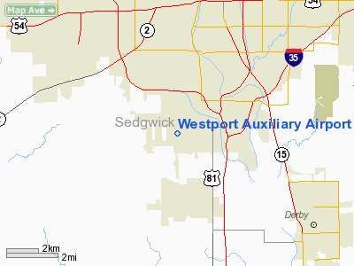
Westport Auxiliary Airport |
|
Location &
QuickFacts
|
FAA
Information Effective: |
2008-09-25 |
|
Airport
Identifier: |
72K |
|
Airport
Status: |
Operational |
|
Longitude/Latitude: |
097-21-32.1620W/37-36-15.0570N
-97.358934/37.604183 (Estimated) |
|
Elevation: |
1270 ft / 387.10 m (Estimated) |
|
Land: |
60 acres |
|
From
nearest city: |
5 nautical miles SW of Wichita, KS |
|
Location: |
Sedgwick County, KS |
|
Magnetic Variation: |
07E (1985) |
Owner & Manager
|
Ownership: |
Privately owned |
|
Owner: |
Earl Long |
|
Address: |
1801 W 47 St S
Wichita, KS 67217 |
|
Phone
number: |
316-943-5510 |
|
Manager: |
Earl Long |
|
Address: |
1801 W 47 St S
Wichita, KS 67217 |
|
Phone number: |
316-943-5510 |
Airport Operations and Facilities
|
Airport
Use: |
Open to public |
|
Wind
indicator: |
Yes |
|
Segmented Circle: |
No |
|
Control
Tower: |
No |
|
Landing
fee charge: |
No |
|
Sectional chart: |
Wichita |
|
Region: |
ACE - Central |
|
Boundary
ARTCC: |
ZKC - Kansas City |
|
Tie-in
FSS: |
ICT - Wichita |
|
FSS on
Airport: |
No |
|
FSS Toll
Free: |
1-800-WX-BRIEF |
|
NOTAMs
Facility: |
ICT (NOTAM-d service avaliable) |
Airport Communications
Airport Services
|
Runway Information
Runway 17/35
|
Dimension: |
2550 x 50 ft / 777.2 x 15.2 m |
|
Surface: |
TURF, Fair Condition
ROUGH & BUMPY. |
|
|
Runway 17
|
Runway 35
|
|
Traffic
Pattern: |
Left |
Left |
|
Obstruction: |
60 ft pline, 40.0 ft from runway |
3 ft fence, 0.0 ft from runway |
|
Radio Navigation Aids
|
ID |
Type |
Name |
Ch |
Freq |
Var |
Dist |
|
IC |
NDB |
Piche |
|
332.00 |
07E |
4.9 nm |
|
EGT |
NDB |
Wellington |
|
414.00 |
07E |
16.9 nm |
|
EQA |
NDB |
El Dorado |
|
383.00 |
05E |
27.9 nm |
|
EWK |
NDB |
Newton |
|
281.00 |
06E |
27.9 nm |
|
MPR |
NDB |
Mc Pherson |
|
227.00 |
06E |
47.4 nm |
|
PN |
NDB |
Ponca |
|
515.00 |
05E |
48.4 nm |
|
IAB |
TACAN |
Mc Connell |
112X |
|
07E |
4.4 nm |
|
HUT |
VOR/DME |
Hutchinson |
115X |
116.80 |
09E |
36.1 nm |
|
ICT |
VORTAC |
Wichita |
085X |
113.80 |
07E |
13.7 nm |
|
ANY |
VORTAC |
Anthony |
076X |
112.90 |
07E |
47.1 nm |
|
ICT |
VOT |
Wichita |
|
114.00 |
|
4.1 nm |
Remarks
-
ROAD CROSSES N
END RY 17/35.
-
IF CONDS
FAVORABLE BALLON TFC IN AREA.
-
EXISTED PRIOR TO 1959.
Based Aircraft
|
Aircraft based
on field: |
2 |
|
Single Engine
Airplanes: |
2 |
Operational Statistics
Time Period: 2007-05-01 - 2008-04-29
|
Aircraft
Operations: |
10/Month |
|
General
Aviation Local: |
83.3% |
|
General
Aviation Itinerant: |
16.7% |
Westport Auxiliary Airport
Address:
Sedgwick County, KS
Tel:
316-943-5510
Images
and information placed above are from
http://www.airport-data.com/airport/72K/
We
thank them for the data!
|
General Info |
| Country |
United
States |
| State |
KANSAS
|
| FAA ID |
72K
|
| Latitude |
37-36-15.057N |
|
Longitude |
097-21-32.162W |
|
Elevation |
1270
feet |
| Near
City |
WICHITA
|
We don't guarantee the information is fresh and accurate. The data may
be wrong or outdated.
For more up-to-date information please refer to other sources.
|
|


