 |
|
Wellington Municipal Airport |
| Wellington Municipal Airport |
| IATA: none â ICAO: KEGT â FAA LID: EGT |
| Summary |
| Airport type |
Public |
| Owner |
City of Wellington |
| Serves |
Wellington, Kansas |
| Elevation AMSL |
1,277 ft / 389 m |
| Coordinates |
37°19â²25â³N 097°23â²18â³W / 37.32361°N 97.38833°W / 37.32361; -97.38833 |
| Runways |
| Direction |
Length |
Surface |
| ft |
m |
| 17/35 |
4,201 |
1,280 |
Concrete |
| Statistics (2008) |
| Aircraft operations |
18,050 |
| Based aircraft |
34 |
| Source: Federal Aviation Administration |
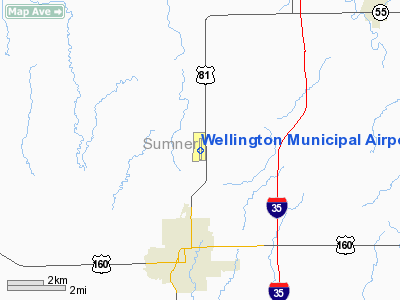
Wellington Municipal Airport (ICAO: KEGT, FAA LID: EGT) is a city-owned public-use airport located three nautical miles (6 km) north of the central business district of Wellington, a city in Sumner County, Kansas, United States.
Although most U.S. airports use the same three-letter location identifier for the FAA and IATA, this airport is assigned EGT by the FAA but has no designation from the IATA.
Facilities and aircraft
Wellington Municipal Airport covers an area of 190 acres (77 ha) at an elevation of 1,277 feet (389 m) above mean sea level. It has one runway designated 17/35 with a concrete surface measuring 4,201 by 100 feet (1,280 x 30 m).
For the 12-month period ending November 19, 2008, the airport had 18,050 aircraft operations, an average of 49 per day: 99.7% general aviation and 0.3% military. At that time there were 34 aircraft based at this airport: 94% single-engine and 6% multi-engine.
The above content comes from Wikipedia and is published under free licenses – click here to read more.
|
Location &
QuickFacts
|
FAA
Information Effective: |
2008-09-25 |
|
Airport
Identifier: |
EGT |
|
Airport
Status: |
Operational |
|
Longitude/Latitude: |
097-23-18.0000W/37-19-25.0000N
-97.388333/37.323611 (Estimated) |
|
Elevation: |
1277 ft / 389.23 m (Surveyed) |
|
Land: |
190 acres |
|
From
nearest city: |
3 nautical miles N of Wellington, KS |
|
Location: |
Sumner County, KS |
|
Magnetic Variation: |
07E (1990) |
Owner & Manager
|
Ownership: |
Publicly owned |
|
Owner: |
City Of Wellington |
|
Address: |
441 North West Road
Wellington, KS 67152 |
|
Phone number: |
620-326-5717 |
|
Manager: |
Patrick Hamlin |
|
Address: |
Box 644
Wellington, KS 67152 |
|
Phone number: |
620-326-5717
TERMINAL BLDG. FAX 620-326-5717 |
Airport
Operations and Facilities
|
Airport
Use: |
Open to public |
|
Wind
indicator: |
Yes |
|
Segmented Circle: |
No |
|
Control
Tower: |
No |
|
Lighting
Schedule: |
DUSK-DAWN
ACTVT HIRL RY 17/35; REIL RYS 17 & 35 - CTAF. PAPI RYS 17 & 35 ARE ON
24 HRS. |
|
Beacon
Color: |
Clear-Green (lighted land airport) |
|
Landing
fee charge: |
No |
|
Sectional chart: |
Wichita |
|
Region: |
ACE - Central |
|
Boundary
ARTCC: |
ZKC - Kansas City |
|
Tie-in
FSS: |
ICT - Wichita |
|
FSS on
Airport: |
No |
|
FSS Toll
Free: |
1-800-WX-BRIEF |
|
NOTAMs
Facility: |
ICT (NOTAM-d service avaliable) |
|
Federal Agreements: |
NGY |
Airport Communications
|
CTAF: |
122.800 |
|
Unicom: |
122.800 |
Airport Services
|
Fuel
available: |
100LLA
FOR JET-A FUEL AFT HRS CALL 620-440-4254 OR 620-326-5717. |
|
Airframe
Repair: |
MAJOR |
|
Power
Plant Repair: |
MAJOR |
|
Bottled
Oxygen: |
NONE |
|
Bulk
Oxygen: |
NONE |
|
Runway Information
Runway 17/35
|
Dimension: |
4201 x 100 ft / 1280.5 x 30.5 m |
|
Surface: |
CONC, Good Condition |
|
Weight Limit: |
Single wheel: 49000 lbs.
Dual wheel: 60000 lbs. |
|
Edge Lights: |
High |
|
|
Runway 17
|
Runway 35
|
|
Longitude: |
097-23-18.2792W |
097-23-17.7593W |
|
Latitude: |
37-19-45.8038N |
37-19-04.2786N |
|
Elevation: |
1276.00 ft |
1271.00 ft |
|
Alignment: |
127 |
127 |
|
Traffic
Pattern: |
Left |
Left |
|
Markings: |
Non-precision instrument, Good Condition |
Non-precision instrument, Good Condition |
|
Crossing
Height: |
40.00 ft |
40.00 ft |
|
VASI: |
2-light PAPI on left side |
2-light PAPI on left side |
|
Visual
Glide Angle: |
3.00° |
3.00° |
|
Runway End
Identifier: |
Yes |
Yes |
|
Radio Navigation Aids
|
ID |
Type |
Name |
Ch |
Freq |
Var |
Dist |
|
IC |
NDB |
Piche |
|
332.00 |
07E |
15.6 nm |
|
PN |
NDB |
Ponca |
|
515.00 |
05E |
33.0 nm |
|
EQA |
NDB |
El Dorado |
|
383.00 |
05E |
38.6 nm |
|
EWK |
NDB |
Newton |
|
281.00 |
06E |
44.8 nm |
|
IAB |
TACAN |
Mc Connell |
112X |
|
07E |
18.8 nm |
|
HUT |
VOR/DME |
Hutchinson |
115X |
116.80 |
09E |
48.1 nm |
|
ICT |
VORTAC |
Wichita |
085X |
113.80 |
07E |
27.0 nm |
|
PER |
VORTAC |
Pioneer |
079X |
113.20 |
06E |
36.4 nm |
|
ANY |
VORTAC |
Anthony |
076X |
112.90 |
07E |
38.7 nm |
|
ICT |
VOT |
Wichita |
|
114.00 |
|
18.9 nm |
Remarks
-
FOR SPECIAL REQUESTS CALL
620-326-5717.
Based Aircraft
|
Aircraft based
on field: |
35 |
|
Single Engine
Airplanes: |
32 |
|
Multi Engine
Airplanes: |
2 |
|
Jet Engine
Airplanes: |
1 |
Operational Statistics
Time Period: 2006-06-09 - 2007-06-08
|
Aircraft
Operations: |
50/Day |
|
General
Aviation Local: |
44.4% |
|
General
Aviation Itinerant: |
55.6% |
Wellington Municipal Airport
Address:
Sumner County, KS
Tel:
620-326-5717
Images
and information placed above are from
http://www.airport-data.com/airport/EGT/
We
thank them for the data!
|
General Info |
| Country |
United
States |
| State |
KANSAS
|
| FAA ID |
EGT
|
| Latitude |
37-19-27.877N |
|
Longitude |
097-23-14.364W |
|
Elevation |
1273
feet |
| Near
City |
WELLINGTON |
We don't guarantee the information is fresh and accurate. The data may
be wrong or outdated.
For more up-to-date information please refer to other sources.
|
|


