 |
|
| Tri-City Airport |
| IATA: PPF â ICAO: KPPF â FAA LID: PPF |
| Summary |
| Airport type |
Public |
| Owner |
City of Parsons |
| Serves |
Parsons, Kansas |
| Elevation AMSL |
900 ft / 274 m |
| Coordinates |
37°19â²51â³N 095°30â²22â³W / 37.33083°N 95.50611°W / 37.33083; -95.50611 |
| Runways |
| Direction |
Length |
Surface |
| ft |
m |
| 17/35 |
5,000 |
1,524 |
Concrete |
| Statistics (2008) |
| Aircraft operations |
6,000 |
| Based aircraft |
15 |
| Source: Federal Aviation Administration |
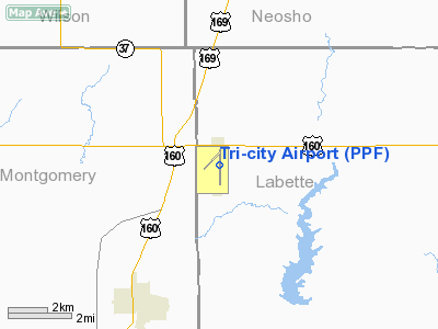
Tri-City Airport (IATA: PPF, ICAO: KPPF, FAA LID: PPF) is a city-owned public-use airport located 11 nautical miles (20 km) west of the central business district of Parsons, a city in Labette County, Kansas, United States.
Between 1979 and 1986, PPF was served by Air Midwest operating under Eastern Airlines. The aircraft used was a 19-seat Swearingen Metroliner.
Facilities and aircraft
Tri-City Airport covers an area of 802 acres (325 ha) at an elevation of 900 feet (274 m) above mean sea level. It has one runway designated 17/35 with a concrete surface measuring 5,000 by 75 feet (1,524 x 23 m).
For the 12-month period ending July 3, 2008, the airport had 6,000 aircraft operations, an average of 16 per day: 92% general aviation, 5% air taxi and 3% military. At that time there were 15 aircraft based at this airport: 87% single-engine and 13% multi-engine.
The above content comes from Wikipedia and is published under free licenses – click here to read more.
|
Location &
QuickFacts
|
FAA
Information Effective: |
2008-09-25 |
|
Airport
Identifier: |
PPF |
|
Airport
Status: |
Operational |
|
Longitude/Latitude: |
095-30-22.2000W/37-19-50.9000N
-95.506167/37.330806 (Estimated) |
|
Elevation: |
900 ft / 274.32 m (Surveyed) |
|
Land: |
802 acres |
|
From
nearest city: |
11 nautical miles W of Parsons, KS |
|
Location: |
Labette County, KS |
|
Magnetic Variation: |
06E (1985) |
Owner & Manager
|
Ownership: |
Publicly owned |
|
Owner: |
City Of Parsons |
|
Address: |
Municipal Building
Parsons, KS 67357 |
|
Phone number: |
620-421-7000 |
|
Manager: |
Randy Trout |
|
Address: |
163 24000 Rd
Cherryvale, KS 67335 |
|
Phone number: |
620-336-3440 |
Airport
Operations and Facilities
|
Airport
Use: |
Open to public |
|
Wind
indicator: |
Yes |
|
Segmented Circle: |
No |
|
Control
Tower: |
No |
|
Lighting
Schedule: |
DUSK-DAWN
MIRL RY 17/35 OPER DUSK-2300; AFT 2300 ACTVT - CTAF.
ACTVT
VASI RYS 17 & 35 - CTAF. |
|
Beacon
Color: |
Clear-Green (lighted land airport) |
|
Landing
fee charge: |
No |
|
Sectional chart: |
Kansas City |
|
Region: |
ACE - Central |
|
Boundary
ARTCC: |
ZKC - Kansas City |
|
Tie-in
FSS: |
ICT - Wichita |
|
FSS on
Airport: |
No |
|
FSS Toll
Free: |
1-800-WX-BRIEF |
|
NOTAMs
Facility: |
PPF (NOTAM-d service avaliable) |
|
Federal Agreements: |
NGRY |
Airport Communications
|
CTAF: |
123.000 |
|
Unicom: |
123.000 |
Airport Services
|
Fuel
available: |
100LLA |
|
Airframe
Repair: |
MINOR |
|
Power
Plant Repair: |
MINOR |
|
Bottled
Oxygen: |
NONE |
|
Bulk
Oxygen: |
NONE |
|
Runway Information
Runway 17/35
|
Dimension: |
5000 x 75 ft / 1524.0 x 22.9 m |
|
Surface: |
CONC, |
|
Weight Limit: |
Single wheel: 25000 lbs.
Dual wheel: 45000 lbs. |
|
Edge Lights: |
Medium |
|
|
Runway 17
|
Runway 35
|
|
Longitude: |
095-30-22.4276W |
095-30-22.0274W |
|
Latitude: |
37-20-15.6432N |
37-19-26.2130N |
|
Elevation: |
900.00 ft |
865.00 ft |
|
Alignment: |
127 |
127 |
|
Traffic
Pattern: |
Left |
Left |
|
Markings: |
Non-precision instrument, Good Condition |
Non-precision instrument, Good Condition |
|
Crossing
Height: |
35.00 ft |
39.00 ft |
|
VASI: |
4-box on left side |
4-box on left side |
|
Visual
Glide Angle: |
3.00° |
3.00° |
|
Runway End
Identifier: |
Yes |
Yes |
|
Obstruction: |
25 ft road, 729.0 ft from runway, 21:1 slope to clear |
18 ft trees, 200.0 ft from runway, 240 ft left of
centerline
15 FT TREES 60 FT FM RY END 235 FT L. |
|
Radio Navigation Aids
|
ID |
Type |
Name |
Ch |
Freq |
Var |
Dist |
|
PPF |
NDB |
Parsons |
|
258.00 |
06E |
0.5 nm |
|
CFV |
NDB |
Coffeyville |
|
212.00 |
05E |
14.6 nm |
|
MSB |
NDB |
Monarch |
|
410.00 |
04E |
28.0 nm |
|
PTS |
NDB |
Pittsburg |
|
365.00 |
05E |
37.8 nm |
|
FSK |
NDB |
Fort Scott |
|
379.00 |
05E |
45.1 nm |
|
CNU |
VOR/DME |
Chanute |
029X |
109.20 |
05E |
18.2 nm |
|
BVO |
VOR/DME |
Bartlesville |
126X |
117.90 |
08E |
38.7 nm |
|
OSW |
VORTAC |
Oswego |
123X |
117.60 |
08E |
17.8 nm |
Remarks
-
SOUTH TWY CLSD PERMLY.
-
DEER ON & INVOF RYS.
-
PRVDD APCHS TO
RWY 17-35 ARE MAINTD FOR A MIN 34:1 GLIDE SLOPE & THE TRSNL SFC MAINTD FOR A
7:1 SLOPE.
Based Aircraft
|
Aircraft based
on field: |
15 |
|
Single Engine
Airplanes: |
13 |
|
Multi Engine
Airplanes: |
2 |
Operational Statistics
Time Period: 2007-07-05 - 2008-07-03
|
Aircraft
Operations: |
116/Week |
|
Air Taxi: |
5.0% |
|
General
Aviation Local: |
41.7% |
|
General
Aviation Itinerant: |
50.0% |
|
Military: |
3.3% |
Tri-city Airport
Address:
Labette County, KS
Tel:
620-421-7000, 620-336-3440
Images
and information placed above are from
http://www.airport-data.com/airport/PPF/
We
thank them for the data!
|
General Info |
| Country |
United
States |
| State |
KANSAS
|
| FAA ID |
PPF
|
| Latitude |
37-19-52.528N |
|
Longitude |
095-30-32.424W |
|
Elevation |
899 feet
|
| Near
City |
PARSONS
|
We don't guarantee the information is fresh and accurate. The data may
be wrong or outdated.
For more up-to-date information please refer to other sources.
|
|


