 |
|
|
|
|
|
|
Location &
QuickFacts
|
FAA
Information Effective: |
2008-09-25 |
|
Airport
Identifier: |
5KS1 |
|
Airport
Status: |
Operational |
|
Longitude/Latitude: |
095-12-58.8000W/39-11-37.8000N
-95.216333/39.193833 (Estimated) |
|
Elevation: |
1150 ft / 350.52 m (Estimated) |
|
Land: |
3 acres |
|
From
nearest city: |
1 nautical miles SW of Mc Louth, KS |
|
Location: |
Jefferson County, KS |
|
Magnetic Variation: |
05E (1985) |
Owner & Manager
|
Ownership: |
Privately owned |
|
Owner: |
Heart Of America/ A.j. Leftwich |
|
Address: |
18865 K-16 Highway, Po Box 344
Mc Louth, KS 66054 |
|
Phone
number: |
913-796-6562 |
|
Manager: |
Heart Of America Association |
|
Address: |
911 S. Home St.
Mc Louth, KS 66054 |
|
Phone number: |
913-796-6103 |
Airport Operations and Facilities
|
Airport
Use: |
Private |
|
Wind
indicator: |
Yes |
|
Segmented Circle: |
No |
|
Control
Tower: |
No |
|
Landing
fee charge: |
No |
|
Sectional chart: |
Kansas City |
|
Region: |
ACE - Central |
|
Boundary
ARTCC: |
ZKC - Kansas City |
|
Tie-in
FSS: |
ICT - Wichita |
|
FSS on
Airport: |
No |
|
FSS Toll
Free: |
1-800-WX-BRIEF
FOR TOLL FREE IFR FILE/CLOSE FP ONLY: 1-800-322-2377. |
Airport Services
|
Airframe
Repair: |
NONE |
|
Power
Plant Repair: |
NONE |
|
Runway Information
Runway 18/36
|
Dimension: |
1650 x 60 ft / 502.9 x 18.3 m |
|
Surface: |
TURF, Good Condition |
|
|
Runway 18
|
Runway 36
|
|
Traffic
Pattern: |
Left |
Left |
|
Displaced
threshold: |
300.00 ft |
100.00 ft |
|
Obstruction: |
2 ft road, 20.0 ft from runway |
5 ft fence, 0.0 ft from runway |
|
Radio Navigation Aids
|
ID |
Type |
Name |
Ch |
Freq |
Var |
Dist |
|
DO |
NDB |
Dotte |
|
359.00 |
05E |
21.8 nm |
|
TO |
NDB |
Biloy |
|
521.00 |
05E |
22.4 nm |
|
GQ |
NDB |
Norge |
|
517.00 |
05E |
27.3 nm |
|
GKB |
NDB |
Norge |
|
517.00 |
05E |
27.3 nm |
|
LXT |
NDB |
Lesumit |
|
263.00 |
04E |
41.8 nm |
|
GPH |
NDB |
Mosby |
|
284.00 |
03E |
43.3 nm |
|
AZN |
NDB |
Amazon |
|
233.00 |
06E |
43.9 nm |
|
FOE |
TACAN |
Forbes |
053X |
|
05E |
25.5 nm |
|
RIS |
VOR/DME |
Riverside |
051X |
111.40 |
05E |
29.2 nm |
|
OJC |
VOR/DME |
Johnson County |
077X |
113.00 |
06E |
30.9 nm |
|
RBA |
VOR/DME |
Robinson |
019X |
108.20 |
04E |
40.6 nm |
|
TOP |
VORTAC |
Topeka |
125X |
117.80 |
05E |
15.9 nm |
|
MCI |
VORTAC |
Kansas City |
079Y |
113.25 |
05E |
23.0 nm |
|
STJ |
VORTAC |
St Joseph |
102X |
115.50 |
08E |
48.0 nm |
|
FOE |
VOT |
Forbes |
|
111.00 |
|
25.6 nm |
|
MKC |
VOT |
Kansas City Downtown |
|
108.60 |
|
29.1 nm |
Remarks
-
DURG FIRST WKEND
AUG HEAVY ACTIVITY: CONVENTIONAL, EXPERIMENTAL, & ROTOR ACFT.
-
PRVDD APCHS TO
RWYS MAINTD FOR A 20:1 GLIDE SLOPE AND THAT TRSNL SFC MAINTD FOR A 7:1 SLOPE.
Based Aircraft
|
Aircraft based
on field: |
1 |
|
Ultralights: |
1 |
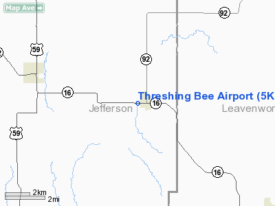
Threshing Bee Airport
Address:
Jefferson County, KS
Tel:
913-796-6562,
913-796-6103
Images
and information placed above are from
http://www.airport-data.com/airport/5KS1/
We
thank them for the data!
|
General Info |
| Country |
United
States |
| State |
KANSAS
|
| FAA ID |
5KS1
|
| Latitude |
39-11-37.800N |
|
Longitude |
095-12-58.800W |
|
Elevation |
1150
feet |
| Near
City |
MC LOUTH
|
We don't guarantee the information is fresh and accurate. The data may
be wrong or outdated.
For more up-to-date information please refer to other sources.
|
|


