|
 |
|
||||
|
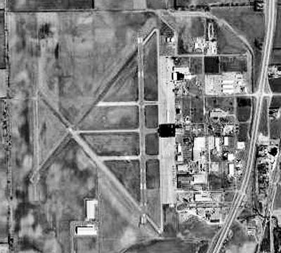
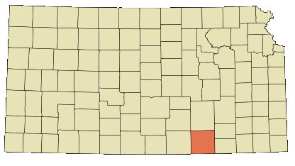
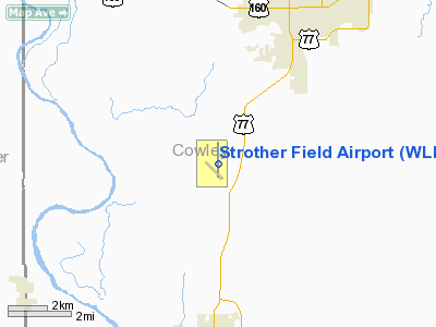
1976 USGS airphoto of Strother Field Strother Field (IATA: WLD, ICAO: KWLD, FAA LID: WLD) is a public airport located in Cowley County, Kansas, five miles (8 km) southwest of the central business district of Winfield and north of Arkansas City. This airport is jointly owned by both cities. Facilities and aircraftStrother Field covers an area of 1,530 acres (619 ha) which contains two runways:
For 12-month period ending November 4, 2005, the airport had 6,500 aircraft operations, an average of 17 per day, 100% of which were general aviation. There are 23 aircraft based at this airport: 78% single engine, 9% multi-engine, 4% jet aircraft and 9% ultralights. HistoryAn airport, jointly owned by Arkansas City and Winfield, was under construction in April 1942 when the United States Army Air Forces indicated a need for the airfield as a training airfield by the Army Air Forces Flying Training Command, Gulf Coast Training Center. Winfield Army Airfield was rushed to completion with the first class of cadets scheduled to arrive for basic training in the BT-13 on December 14, 1942. It was renamed Strother Army Air Field on 1 November 1942 in honor of Capt. Donald Root Strother, a Winfield native who was the first Army Air Force pilot from Cowley County to be killed in World War II. The immediate construction involved runways and airplane hangars, with three concrete runways, several taxiways and a large parking apron and a control tower. Four large hangars were also constructed. Buildings were ultimately utilitarian and quickly assembled. Most base buildings, not meant for long-term use, were constructed of temporary or semi-permanent materials. Although some hangars had steel frames and the occasional brick or tile brick building could be seen, most support buildings sat on concrete foundations but were of frame construction clad in little more than plywood and tarpaper. Strother Field was activated on 14 November 1942 as a basic flying training airfield. Units activated at the airfield were the 108th Guard Squadron; 448th Base Headquarters and Air Base Squadron; 332d Aviation Squadron; 1082d, 1083d, and 1084th Basic Training Flyling Squadrons; 32d Flying Training Wing (Basic). Strother received its aviation cadets from Fort Sumner, New Mexico and Majors Field, Texas. On 1 July 1944, control of Strother AAF was transferred to Second Air Force, and the mission of the airfield became advanced fighter pilot training in P-47 Thunderbolts. Ground personnel were assigned to the 269th Army Air Forces Base Unit (Fighter Pilot Training Station). At the peak of operation there were approximately 3,400 Air Force personnel and 400 civilian employees at the field. In addition to Strother Field there were four auxiliary fields; northwest of Winfield, southeast of Strother Field, west of Arkansas City, and northwest of Gueda Springs. The military use of Strother Field ended in October 1945 and it was turned over for civil use. Today, the site is currently Strother Field and Industrial Park. Remaining wartime structures include 2 hangars, 2 link training buildings, 1 tetrahedron wind cone, 2 ruins sites, 1 building of unknown original use and runways. The above content comes from Wikipedia and is published under free licenses – click here to read more.
Runway Information Runway 13/31
Runway 17/35
Radio Navigation Aids
Based Aircraft
Operational Statistics Time Period: 2004-11-05 - 2005-11-04
Strother Field Airport Address: Cowley County, KS Tel: 620-221-9280 Images
and information placed above are from We thank them for the data!
We don't guarantee the information is fresh and accurate. The data may
be wrong or outdated.
|
||||||||||||||||||||||||||||||||||||||||||||||||||||||||||||||||||||||||||||||||||||||||||||||||||||||||||||||||||||||||||||||||||||||||||||||||||||||||||||||||||||||||||||||||||||||||||||||||||||||||||||||||||||||||||||||||||||||||||||||||||||||||||||||||||||||||||||||||||||||||||||||||||||||||||||||||||||||||||||||||||||||||||||||||||||

 |
|
Copyright 2004-2026 © by Airports-Worldwide.com, Vyshenskoho st. 36, Lviv 79010, Ukraine Legal Disclaimer |