 |
|
| Sherman Army Airfield |
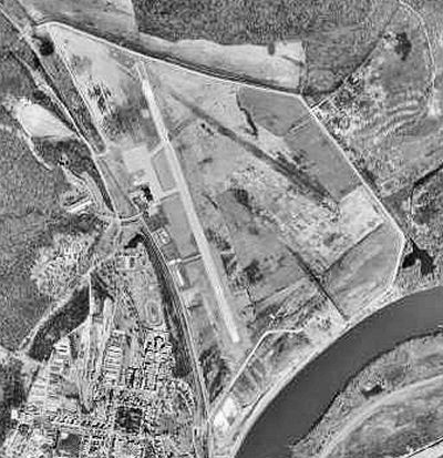 |
| USGS aerial photo, 27 March 1997 |
| IATA: FLV â ICAO: KFLV â FAA LID: FLV |
| Summary |
| Airport type |
Military / Public |
| Owner |
U.S. Army, Army Aviation Div. |
| Location |
Fort Leavenworth, Leavenworth, Kansas |
| Elevation AMSL |
772 ft / 235 m |
| Coordinates |
39°22â²06â³N 094°54â²53â³W / 39.36833°N 94.91472°W / 39.36833; -94.91472 |
| Runways |
| Direction |
Length |
Surface |
| ft |
m |
| 15/33 |
5,905 |
1,800 |
Asphalt/Concrete |
| Statistics (2008) |
| Aircraft operations |
20,400 |
| Based aircraft |
31 |
| Source: Federal Aviation Administration |
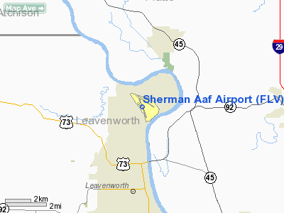
Sherman Army Airfield (IATA: FLV, ICAO: KFLV) is an airport located at Fort Leavenworth, Kansas, in Leavenworth County, Kansas. Although the airport is within the confines of a United States Army Base, it has agreement with the city of Leavenworth, Kansas to permit civilian use at all hours.
It derives its codes from Fort Leavenworth. It is named for American Civil War General William Tecumseh Sherman who spent extensive time at the Fort and helped establish the Command and General Staff College there.
The airport is at the foot of the Missouri River bluffs that make up the fort. The levee protecting it burst in both the Great Flood of 1951 and the Great Flood of 1993.
In 2002 the United States Disciplinary Barracks relocated from the middle of the fort to the northwest edge of the airport. In 2009 after it was announced that Guantanamo Bay detention camp detainees may be relocated to the Barracks, civilian leaders of the city and county of Leavenworth formally opposed the move because they fear it would mean an end to civilian use of the airport because of increased security. History
During World War II, the facility was used as a United States Army Air Forces Second Air Force training field.
Facilities and aircraft
Sherman AAF covers an area of 234 acres (95 ha) at an elevation of 772 feet (235 m) above mean sea level. It has one runway designated 15/33 with an asphalt/concrete surface measuring is 5,905 by 100 feet (1,800 x 30 m).
For the 12-month period ending September 30, 2008, the airport had 20,400 aircraft operations, an average of 55 per day: 94% general aviation and 6% military. At that time there were 31 aircraft based at this airport: 97% single-engine and 3% multi-engine.
The above content comes from Wikipedia and is published under free licenses – click here to read more.
|
Location &
QuickFacts
|
FAA
Information Effective: |
2008-09-25 |
|
Airport
Identifier: |
FLV |
|
Airport
Status: |
Operational |
|
Longitude/Latitude: |
094-54-52.8680W/39-22-05.9950N
-94.914686/39.368332 (Estimated) |
|
Elevation: |
772 ft / 235.31 m (Surveyed) |
|
Land: |
234 acres |
|
From
nearest city: |
3 nautical miles N of Fort Leavenworth, KS |
|
Location: |
Leavenworth County, KS |
|
Magnetic Variation: |
04E (2000) |
Owner & Manager
|
Ownership: |
Army owned
U.S. ARMY AIRFIELD/CIVILIAN RAMP LEASED TO CITY. |
|
Owner: |
U S Army, Army Aviation Div
CIVILIAN RAMP LEASED TO CITY. |
|
Address: |
Dir Of Plans, Trng & Mobilization, 296 Grant Ave.
Ft Leavenworth, KS 66027-1254 |
|
Phone
number: |
913-684-1781
FAX: 913-684-1793. |
|
Manager: |
Airfield Ops
CITY ARPT MGR BILLY SUMMERS. |
|
Address: |
1000 Chief Joseph Loop, Chief Joseph Loop
Ft. Leavenworth, KS 66027-1254 |
|
Phone
number: |
913-684-6041
ALT: 913-684-6039; FAX: 913-684-6034; FOR GENERAL AVIATION CONTACT
CITY OF LEAVENWORTH AIRPORT OFFICE, PHONE 913-651-0111, FAX:
913-651-6666. |
Airport
Operations and Facilities
|
Airport
Use: |
Open to public |
|
Wind
indicator: |
Yes |
|
Segmented Circle: |
No |
|
Control
Tower: |
No |
|
Lighting
Schedule: |
DUSK-DAWN
ACTVT HIRL RY 15/33 & PAPI RYS 15 & 33 & TWY LGTS - CTAF. |
|
Beacon
Color: |
Split-Clear-Green (lighted military airport) |
|
Landing
fee charge: |
No |
|
Sectional chart: |
Kansas City |
|
Region: |
ACE - Central |
|
Boundary
ARTCC: |
ZKC - Kansas City |
|
Tie-in
FSS: |
ICT - Wichita |
|
FSS on
Airport: |
No |
|
FSS Toll
Free: |
1-800-WX-BRIEF |
|
NOTAMs
Facility: |
ICT (NOTAM-d service avaliable) |
Airport Communications
Airport Services
|
Fuel
available: |
100LLA A1+
MIL FUEL AVBL 0730-1630L. 24 HR PPR. SVC OTR TIMES ONLY FOR CODE 4 &
ABV. GA 100LL & JET A AVBL 0900-1600L, OTR TIMES BY REQ. |
|
Airframe
Repair: |
NONE |
|
Power
Plant Repair: |
NONE |
|
Bottled
Oxygen: |
NONE |
|
Bulk
Oxygen: |
NONE |
|
Runway Information
Runway 15/33
|
Dimension: |
5905 x 100 ft / 1799.8 x 30.5 m |
|
Surface: |
ASPH-CONC, Fair Condition |
|
Pavement
Class: |
27 /F/C/W/T |
|
Weight Limit: |
Single wheel: 32000 lbs.
Dual wheel: 39000 lbs.
Dual tandem wheel: 97000 lbs.
Dual dual tandem wheel: 99000 lbs. |
|
Edge Lights: |
High |
|
|
Runway 15
|
Runway 33
|
|
Longitude: |
094-55-06.1880W |
094-54-39.7370W |
|
Latitude: |
39-22-33.3120N |
39-21-38.6840N |
|
Elevation: |
772.00 ft |
767.00 ft |
|
Alignment: |
127 |
127 |
|
Traffic
Pattern: |
Left |
Right |
|
Markings: |
Non-precision instrument, Good Condition |
Non-precision instrument, Good Condition |
|
Crossing
Height: |
40.00 ft |
41.00 ft |
|
Displaced
threshold: |
586.00 ft |
0.00 ft |
|
VASI: |
4-light PAPI on left side |
4-light PAPI on left side |
|
Visual
Glide Angle: |
3.00° |
3.00° |
|
Obstruction: |
100 ft trees, 879.0 ft from runway, 257 ft left of
centerline, 6:1 slope to clear
OBSTN CLNC SLOPE TO DSPLCD THLD 14:1.
+19 FT LGTD LEVEE 135 FT FROM RY END, OB (PVT ROAD ON TOP OF +9 FT
LEVEE). |
96 ft trees, 2835.0 ft from runway, 148 ft right of
centerline, 27:1 slope to clear |
|
Radio Navigation Aids
|
ID |
Type |
Name |
Ch |
Freq |
Var |
Dist |
|
DO |
NDB |
Dotte |
|
359.00 |
05E |
11.7 nm |
|
GQ |
NDB |
Norge |
|
517.00 |
05E |
22.1 nm |
|
GKB |
NDB |
Norge |
|
517.00 |
05E |
22.1 nm |
|
GPH |
NDB |
Mosby |
|
284.00 |
03E |
28.3 nm |
|
AZN |
NDB |
Amazon |
|
233.00 |
06E |
31.0 nm |
|
LXT |
NDB |
Lesumit |
|
263.00 |
04E |
35.2 nm |
|
EZZ |
NDB |
Cameron |
|
394.00 |
03E |
36.8 nm |
|
TO |
NDB |
Biloy |
|
521.00 |
05E |
38.9 nm |
|
FOE |
TACAN |
Forbes |
053X |
|
05E |
43.0 nm |
|
RIS |
VOR/DME |
Riverside |
051X |
111.40 |
05E |
21.0 nm |
|
OJC |
VOR/DME |
Johnson County |
077X |
113.00 |
06E |
32.8 nm |
|
RBA |
VOR/DME |
Robinson |
019X |
108.20 |
04E |
37.4 nm |
|
MCI |
VORTAC |
Kansas City |
079Y |
113.25 |
05E |
9.7 nm |
|
TOP |
VORTAC |
Topeka |
125X |
117.80 |
05E |
32.6 nm |
|
STJ |
VORTAC |
St Joseph |
102X |
115.50 |
08E |
35.6 nm |
|
ANX |
VORTAC |
Napoleon |
087X |
114.00 |
07E |
40.1 nm |
|
MKC |
VOT |
Kansas City Downtown |
|
108.60 |
|
20.8 nm |
|
FOE |
VOT |
Forbes |
|
111.00 |
|
43.1 nm |
Remarks
-
CAUTION WILDLIFE ON RYS.
-
MILITARY RAMP 48
HOUR PPR; CALL DSN 552-6041/6039/6045 OR C913-684-6041/6039/6045.
-
JOINT USE
AIRFIELD, FBO ATNDD MON-FRI 0900-1600. ALL OTR TIMES BY PRIOR ARRANGEMENTS.
-
POTENTIAL BIRD
HAZARD ON & NEAR RY EARLY MORNING & EVENING.
-
NUMEROUS
MIGRATORY BIRDS ON & INVOF ARPT APR-OCT.
-
MISC: BASE OPS
0730-1630L MON-FRI, EXC HOL; OT CODE 4 AND ABV BY PPR. NO TRAN ALERT, LAVATORY
SVC OR DE-ICE CAPABILITY. ALL ACFT WITH CODE 4 OR ABV CTC SHERMAN BASE OPS
(139.35/376.5) AT LEAST 20 MIN PRIOR TO LDG.
-
MISC: CIV ACFT ON
NON-GOVT BUS USE CITY OF LEAVENWORTH RAMP C913-651-0111 ON S END OF FLD OPR
0900-1600L.
-
CALM WIND USE RY 15.
Based Aircraft
|
Aircraft based
on field: |
32 |
|
Single Engine
Airplanes: |
30 |
|
Multi Engine
Airplanes: |
2 |
Operational Statistics
Time Period: 2006-08-01 - 2007-07-31
|
Aircraft
Operations: |
56/Day |
|
General
Aviation Local: |
45.1% |
|
General
Aviation Itinerant: |
48.5% |
|
Military: |
6.4% |
Sherman Aaf Airport
Address:
Leavenworth County, KS
Tel:
913-684-1781,913-684-6041,
913-684-6039
Fax:913-684-1793,
913-684-6034
Images
and information placed above are from
http://www.airport-data.com/airport/FLV/
We
thank them for the data!
|
General Info |
| Country |
United
States |
| State |
KANSAS
|
| FAA ID |
FLV
|
| Latitude |
39-22-05.995N |
|
Longitude |
094-54-52.868W |
|
Elevation |
772 feet
|
| Near
City |
FORT
LEAVENWORTH |
We don't guarantee the information is fresh and accurate. The data may
be wrong or outdated.
For more up-to-date information please refer to other sources.
|
|


