 |
|
| Salina Municipal Airport |
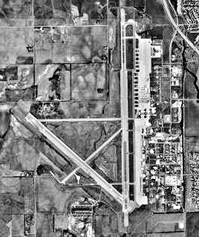 |
| USGS aerial photo as of 17 August 1991 |
| IATA: SLN â ICAO: KSLN â FAA LID: SLN |
| Summary |
| Airport type |
Public |
| Owner |
Salina Airport Authority |
| Serves |
Salina, Kansas |
| Elevation AMSL |
1,288 ft / 393 m |
| Coordinates |
38°47â²27â³N 097°39â²08â³W / 38.79083°N 97.65222°W / 38.79083; -97.65222 |
| Website |
www.SalinaAirport.com |
| Runways |
| Direction |
Length |
Surface |
| ft |
m |
| 17/35 |
12,300 |
3,749 |
Asphalt |
| 12/30 |
6,510 |
1,984 |
Asphalt |
| 18/36 |
4,300 |
1,311 |
Asphalt |
| 4/22 |
3,648 |
1,112 |
Asphalt |
| Statistics (2007) |
| Aircraft operations |
84,977 |
| Based aircraft |
137 |
| Source: Federal Aviation Administration |
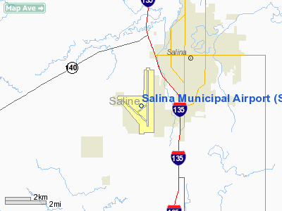
Salina Municipal Airport (IATA: SLN, ICAO: KSLN, FAA LID: SLN) is a public-use airport located three nautical miles (6 km) southwest of the central business district of Salina, a city in Saline County, Kansas, United States. It is owned by the Salina Airport Authority.
The airport is located on the site of the former Schilling Air Force Base and Smoky Hill Air Force Base. Currently it is mostly used for general aviation, but is also served by one commercial airline. Service is subsidized by the Essential Air Service program. Salina Municipal Airport is also the home of the Kansas State University - Salina flight department.
The airport was used as the takeoff and landing point for the Virgin Atlantic GlobalFlyer, flown by Steve Fossett in the first nonstop, non-refueled solo circumnavigation of the earth from February 28 to March 3, 2005. Fossett also used the airport as the takeoff and landing point for a later nonstop and nonrefueled solo circumnavigation in the GlobalFlyer from March 14 to March 17, 2006 which set a new record for greatest distance traveled by an aircraft on a closed course. History
Military useFacilities and aircraft
Salina Municipal Airport covers an area of 2,954 acres (1,195 ha) at an elevation of 1,288 feet (393 m) above mean sea level. It has four asphalt paved runways: 17/35 is 12,300 by 150 feet (3,749 x 46 m), 12/30 is 6,510 by 100 feet (1,984 x 30 m), 18/36 is 4,300 by 75 feet (1,311 x 23 m), and 4/22 is 3,648 by 75 feet (1,112 x 23 m).
For the 12-month period ending February 28, 2007, the airport had 84,977 aircraft operations, an average of 232 per day: 90% general aviation, 7% air taxi, 3% military and <1% scheduled commercial. At that time there were 137 aircraft based at this airport: 74% single-engine, 13% multi-engine, 4% jet, 3% helicopter, 2% glider and 4% military.
Airlines and destinations
| Airlines |
Destinations |
| SeaPort Airlines |
Kansas City |
The above content comes from Wikipedia and is published under free licenses – click here to read more.
|
Location &
QuickFacts
|
FAA
Information Effective: |
2008-09-25 |
|
Airport
Identifier: |
SLN |
|
Airport
Status: |
Operational |
|
Longitude/Latitude: |
097-39-07.8110W/38-47-27.4790N
-97.652170/38.790966 (Estimated) |
|
Elevation: |
1288 ft / 392.58 m (Surveyed) |
|
Land: |
2954 acres |
|
From
nearest city: |
3 nautical miles SW of Salina, KS |
|
Location: |
Saline County, KS |
|
Magnetic Variation: |
07E (1990) |
Owner & Manager
|
Ownership: |
Publicly owned |
|
Owner: |
Salina Arpt Auth |
|
Address: |
3237 Arnold
Salina, KS 67401 |
|
Phone number: |
785-827-3914 |
|
Manager: |
Mr. Timothy F Rogers |
|
Address: |
3237 Arnold
Salina, KS 67401 |
|
Phone number: |
785-827-3914 |
Airport
Operations and Facilities
|
Airport
Use: |
Open to public |
|
Wind
indicator: |
Yes |
|
Segmented Circle: |
No |
|
Control
Tower: |
Yes |
|
Lighting
Schedule: |
DUSK-DAWN
WHEN ATCT CLSD ACTVT MIRL RY 12/30; PAPI RYS 12 & 30; HIRL RY 17/35;
MALS & PAPI RY 17; MALSR RY 35 - CTAF. |
|
Beacon
Color: |
Clear-Green (lighted land airport) |
|
Landing
fee charge: |
No |
|
Sectional chart: |
Wichita |
|
Region: |
ACE - Central |
|
Boundary
ARTCC: |
ZKC - Kansas City |
|
Tie-in
FSS: |
ICT - Wichita |
|
FSS on
Airport: |
No |
|
FSS Toll
Free: |
1-800-WX-BRIEF |
|
NOTAMs
Facility: |
SLN (NOTAM-d service avaliable) |
|
Certification type/date: |
II A S 05/197
PPR 24 HRS FOR UNSKED ACR OPNS WITH MORE THAN 30 PSGR SEATS CALL AMGR
785-827-3914. ARFF AVBL MON-SUN 0600-2300. ARFF INDEX B PROVIDED. |
|
Federal Agreements: |
NGPXY |
Airport Communications
|
CTAF: |
119.300 |
|
Unicom: |
122.950 |
Airport Services
|
Fuel
available: |
100LLA MOGAS |
|
Airframe
Repair: |
MAJOR |
|
Power
Plant Repair: |
MAJOR |
|
Bottled
Oxygen: |
NONE |
|
Bulk
Oxygen: |
HIGH |
|
Runway Information
Runway 04/22
|
Dimension: |
3648 x 75 ft / 1111.9 x 22.9 m |
|
Surface: |
ASPH, Fair Condition |
|
Weight Limit: |
Single wheel: 100000 lbs.
Dual wheel: 135000 lbs.
Dual tandem wheel: 230000 lbs. |
|
|
Runway 04
|
Runway 22
|
|
Longitude: |
097-39-22.1300W |
097-38-47.4240W |
|
Latitude: |
38-47-10.2970N |
38-47-34.0050N |
|
Elevation: |
1271.00 ft |
1256.00 ft |
|
Alignment: |
49 |
127 |
|
Traffic
Pattern: |
Left |
Left |
|
Markings: |
Basic, Fair Condition |
Basic, Fair Condition |
|
Obstruction: |
, 50:1 slope to clear |
46 ft bldg, 1550.0 ft from runway, 200 ft left of
centerline, 29:1 slope to clear |
|
Runway 12/30
|
Dimension: |
6510 x 100 ft / 1984.2 x 30.5 m |
|
Surface: |
ASPH, |
|
Weight Limit: |
Single wheel: 55000 lbs.
Dual wheel: 68000 lbs.
Dual tandem wheel: 125000 lbs. |
|
Edge Lights: |
Medium |
|
|
Runway 12
|
Runway 30
|
|
Longitude: |
097-40-01.1100W |
097-39-00.3900W |
|
Latitude: |
38-47-36.8800N |
38-46-53.5100N |
|
Elevation: |
1258.00 ft |
1272.00 ft |
|
Alignment: |
127 |
127 |
|
Traffic
Pattern: |
Left |
Left |
|
Markings: |
Non-precision instrument, Good Condition |
Non-precision instrument, Good Condition |
|
Crossing
Height: |
48.00 ft |
48.00 ft |
|
VASI: |
4-light PAPI on left side |
4-light PAPI on left side |
|
Visual
Glide Angle: |
3.00° |
3.00° |
|
Obstruction: |
52 ft tree, 2284.0 ft from runway, 538 ft right of
centerline, 40:1 slope to clear |
, 50:1 slope to clear |
|
Runway 17/35
|
Dimension: |
12300 x 150 ft / 3749.0 x 45.7 m |
|
Surface: |
ASPH, |
|
Weight Limit: |
Single wheel: 75000 lbs.
Dual wheel: 200000 lbs.
Dual tandem wheel: 360000 lbs.
Dual dual tandem wheel: 600000 lbs. |
|
Edge Lights: |
High |
|
|
Runway 17
|
Runway 35
|
|
Longitude: |
097-38-45.4600W |
097-38-45.1589W |
|
Latitude: |
38-48-37.4600N |
38-46-35.8872N |
|
Elevation: |
1245.00 ft |
1271.00 ft |
|
Alignment: |
127 |
127 |
|
ILS Type: |
|
ILS |
|
Traffic
Pattern: |
Left |
Left |
|
Markings: |
Precision instrument, Good Condition |
Precision instrument, Good Condition |
|
Crossing
Height: |
52.00 ft |
0.00 ft |
|
VASI: |
4-light PAPI on left side |
|
|
Visual
Glide Angle: |
3.00° |
0.00° |
|
Approach
lights: |
MALS |
MALSR |
|
Obstruction: |
, 50:1 slope to clear |
30 ft gnd, 1375.0 ft from runway, 500 ft left of
centerline, 39:1 slope to clear |
|
Runway 18/36
|
Dimension: |
4300 x 75 ft / 1310.6 x 22.9 m |
|
Surface: |
ASPH, |
|
Weight Limit: |
Single wheel: 30000 lbs. |
|
|
Runway 18
|
Runway 36
|
|
Longitude: |
097-39-41.2880W |
097-39-41.1728W |
|
Latitude: |
38-47-37.7299N |
38-46-55.2268N |
|
Elevation: |
1254.00 ft |
1288.00 ft |
|
Alignment: |
127 |
127 |
|
Traffic
Pattern: |
Left |
Left |
|
Markings: |
Non-precision instrument, Good Condition |
Non-precision instrument, Good Condition |
|
Radio Navigation Aids
|
ID |
Type |
Name |
Ch |
Freq |
Var |
Dist |
|
MPR |
NDB |
Mc Pherson |
|
227.00 |
06E |
26.7 nm |
|
LYO |
NDB |
Lyons |
|
386.00 |
06E |
38.0 nm |
|
HRU |
NDB |
Herington |
|
407.00 |
06E |
39.9 nm |
|
CYW |
NDB |
Clay Center |
|
362.00 |
07E |
42.2 nm |
|
CVY |
NDB |
Cavalry |
|
314.00 |
06E |
42.5 nm |
|
CNK |
NDB |
Concordia |
|
335.00 |
06E |
45.8 nm |
|
EWK |
NDB |
Newton |
|
281.00 |
06E |
47.2 nm |
|
FRI |
VOR |
Fort Riley |
|
109.40 |
06E |
38.6 nm |
|
HUT |
VOR/DME |
Hutchinson |
115X |
116.80 |
09E |
49.5 nm |
|
SLN |
VORTAC |
Salina |
118X |
117.10 |
07E |
8.2 nm |
Remarks
-
NO LINE OF SIGHT,
ALL RYS DUE TO GRADIENT, TOPOGRAPHY & TREES.
-
SEASONAL MOWING
OPNS ADJ TO RYS & TWYS.
-
CALM WIND RY 35.
-
ACR OPNS
INVOLVING ACFT WITH MORE THAN 9 PSGRS SEATS ARE NOT AUTHORIZED IN EXCESS OF 15
MINS BEFORE OR AFTER SKED ARR OR DEP TIMES WITHOUT PRIOR COORD WITH AMGR TO
CONFIRM THAT ARFF SVCS ARE AVBL PRIOR TO LNDG OR TKOF.
CALL AMGR 785-827-3914.
Based Aircraft
|
Aircraft based
on field: |
119 |
|
Single Engine
Airplanes: |
89 |
|
Multi Engine
Airplanes: |
14 |
|
Jet Engine
Airplanes: |
3 |
|
Helicopters: |
5 |
|
Gliders: |
3 |
|
Military: |
5 |
Operational Statistics
Time Period: 2007-02-01 - 2008-01-31
|
Aircraft
Operations: |
206/Day |
|
Commerical: |
6.6% |
|
General
Aviation Local: |
43.4% |
|
General
Aviation Itinerant: |
43.7% |
|
Military: |
6.2% |
Salina Municipal Airport
Address:
Saline County, KS
Tel:
785-827-3914
Images
and information placed above are from
http://www.airport-data.com/airport/SLN/
We
thank them for the data!
|
General Info |
| Country |
United
States |
| State |
KANSAS
|
| FAA ID |
SLN
|
| Latitude |
38-47-29.337N |
|
Longitude |
097-39-02.172W |
|
Elevation |
1273
feet |
| Near
City |
SALINA
|
We don't guarantee the information is fresh and accurate. The data may
be wrong or outdated.
For more up-to-date information please refer to other sources.
|
|


