 |
|
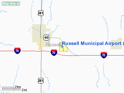
Russell Municipal Airport |
|
|
|
Location &
QuickFacts
|
FAA
Information Effective: |
2008-09-25 |
|
Airport
Identifier: |
RSL |
|
Airport
Status: |
Operational |
|
Longitude/Latitude: |
098-48-41.5803W/38-52-17.0860N
-98.811550/38.871413 (Estimated) |
|
Elevation: |
1862 ft / 567.54 m (Surveyed) |
|
Land: |
173 acres |
|
From
nearest city: |
2 nautical miles SE of Russell, KS |
|
Location: |
Russell County, KS |
|
Magnetic Variation: |
08E (1985) |
Owner & Manager
|
Ownership: |
Publicly owned |
|
Owner: |
City Of Russell |
|
Address: |
City Hall
Russell, KS 67665 |
|
Phone number: |
785-483-6311 |
|
Manager: |
Arlyn Unrein |
|
Address: |
City Hall
Russell, KS 67665 |
|
Phone number: |
785-483-6911 |
Airport
Operations and Facilities
|
Airport
Use: |
Open to public |
|
Wind
indicator: |
Yes |
|
Segmented Circle: |
Yes |
|
Control
Tower: |
No |
|
Lighting
Schedule: |
DUSK-DAWN
ACTVT MIRL RY 17/35; PAPI & REIL RYS 17 & 35 -- CTAF. |
|
Beacon
Color: |
Clear-Green (lighted land airport) |
|
Landing
fee charge: |
No |
|
Sectional chart: |
Wichita |
|
Region: |
ACE - Central |
|
Boundary
ARTCC: |
ZKC - Kansas City |
|
Tie-in
FSS: |
ICT - Wichita |
|
FSS on
Airport: |
No |
|
FSS Toll
Free: |
1-800-WX-BRIEF |
|
NOTAMs
Facility: |
RSL (NOTAM-d service avaliable) |
|
Federal Agreements: |
NGY |
Airport Communications
|
CTAF: |
122.700 |
|
Unicom: |
122.700 |
Airport Services
|
Fuel
available: |
100LL |
|
Airframe
Repair: |
MAJOR |
|
Power
Plant Repair: |
MAJOR |
|
Runway Information
Runway 03/21
|
Dimension: |
1602 x 300 ft / 488.3 x 91.4 m |
|
Surface: |
TURF, Good Condition |
|
|
Runway 03
|
Runway 21
|
|
Longitude: |
098-48-57.3590W |
098-48-42.6890W |
|
Latitude: |
38-52-17.6800N |
38-52-31.2300N |
|
Elevation: |
1856.00 ft |
1859.00 ft |
|
Alignment: |
40 |
127 |
|
Traffic
Pattern: |
Left |
Left |
|
Runway End
Identifier: |
No |
No |
|
Centerline
Lights: |
No |
No |
|
Touchdown
Lights: |
No |
No |
|
Obstruction: |
58 ft trees, 606.0 ft from runway, 148 ft left of
centerline, 10:1 slope to clear |
66 ft ant, 1185.0 ft from runway, 165 ft left of
centerline, 17:1 slope to clear |
|
Runway 17/35
|
Dimension: |
5000 x 75 ft / 1524.0 x 22.9 m |
|
Surface: |
CONC, |
|
Weight Limit: |
Single wheel: 30000 lbs.
Dual wheel: 30000 lbs. |
|
Edge Lights: |
Medium |
|
|
Runway 17
|
Runway 35
|
|
Longitude: |
098-48-42.3200W |
098-48-35.4300W |
|
Latitude: |
38-52-39.2900N |
38-51-50.1600N |
|
Elevation: |
1860.00 ft |
1862.00 ft |
|
Alignment: |
127 |
127 |
|
Traffic
Pattern: |
Left |
Left |
|
Markings: |
Non-precision instrument, Good Condition |
Non-precision instrument, Good Condition |
|
Crossing
Height: |
36.00 ft |
35.00 ft |
|
VASI: |
4-light PAPI on left side |
4-light PAPI on left side |
|
Visual
Glide Angle: |
3.00° |
3.00° |
|
Runway End
Identifier: |
Yes |
Yes |
|
Centerline
Lights: |
No |
No |
|
Touchdown
Lights: |
No |
No |
|
Obstruction: |
26 ft pline, 795.0 ft from runway, 254 ft left of
centerline, 30:1 slope to clear |
, 50:1 slope to clear |
|
Radio Navigation Aids
|
ID |
Type |
Name |
Ch |
Freq |
Var |
Dist |
|
HIL |
NDB |
Hilyn |
|
338.00 |
08E |
31.1 nm |
|
LYO |
NDB |
Lyons |
|
386.00 |
06E |
41.8 nm |
|
LQR |
NDB |
Larned |
|
296.00 |
08E |
42.1 nm |
|
HYS |
VORTAC |
Hays |
041X |
110.40 |
10E |
21.8 nm |
Top
Remarks
-
PUB PHONE ACCESS
AT ARPT.
-
CONDL: PROVIDED A
CLEAR APPROACH TO EACH RWY IS MAINTAINED FOR A MINIMUM 20:1 GLIDE SLOPE AND
THE TRANSITIONAL SURFACE BE MAINTAINED FOR A 7:1 SLOPE.
Based Aircraft
|
Aircraft based
on field: |
16 |
|
Single Engine
Airplanes: |
13 |
|
Multi Engine
Airplanes: |
1 |
|
Helicopters: |
1 |
|
Ultralights: |
1 |
Operational Statistics
Time Period: 2006-08-22 - 2007-08-21
|
Aircraft
Operations: |
231/Week |
|
General
Aviation Local: |
50.0% |
|
General
Aviation Itinerant: |
50.0% |
|
Military: |
0.1% |
Russell Municipal Airport
Address:
Russell County, KS
Tel:
785-483-6311
Images
and information placed above are from
http://www.airport-data.com/airport/RSL/
We
thank them for the data!
|
General Info |
| Country |
United
States |
| State |
KANSAS
|
| FAA ID |
RSL
|
| Latitude |
38-52-19.640N |
|
Longitude |
098-48-42.394W |
|
Elevation |
1862
feet |
| Near
City |
RUSSELL
|
We don't guarantee the information is fresh and accurate. The data may
be wrong or outdated.
For more up-to-date information please refer to other sources.
|
|


