Robinson Industries Heliport |
|
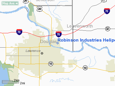
Location &
QuickFacts
|
FAA
Information Effective: |
2008-09-25 |
|
Airport
Identifier: |
04KS |
|
Airport
Status: |
Operational |
|
Longitude/Latitude: |
095-13-10.8990W/38-58-44.0070N
-95.219694/38.978891 (Estimated) |
|
Elevation: |
835 ft / 254.51 m (Estimated) |
|
Land: |
0 acres |
|
From
nearest city: |
0 nautical miles N of Lawrence, KS |
|
Location: |
Douglas County, KS |
|
Magnetic Variation: |
05E (1985) |
Owner & Manager
|
Ownership: |
Privately owned |
|
Owner: |
James W Robinson |
|
Address: |
827 Maple St
Lawrence, KS 66044 |
|
Phone number: |
913-843-8062 |
|
Address: |
|
Airport
Operations and Facilities
|
Airport
Use: |
Private |
|
Wind
indicator: |
No |
|
Segmented Circle: |
No |
|
Control
Tower: |
No |
|
Landing
fee charge: |
No |
|
Sectional chart: |
Kansas City |
|
Region: |
ACE - Central |
|
Boundary
ARTCC: |
ZKC - Kansas City |
|
Tie-in
FSS: |
ICT - Wichita |
|
FSS on
Airport: |
No |
|
FSS Toll
Free: |
1-800-WX-BRIEF |
|
Runway Information
Helipad H1
|
Dimension: |
400 x 60 ft / 121.9 x 18.3 m |
|
Surface: |
TURF-GRVL, |
|
|
Runway H1
|
Runway
|
|
Traffic
Pattern: |
Left |
Left |
|
Radio Navigation Aids
|
ID |
Type |
Name |
Ch |
Freq |
Var |
Dist |
|
TO |
NDB |
Biloy |
|
521.00 |
05E |
23.4 nm |
|
DO |
NDB |
Dotte |
|
359.00 |
05E |
26.3 nm |
|
GQ |
NDB |
Norge |
|
517.00 |
05E |
26.8 nm |
|
GKB |
NDB |
Norge |
|
517.00 |
05E |
26.8 nm |
|
LXT |
NDB |
Lesumit |
|
263.00 |
04E |
39.6 nm |
|
UKL |
NDB |
Boyd |
|
245.00 |
05E |
47.1 nm |
|
GPH |
NDB |
Mosby |
|
284.00 |
03E |
47.9 nm |
|
FOE |
TACAN |
Forbes |
053X |
|
05E |
20.7 nm |
|
OJC |
VOR/DME |
Johnson County |
077X |
113.00 |
06E |
24.1 nm |
|
RIS |
VOR/DME |
Riverside |
051X |
111.40 |
05E |
30.3 nm |
|
TOP |
VORTAC |
Topeka |
125X |
117.80 |
05E |
18.1 nm |
|
MCI |
VORTAC |
Kansas City |
079Y |
113.25 |
05E |
29.1 nm |
|
FOE |
VOT |
Forbes |
|
111.00 |
|
21.0 nm |
|
MKC |
VOT |
Kansas City Downtown |
|
108.60 |
|
30.3 nm |
Remarks
-
PRVDD TKOFS TO &
APCHS FROM NORTH ARE PROHIBITED &. APCH/DEP PATHS TO LNDG AREA ARE MAINTD FOR
MIN 8:1 GLIDE SLOPE & TRSNL SFC BE MAINTD FOR MIN 2:1 SLOPE.
Based Aircraft
|
Aircraft based
on field: |
1 |
|
Helicopters: |
1 |
Robinson Industries Heliport
Address:
Douglas County, KS
Tel:
913-843-8062
Images
and information placed above are from
http://www.airport-data.com/airport/04KS/
We
thank them for the data!
|
General Info |
| Country |
United
States |
| State |
KANSAS
|
| FAA ID |
04KS
|
| Latitude |
38-58-44.007N |
|
Longitude |
095-13-10.899W |
|
Elevation |
835 feet
|
| Near
City |
LAWRENCE
|
We don't guarantee the information is fresh and accurate. The data may
be wrong or outdated.
For more up-to-date information please refer to other sources.
|


