 |
|
Renner Field /goodland Municipal/ Airport |
Goodland Municipal Airport
Renner Field |
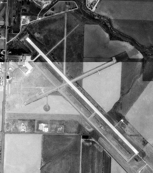 |
| USGS aerial image, 28 August 1991 |
| IATA: GLD â ICAO: KGLD â FAA LID: GLD |
| Summary |
| Airport type |
Public |
| Owner |
City of Goodland |
| Serves |
Goodland, Kansas |
| Elevation AMSL |
3,656 ft / 1,114 m |
| Coordinates |
39°22â²14â³N 101°41â²56â³W / 39.37056°N 101.69889°W / 39.37056; -101.69889 |
| Runways |
| Direction |
Length |
Surface |
| ft |
m |
| 12/30 |
5,499 |
1,676 |
Concrete |
| 5/23 |
3,501 |
1,067 |
Asphalt |
| 17/35 |
1,800 |
549 |
Turf |
| Statistics (2007) |
| Aircraft operations |
43,000 |
| Based aircraft |
22 |
| Source: Federal Aviation Administration |
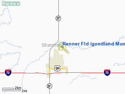
Goodland Municipal Airport (IATA: GLD, ICAO: KGLD, FAA LID: GLD) is a city-owned public-use airport located two nautical miles (3.7 km) north of the central business district of Goodland, a city in Sherman County, Kansas, United States. It is also known as Renner Field. Facilities and aircraft
Goodland Municipal Airport covers an area of 372 acres (151 ha) at an elevation of 3,656 feet (1,114 m) above mean sea level. It has three runways: 12/30 is 5,499 by 100 feet (1,676 x 30 m) with an concrete surface; 5/23 is 3,501 by 75 feet (1,067 x 23 m) with an asphalt surface; 17/35 is 1,800 by 40 feet (549 x 12 m) with an turf surface.
For the 12-month period ending July 16, 2007, the airport had 43,000 aircraft operations, an average of 117 per day: 98% general aviation, 1% air taxi and 1% military. At that time there were 22 aircraft based at this airport: 77% single-engine and 23% multi-engine.
History
Provided contract glider training to the United States Army Air Forces, 1942-1943. Training provided by William A. Ong under AAFTC 22d Glider Training Detachment. Used primarily C-47 Skytrains and Waco CG-4 unpowered Gliders. Training began on 8 June 1942. The mission of the school was to train glider pilot students in proficiency in operation of gliders in various types of towed and soaring flight, both day and night, and in servicing of gliders in the field.
During wartime use, the airport had four compacted soil runways; aligned N/S; NE/SW; E/W and NW/SE, all approximately 2,800' long with NE/SW 3,600' long. Former NW/SE runway now paved and used as main, others still visible in aerial photography. Training ended on 29 August 1943 due to shortage of equipment. Glider training mission was taken over by I Troop Carrier Command, and the airport was used as an axillary airfield until the end of the war. Was returned to civil control in September 1945.
The above content comes from Wikipedia and is published under free licenses – click here to read more.
|
Location &
QuickFacts
|
FAA
Information Effective: |
2008-09-25 |
|
Airport
Identifier: |
GLD |
|
Airport
Status: |
Operational |
|
Longitude/Latitude: |
101-41-56.3710W/39-22-14.2390N
-101.698992/39.370622 (Estimated) |
|
Elevation: |
3656 ft / 1114.35 m (Surveyed) |
|
Land: |
372 acres |
|
From
nearest city: |
2 nautical miles N of Goodland, KS |
|
Location: |
Sherman County, KS |
|
Magnetic Variation: |
09E (1985) |
Owner & Manager
|
Ownership: |
Publicly owned |
|
Owner: |
City Of Goodland |
|
Address: |
Mr> Wayne Hill , City Manager, P. O. Box 57
Goodland, KS 67735 |
|
Phone
number: |
785-890-4500 |
|
Manager: |
Mr. John Collett
CITY MANAGER. |
|
Address: |
Butterfly Aviation, Renner Municiple Airport
Goodland, KS 67735 |
|
Phone number: |
785-890-7531 |
Airport Operations and Facilities
|
Airport
Use: |
Open to public |
|
Wind
indicator: |
Yes |
|
Segmented Circle: |
No |
|
Control
Tower: |
No |
|
Lighting
Schedule: |
DUSK-DAWN
ACTVT MIRL RYS 05/23 & 12/30; MALSR RY 30; REIL RY 12; AND PAPI RYS 05
& 23 - CTAF. |
|
Beacon
Color: |
Clear-Green (lighted land airport) |
|
Landing
fee charge: |
No |
|
Sectional chart: |
Wichita |
|
Region: |
ACE - Central |
|
Boundary
ARTCC: |
ZDV - Denver |
|
Tie-in
FSS: |
ICT - Wichita |
|
FSS on
Airport: |
No |
|
FSS Toll
Free: |
1-800-WX-BRIEF |
|
NOTAMs
Facility: |
GLD (NOTAM-d service avaliable) |
|
Federal Agreements: |
NGY |
Airport Communications
|
CTAF: |
122.950 |
|
Unicom: |
122.950 |
Airport Services
|
Fuel
available: |
100LLA |
|
Airframe
Repair: |
MAJOR |
|
Power
Plant Repair: |
MAJOR |
|
Bottled
Oxygen: |
NONE |
|
Bulk
Oxygen: |
LOW |
|
Runway Information
Runway 05/23
|
Dimension: |
3501 x 75 ft / 1067.1 x 22.9 m |
|
Surface: |
ASPH, Good Condition |
|
Weight Limit: |
Single wheel: 12500 lbs. |
|
Edge Lights: |
Medium |
|
|
Runway 05
|
Runway 23
|
|
Longitude: |
101-42-18.5930W |
101-41-38.8540W |
|
Latitude: |
39-22-06.6630N |
39-22-22.3340N |
|
Elevation: |
3656.00 ft |
3637.00 ft |
|
Alignment: |
63 |
127 |
|
Traffic
Pattern: |
Left |
Left |
|
Markings: |
Basic, Good Condition |
Basic, Good Condition |
|
Crossing
Height: |
37.00 ft |
41.00 ft |
|
VASI: |
4-light PAPI on left side
PAPI UNUSBL BYD 8 DEGS LEFT OF CNTRLN. |
4-light PAPI on left side |
|
Visual
Glide Angle: |
3.00° |
3.00° |
|
Obstruction: |
27 ft road, 718.0 ft from runway, 3780 ft left of
centerline, 19:1 slope to clear |
, 50:1 slope to clear
FENCE CORNER 4' AT 190' FROM THR; 100L CENTERLINE. |
|
Runway 12/30
|
Dimension: |
5499 x 100 ft / 1676.1 x 30.5 m |
|
Surface: |
CONC, Good Condition |
|
Weight Limit: |
Single wheel: 30000 lbs.
Dual wheel: 48000 lbs. |
|
Edge Lights: |
Medium |
|
|
Runway 12
|
Runway 30
|
|
Longitude: |
101-42-18.2760W |
101-41-28.2290W |
|
Latitude: |
39-22-28.9970N |
39-21-50.9980N |
|
Elevation: |
3644.00 ft |
3652.00 ft |
|
Alignment: |
127 |
127 |
|
ILS Type: |
|
ILS/DME |
|
Traffic
Pattern: |
Left |
Left |
|
Markings: |
Precision instrument, Good Condition |
Precision instrument, Good Condition |
|
Approach
lights: |
|
MALSR |
|
Runway End
Identifier: |
Yes |
|
|
Obstruction: |
6 ft bldg, 425.0 ft from runway, 500 ft left of
centerline, 37:1 slope to clear |
|
|
Runway 17/35
|
Dimension: |
1800 x 40 ft / 548.6 x 12.2 m |
|
Surface: |
TURF, Good Condition |
|
|
Runway 17
|
Runway 35
|
|
Longitude: |
101-42-01.3740W |
101-42-01.2870W |
|
Latitude: |
39-22-35.5840N |
39-22-17.7960N |
|
Alignment: |
127 |
127 |
|
Traffic
Pattern: |
Left |
Left |
|
Radio Navigation Aids
|
ID |
Type |
Name |
Ch |
Freq |
Var |
Dist |
|
GL |
NDB |
Shugr |
|
414.00 |
09E |
6.5 nm |
|
SYF |
NDB |
St Francis |
|
386.00 |
10E |
21.6 nm |
|
ITR |
NDB |
Kit Carson |
|
209.00 |
10E |
28.2 nm |
|
JDM |
NDB |
Wheatfield |
|
408.00 |
08E |
31.4 nm |
|
ADT |
NDB |
Atwood |
|
365.00 |
09E |
41.3 nm |
|
OEL |
NDB |
Oakley |
|
380.00 |
08E |
44.0 nm |
|
GLD |
VORTAC |
Goodland |
098X |
115.10 |
12E |
1.1 nm |
Remarks
-
ONLY TWY A2 AVBL
FOR ACFT OVER 12500 LBS.
-
RY 23 TURNAROUND
DOES NOT HAVE ADEQUATE CLNC FOR HOLDING.
-
RY 30 CALM WIND RWY.
Based Aircraft
|
Aircraft based
on field: |
22 |
|
Single Engine
Airplanes: |
17 |
|
Multi Engine
Airplanes: |
5 |
Operational Statistics
Time Period: 2006-07-17 - 2007-07-16
|
Aircraft
Operations: |
118/Day |
|
Air Taxi: |
0.9% |
|
General
Aviation Local: |
23.3% |
|
General
Aviation Itinerant: |
74.4% |
|
Military: |
1.4% |
Renner Field /goodland Municipal/
Airport
Address:
Sherman County, KS
Tel:
785-890-4500,
785-890-7531
Images
and information placed above are from
http://www.airport-data.com/airport/GLD/
We
thank them for the data!
|
General Info |
| Country |
United
States |
| State |
KANSAS
|
| FAA ID |
GLD
|
| Latitude |
39-22-14.239N |
|
Longitude |
101-41-56.371W |
|
Elevation |
3656
feet |
| Near
City |
GOODLAND
|
We don't guarantee the information is fresh and accurate. The data may
be wrong or outdated.
For more up-to-date information please refer to other sources.
|
|


