 |
|
|
|
|
|
|
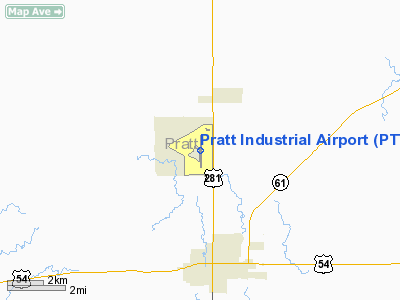
Location &
QuickFacts
|
FAA
Information Effective: |
2008-09-25 |
|
Airport
Identifier: |
PTT |
|
Airport
Status: |
Operational |
|
Longitude/Latitude: |
098-44-49.2000W/37-42-09.1000N
-98.747000/37.702528 (Estimated) |
|
Elevation: |
1953 ft / 595.27 m (Surveyed) |
|
Land: |
2569 acres |
|
From
nearest city: |
4 nautical miles N of Pratt, KS |
|
Location: |
Pratt County, KS |
|
Magnetic Variation: |
07E (1990) |
Owner & Manager
|
Ownership: |
Publicly owned |
|
Owner: |
Pratt Airport Authority |
|
Address: |
Box 867
Pratt, KS 67124 |
|
Phone number: |
620-672-7571 |
|
Manager: |
Reid Bell |
|
Address: |
Po Box 867
Pratt, KS 67124 |
|
Phone number: |
620-672-7571 |
Airport
Operations and Facilities
|
Airport
Use: |
Open to public |
|
Wind
indicator: |
Yes |
|
Segmented Circle: |
No |
|
Control
Tower: |
No |
|
Lighting
Schedule: |
DUSK-DAWN
MIRL RY 17/35 PRESET ON LOW INTST; TO INCR INTST ACTVT - CTAF.
FOR PAPI RYS 17 & 35 DURG DALGT HRS ACTVT - CTAF. |
|
Beacon
Color: |
Clear-Green (lighted land airport) |
|
Landing
fee charge: |
No |
|
Sectional chart: |
Wichita |
|
Region: |
ACE - Central |
|
Boundary
ARTCC: |
ZKC - Kansas City |
|
Tie-in
FSS: |
ICT - Wichita |
|
FSS on
Airport: |
No |
|
FSS Toll
Free: |
1-800-WX-BRIEF |
|
NOTAMs
Facility: |
PTT (NOTAM-d service avaliable) |
|
Federal Agreements: |
NGPY |
Airport Communications
|
CTAF: |
122.800 |
|
Unicom: |
122.800 |
Airport Services
|
Fuel
available: |
100LLA |
|
Airframe
Repair: |
MAJOR |
|
Power
Plant Repair: |
MAJOR |
|
Bottled
Oxygen: |
NONE |
|
Bulk
Oxygen: |
NONE |
|
Runway Information
Runway 17/35
|
Dimension: |
5500 x 100 ft / 1676.4 x 30.5 m |
|
Surface: |
CONC, Good Condition |
|
Weight Limit: |
Single wheel: 30000 lbs.
Dual wheel: 42000 lbs. |
|
Edge Lights: |
Medium |
|
|
Runway 17
|
Runway 35
|
|
Longitude: |
098-44-49.3048W |
098-44-49.1657W |
|
Latitude: |
37-42-36.3322N |
37-41-41.9624N |
|
Elevation: |
1951.00 ft |
1945.00 ft |
|
Alignment: |
127 |
0 |
|
Traffic
Pattern: |
Left |
Left |
|
Markings: |
Non-precision instrument, Good Condition |
Non-precision instrument, Good Condition |
|
Crossing
Height: |
40.00 ft |
40.00 ft |
|
VASI: |
4-light PAPI on left side |
4-light PAPI on left side |
|
Visual
Glide Angle: |
3.00° |
3.00° |
|
Runway End
Identifier: |
Yes |
Yes |
|
Radio Navigation Aids
|
ID |
Type |
Name |
Ch |
Freq |
Var |
Dist |
|
PTT |
NDB |
Pratt |
|
356.00 |
07E |
1.3 nm |
|
LQR |
NDB |
Larned |
|
296.00 |
08E |
34.2 nm |
|
HIL |
NDB |
Hilyn |
|
338.00 |
08E |
40.1 nm |
|
LYO |
NDB |
Lyons |
|
386.00 |
06E |
45.9 nm |
|
HUT |
VOR/DME |
Hutchinson |
115X |
116.80 |
09E |
42.4 nm |
|
ANY |
VORTAC |
Anthony |
076X |
112.90 |
07E |
42.7 nm |
Remarks
-
DO NOT MISTAKE
LGTD CATTLE PENS FOR LGTD RYS.
-
ULTRA-LIGHTS &
GYRO-COPTERS USE R TFC RY 17/35 NOT TO EXCEED 500 FT AGL.
-
RY 17 IS CALM
WIND RY.
-
WATCH FOR
MIGRATING BIRDS ON & INVOF ARPT.
Based Aircraft
|
Aircraft based
on field: |
25 |
|
Single Engine
Airplanes: |
17 |
|
Multi Engine
Airplanes: |
8 |
Operational Statistics
Time Period: 2007-08-15 - 2008-08-13
|
Aircraft
Operations: |
221/Week |
|
Air Taxi: |
2.6% |
|
General
Aviation Local: |
62.9% |
|
General
Aviation Itinerant: |
33.2% |
|
Military: |
1.3% |
Pratt Industrial Airport
Address:
Pratt County, KS
Tel:
620-672-7571
Images
and information placed above are from
http://www.airport-data.com/airport/PTT/
We
thank them for the data!
|
General Info |
| Country |
United
States |
| State |
KANSAS
|
| FAA ID |
PTT
|
| Latitude |
37-42-00.063N |
|
Longitude |
098-44-46.329W |
|
Elevation |
1952
feet |
| Near
City |
PRATT
|
We don't guarantee the information is fresh and accurate. The data may
be wrong or outdated.
For more up-to-date information please refer to other sources.
|
|


