 |
|
|
Location &
QuickFacts
|
FAA
Information Effective: |
2008-09-25 |
|
Airport
Identifier: |
8KS8 |
|
Airport
Status: |
Operational |
|
Longitude/Latitude: |
097-00-28.0500W/38-55-04.0000N
-97.007792/38.917778 (Estimated) |
|
Elevation: |
1222 ft / 372.47 m (Estimated) |
|
Land: |
80 acres |
|
From
nearest city: |
4 nautical miles S of Chapman, KS |
|
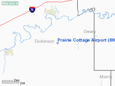
Location: |
Dickinson County, KS |
|
Magnetic Variation: |
06E (1995) |
Owner & Manager
|
Ownership: |
Privately owned |
|
Owner: |
Jim & Debby Clark |
|
Address: |
2071-2200 Ave
Chapman, KS 67431 |
|
Phone number: |
785-922-7029 |
|
Manager: |
Jim & Debby Clark |
|
Address: |
2071-2200 Ave
Chapman, KS 67431 |
|
Phone number: |
785-210-7500 |
Airport
Operations and Facilities
|
Airport
Use: |
Private |
|
Wind
indicator: |
Yes
WINDSOCK |
|
Segmented Circle: |
No |
|
Control
Tower: |
No |
|
Sectional chart: |
Wichita |
|
Region: |
ACE - Central |
|
Boundary
ARTCC: |
ZKC - Kansas City |
|
Tie-in
FSS: |
ICT - Wichita |
|
FSS on
Airport: |
No |
|
FSS Toll
Free: |
1-800-WX-BRIEF |
|
Runway Information
Runway 05/23
|
Dimension: |
1400 x 60 ft / 426.7 x 18.3 m |
|
Surface: |
, |
|
|
Runway 05
|
Runway 23
|
|
Traffic
Pattern: |
Left |
Left |
|
Runway 18/36
|
Dimension: |
2400 x 60 ft / 731.5 x 18.3 m |
|
Surface: |
TURF, |
|
|
Runway 18
|
Runway 36
|
|
Traffic
Pattern: |
Left |
Left |
|
Radio Navigation Aids
|
ID |
Type |
Name |
Ch |
Freq |
Var |
Dist |
|
CVY |
NDB |
Cavalry |
|
314.00 |
06E |
11.9 nm |
|
HRU |
NDB |
Herington |
|
407.00 |
06E |
16.4 nm |
|
MQD |
NDB |
Mc Dowell Creek |
|
391.00 |
06E |
21.4 nm |
|
CYW |
NDB |
Clay Center |
|
362.00 |
07E |
28.7 nm |
|
MPR |
NDB |
Mc Pherson |
|
227.00 |
06E |
46.8 nm |
|
CNK |
NDB |
Concordia |
|
335.00 |
06E |
48.5 nm |
|
FRI |
VOR |
Fort Riley |
|
109.40 |
06E |
7.6 nm |
|
MHK |
VOR/DME |
Manhattan |
039X |
110.20 |
06E |
20.9 nm |
|
SLN |
VORTAC |
Salina |
118X |
117.10 |
07E |
28.7 nm |
Based Aircraft
|
Aircraft based
on field: |
3 |
|
Single Engine
Airplanes: |
3 |
Prairie Cottage Airport
Address:
Dickinson County, KS
Tel:
785-922-7029, 785-210-7500
Images
and information placed above are from
http://www.airport-data.com/airport/8KS8/
We
thank them for the data!
|
General Info |
| Country |
United
States |
| State |
KANSAS
|
| FAA ID |
8KS8
|
| Latitude |
38-55-04.000N |
|
Longitude |
097-00-28.050W |
|
Elevation |
1222
feet |
| Near
City |
CHAPMAN
|
We don't guarantee the information is fresh and accurate. The data may
be wrong or outdated.
For more up-to-date information please refer to other sources.
|
|


