 |
|
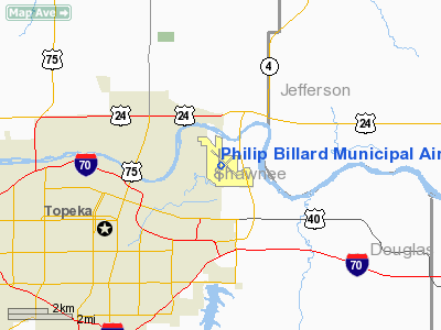
Philip Billard Municipal Airport |
| Philip Billard Municipal Airport |
| IATA: TOP â ICAO: KTOP â FAA LID: TOP |
| Summary |
| Airport type |
Public |
| Owner |
Metropolitan Topeka Airport Authority |
| Location |
Topeka, Kansas |
| Elevation AMSL |
881 ft / 269 m |
| Coordinates |
39°04â²07â³N 095°37â²21â³W / 39.06861°N 95.6225°W / 39.06861; -95.6225 |
| Runways |
| Direction |
Length |
Surface |
| ft |
m |
| 4/22 |
3,002 |
915 |
Asphalt |
| 13/31 |
5,099 |
1,554 |
Asphalt |
| 18/36 |
4,331 |
1,320 |
Asphalt |
| Statistics (2004) |
| Aircraft operations |
65,800 |
| Based aircraft |
88 |
| Source: Federal Aviation Administration |
Philip Billard Municipal Airport (IATA: TOP, ICAO: KTOP, FAA LID: TOP) is a public airport located three miles (5 km) northeast of the central business district of Topeka, the capital city of the U.S. state of Kansas and the county seat of Shawnee County. This airport is publicly owned by the Metropolitan Topeka Airport Authority.
Facilities and aircraft
Philip Billard Municipal Airport covers an area of 920 acres (372 ha) which contains three runways:
- Runway 4/22: 3,002 x 100 ft (915 x 30 m), Surface: Asphalt
- Runway 13/31: 5,099 x 100 ft (1,554 x 30 m), Surface: Asphalt
- Runway 18/36: 4,331 x 75 ft (1,320 x 23 m), Surface: Asphalt
For 12-month period ending 31 December 2004 the airport had 65,800 aircraft operations, an average of 180 per day: 96% general aviation, 3% military and 2% air taxi. There are 88 aircraft based at this airport: 78% single engine, 11% multi-engine (10), 6% helicopters, 3% ultralights and 1% jet aircraft.
The above content comes from Wikipedia and is published under free licenses – click here to read more.
|
Location &
QuickFacts
|
FAA
Information Effective: |
2008-09-25 |
|
Airport
Identifier: |
TOP |
|
Airport
Status: |
Operational |
|
Longitude/Latitude: |
095-37-20.9410W/39-04-07.1670N
-95.622484/39.068657 (Estimated) |
|
Elevation: |
881 ft / 268.53 m (Surveyed) |
|
Land: |
920 acres |
|
From
nearest city: |
3 nautical miles NE of Topeka, KS |
|
Location: |
Shawnee County, KS |
|
Magnetic Variation: |
05E (2000) |
Owner & Manager
|
Ownership: |
Publicly owned |
|
Owner: |
Metro. Topeka Arpt Auth. |
|
Address: |
Forbes Field, B-19053
Topeka, KS 66619 |
|
Phone
number: |
785-862-2362 |
|
Manager: |
Michael R. Humberd |
|
Address: |
Forbes Field, Po Box 19053
Topeka, KS 66619 |
|
Phone number: |
785-862-2362 |
Airport Operations and Facilities
|
Airport
Use: |
Open to public |
|
Wind
indicator: |
Yes |
|
Segmented Circle: |
No |
|
Control
Tower: |
Yes |
|
Lighting
Schedule: |
DUSK-DAWN
WHEN ATCT CLSD MIRL RYS 04/22 & 18/36 & HIRL RY 13/31 PRESET ON LOW
INTST; TO INCR INTST & ACTVT MALSR RY 13; VASI RYS 18; 31; 36 & REIL
RYS 18 & 31 - CTAF. |
|
Beacon
Color: |
Clear-Green (lighted land airport) |
|
Landing
fee charge: |
No |
|
Sectional chart: |
Kansas City |
|
Region: |
ACE - Central |
|
Traffic
Pattern Alt: |
800 ft |
|
Boundary
ARTCC: |
ZKC - Kansas City |
|
Tie-in
FSS: |
ICT - Wichita |
|
FSS on
Airport: |
No |
|
FSS Toll
Free: |
1-800-WX-BRIEF |
|
NOTAMs
Facility: |
TOP (NOTAM-d service avaliable) |
|
Federal Agreements: |
NGVY3 |
Airport Communications
|
CTAF: |
118.700 |
|
Unicom: |
122.950
MULTICOM - 121.900. |
Airport Services
|
Fuel
available: |
100LLA |
|
Airframe
Repair: |
MAJOR |
|
Power
Plant Repair: |
MAJOR |
|
Bottled
Oxygen: |
NONE |
|
Bulk
Oxygen: |
NONE |
|
Runway Information
Runway 04/22
|
Dimension: |
3002 x 100 ft / 915.0 x 30.5 m |
|
Surface: |
ASPH, Fair Condition |
|
Weight Limit: |
Single wheel: 29000 lbs. |
|
Edge Lights: |
Medium |
|
|
Runway 04
|
Runway 22
|
|
Longitude: |
095-37-36.6040W |
095-37-07.8330W |
|
Latitude: |
39-03-55.5550N |
39-04-14.9780N |
|
Elevation: |
878.00 ft |
879.00 ft |
|
Alignment: |
49 |
127 |
|
Traffic
Pattern: |
Left |
Left |
|
Markings: |
Basic, Fair Condition |
Basic, Fair Condition |
|
Obstruction: |
98 ft tree, 2757.0 ft from runway, 10 ft right of
centerline, 26:1 slope to clear |
33 ft tree, 1152.0 ft from runway, 525 ft right of
centerline, 28:1 slope to clear |
|
Runway 13/31
|
Dimension: |
5099 x 100 ft / 1554.2 x 30.5 m |
|
Surface: |
ASPH, Good Condition |
|
Weight Limit: |
Single wheel: 50000 lbs.
Dual wheel: 72000 lbs.
Dual tandem wheel: 110000 lbs. |
|
Edge Lights: |
High |
|
|
Runway 13
|
Runway 31
|
|
Longitude: |
095-37-37.3470W |
095-36-51.1070W |
|
Latitude: |
39-04-29.2420N |
39-03-54.0210N |
|
Elevation: |
880.00 ft |
875.00 ft |
|
Alignment: |
127 |
127 |
|
ILS Type: |
ILS |
|
|
Traffic
Pattern: |
Left |
Left |
|
Markings: |
Precision instrument, Good Condition |
Precision instrument, Good Condition |
|
Crossing
Height: |
0.00 ft |
55.00 ft |
|
VASI: |
|
4-box on left side |
|
Visual
Glide Angle: |
0.00° |
3.00° |
|
Approach
lights: |
MALSR |
|
|
Runway End
Identifier: |
|
Yes |
|
Obstruction: |
41 ft tree, 1482.0 ft from runway, 651 ft right of
centerline, 31:1 slope to clear |
31 ft tree, 286.0 ft from runway, 306 ft right of
centerline, 2:1 slope to clear |
|
Runway 18/36
|
Dimension: |
4331 x 75 ft / 1320.1 x 22.9 m |
|
Surface: |
ASPH, Good Condition |
|
Weight Limit: |
Single wheel: 60000 lbs.
Dual wheel: 80000 lbs.
Dual tandem wheel: 96000 lbs. |
|
Edge Lights: |
Medium |
|
|
Runway 18
|
Runway 36
|
|
Longitude: |
095-37-27.1660W |
095-37-28.7580W |
|
Latitude: |
39-04-24.6180N |
39-03-41.8340N |
|
Elevation: |
880.00 ft |
880.00 ft |
|
Alignment: |
127 |
2 |
|
Traffic
Pattern: |
Left |
Left |
|
Markings: |
Non-precision instrument, Poor Condition
MKGS BADLY FADED. |
Non-precision instrument, Poor Condition
MKGS BADLY FADED. |
|
Crossing
Height: |
41.00 ft |
38.00 ft |
|
VASI: |
4-box on left side |
4-box on right side |
|
Visual
Glide Angle: |
3.00° |
3.00° |
|
Runway End
Identifier: |
Yes |
|
|
Obstruction: |
68 ft trees, 2901.0 ft from runway, 39:1 slope to clear |
34 ft trees, 657.0 ft from runway, 188 ft right of
centerline, 13:1 slope to clear |
|
Radio Navigation Aids
|
ID |
Type |
Name |
Ch |
Freq |
Var |
Dist |
|
TO |
NDB |
Biloy |
|
521.00 |
05E |
4.3 nm |
|
DO |
NDB |
Dotte |
|
359.00 |
05E |
41.7 nm |
|
GQ |
NDB |
Norge |
|
517.00 |
05E |
45.1 nm |
|
GKB |
NDB |
Norge |
|
517.00 |
05E |
45.1 nm |
|
UKL |
NDB |
Boyd |
|
245.00 |
05E |
46.5 nm |
|
MQD |
NDB |
Mc Dowell Creek |
|
391.00 |
06E |
47.1 nm |
|
FOE |
TACAN |
Forbes |
053X |
|
05E |
7.5 nm |
|
OJC |
VOR/DME |
Johnson County |
077X |
113.00 |
06E |
43.6 nm |
|
RBA |
VOR/DME |
Robinson |
019X |
108.20 |
04E |
47.9 nm |
|
RIS |
VOR/DME |
Riverside |
051X |
111.40 |
05E |
48.0 nm |
|
MHK |
VOR/DME |
Manhattan |
039X |
110.20 |
06E |
49.0 nm |
|
TOP |
VORTAC |
Topeka |
125X |
117.80 |
05E |
5.4 nm |
|
MCI |
VORTAC |
Kansas City |
079Y |
113.25 |
05E |
43.3 nm |
|
FOE |
VOT |
Forbes |
|
111.00 |
|
7.3 nm |
|
MKC |
VOT |
Kansas City Downtown |
|
108.60 |
|
47.9 nm |
Remarks
-
APU - 12/24 VOLT.
-
LARGE & SMALL
MIGRATORY BIRDS ON & INVOF ARPT.
-
ULTRALIGHT ACTVTY
ON & INVOF ARPT.
-
ULTRALIGHTS MUST
MAINTAIN RDO CONTACT AT ALL TIMES.
Based Aircraft
|
Aircraft based
on field: |
62 |
|
Single Engine
Airplanes: |
56 |
|
Multi Engine
Airplanes: |
3 |
|
Ultralights: |
3 |
Operational Statistics
Time Period: 2006-09-01 - 2007-08-31
|
Aircraft
Operations: |
176/Day |
|
Air Taxi: |
2.9% |
|
General
Aviation Local: |
38.4% |
|
General
Aviation Itinerant: |
56.4% |
|
Military: |
2.3% |
Philip Billard Municipal Airport
Address:
Shawnee County, KS
Tel:
785-862-2362
Images
and information placed above are from
http://www.airport-data.com/airport/TOP/
We
thank them for the data!
|
General Info |
| Country |
United
States |
| State |
KANSAS
|
| FAA ID |
TOP
|
| Latitude |
39-04-07.167N |
|
Longitude |
095-37-20.941W |
|
Elevation |
881 feet
|
| Near
City |
TOPEKA
|
We don't guarantee the information is fresh and accurate. The data may
be wrong or outdated.
For more up-to-date information please refer to other sources.
|
|


