 |
|
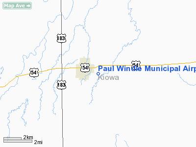
Paul Windle Municipal Airport |
| Paul Windle Municipal Airport |
| IATA: none â ICAO: none â FAA LID: 8K7 |
| Summary |
| Airport type |
Public |
| Owner |
City of Greensburg |
| Serves |
Greensburg, Kansas |
| Elevation AMSL |
2,230 ft / 680 m |
| Coordinates |
37°36â²16â³N 099°16â²23â³W / 37.60444°N 99.27306°W / 37.60444; -99.27306 |
| Runways |
| Direction |
Length |
Surface |
| ft |
m |
| 2/20 |
2,600 |
792 |
Turf |
| 17/35 |
2,400 |
732 |
Turf |
| Statistics (2008) |
| Aircraft operations |
3,700 |
| Source: FAA, with corrected coordinates from WikiMapia |
Paul Windle Municipal Airport (FAA LID: 8K7) is a public use airport located east of the central business district of Greensburg, a city in Kiowa County, Kansas, United States. The airport is owned by the City of Greensburg and named in honor of Capt. Paul R. "Windy" Windle (1934-1965) who learned to fly at this airport and was killed in action during the Vietnam War.
Facilities and aircraft
Paul Windle Municipal Airport covers an area of 71 acres (29 ha) at an elevation of 2,230 feet (680 m) above mean sea level. It has two runways with turf surfaces: 2/20 is 2,600 by 130 feet (792 x 40 m) and 17/35 is 2,400 by 290 feet (732 x 88 m). For the 12-month period ending August 13, 2008, the airport had 3,700 general aviation aircraft operations, an average of 10 per day.
The above content comes from Wikipedia and is published under free licenses – click here to read more.
|
Location &
QuickFacts
|
FAA
Information Effective: |
2008-09-25 |
|
Airport
Identifier: |
8K7 |
|
Airport
Status: |
Operational |
|
Longitude/Latitude: |
099-16-30.4050W/37-36-00.0660N
-99.275113/37.600018 (Estimated) |
|
Elevation: |
2230 ft / 679.70 m (Surveyed) |
|
Land: |
71 acres |
|
From
nearest city: |
0 nautical miles E of Greensburg, KS |
|
Location: |
Kiowa County, KS |
|
Magnetic Variation: |
08E (1985) |
Owner & Manager
|
Ownership: |
Publicly owned |
|
Owner: |
City Of Greensburg |
|
Address: |
239 S. Main
Greensburg, KS 67054 |
|
Phone number: |
620-723-2751 |
|
Manager: |
Steve Hewitt |
|
Address: |
239 South Main
Greensburg, KS 67054 |
|
Phone number: |
620-723-2691 |
Airport
Operations and Facilities
|
Airport
Use: |
Open to public |
|
Wind
indicator: |
Yes |
|
Segmented Circle: |
No |
|
Control
Tower: |
No |
|
Lighting
Schedule: |
RDO-CTL
ACTVT LIRL RY 17/35 - CTAF. |
|
Landing
fee charge: |
No |
|
Sectional chart: |
Wichita |
|
Region: |
ACE - Central |
|
Boundary
ARTCC: |
ZKC - Kansas City |
|
Tie-in
FSS: |
ICT - Wichita |
|
FSS on
Airport: |
No |
|
FSS Toll
Free: |
1-800-WX-BRIEF |
|
NOTAMs
Facility: |
ICT (NOTAM-d service avaliable) |
Airport Communications
Airport Services
|
Airframe
Repair: |
NONE |
|
Power
Plant Repair: |
NONE |
|
Runway Information
Runway 02/20
|
Dimension: |
2600 x 130 ft / 792.5 x 39.6 m
MKD BY MOWING. |
|
Surface: |
TURF, Good Condition |
|
|
Runway 02
|
Runway 20
|
|
Traffic
Pattern: |
Left |
Left |
|
Obstruction: |
15 ft road, 50.0 ft from runway, 3:1 slope to clear |
18 ft road, 75.0 ft from runway, 4:1 slope to clear |
|
Runway 17/35
|
Dimension: |
2400 x 290 ft / 731.5 x 88.4 m
MKD BY MOWING. |
|
Surface: |
TURF, Good Condition |
|
Edge Lights: |
Non-standard lighting system
ONLY S 2125 FT LGTD. |
|
|
Runway 17
|
Runway 35
|
|
Traffic
Pattern: |
Left |
Left |
|
Displaced
threshold: |
275.00 ft
DSPLCD THLD MARKED WITH ORANGE METAL 'A' FRAMES. |
0.00 ft |
|
Obstruction: |
18 ft road, 60.0 ft from runway, 3:1 slope to clear
APCH RATIO FROM DSPLCD THR 18:1. |
15 ft road, 30.0 ft from runway, 2:1 slope to clear |
|
Radio Navigation Aids
|
ID |
Type |
Name |
Ch |
Freq |
Var |
Dist |
|
PTT |
NDB |
Pratt |
|
356.00 |
07E |
26.2 nm |
|
LQR |
NDB |
Larned |
|
296.00 |
08E |
37.4 nm |
|
BFK |
NDB |
Buffalo |
|
215.00 |
08E |
47.2 nm |
|
HIL |
NDB |
Hilyn |
|
338.00 |
08E |
48.9 nm |
|
DDC |
VORTAC |
Dodge City |
019X |
108.20 |
08E |
37.9 nm |
Remarks
-
ARPT CONSTRUCTED PRIOR TO
1959.
Based Aircraft
|
Aircraft based
on field: |
2 |
|
Single Engine
Airplanes: |
1 |
|
Ultralights: |
1 |
Operational Statistics
Time Period: 2007-08-15 - 2008-08-13
|
Aircraft
Operations: |
72/Week |
|
General
Aviation Local: |
59.5% |
|
General
Aviation Itinerant: |
40.5% |
Paul Windle Municipal Airport
Address:
Kiowa County, KS
Tel:
620-723-2751, 620-723-2691
Images
and information placed above are from
http://www.airport-data.com/airport/8K7/
We
thank them for the data!
|
General Info |
| Country |
United
States |
| State |
KANSAS
|
| FAA ID |
8K7
|
| Latitude |
37-36-00.066N |
|
Longitude |
099-16-30.405W |
|
Elevation |
2230
feet |
| Near
City |
GREENSBURG |
We don't guarantee the information is fresh and accurate. The data may
be wrong or outdated.
For more up-to-date information please refer to other sources.
|
|


