 |
|
|
|
|
|
|
Location &
QuickFacts
|
FAA
Information Effective: |
2008-09-25 |
|
Airport
Identifier: |
OWI |
|
Airport
Status: |
Operational |
|
Longitude/Latitude: |
095-15-10.7000W/38-32-19.2000N
-95.252972/38.538667 (Estimated) |
|
Elevation: |
966 ft / 294.44 m (Surveyed) |
|
Land: |
280 acres |
|
From
nearest city: |
4 nautical miles S of Ottawa, KS |
|
Location: |
Franklin County, KS |
|
Magnetic Variation: |
04E (2000) |
Owner & Manager
|
Ownership: |
Publicly owned |
|
Owner: |
City Of Ottawa |
|
Address: |
101 S Hickory
Ottawa, KS 66067 |
|
Phone number: |
785-229-3630 |
|
Manager: |
Charles Le Master |
|
Address: |
2178 Montana Rd
Ottawa, KS 66067 |
|
Phone number: |
785-242-5310 |
Airport
Operations and Facilities
|
Airport
Use: |
Open to public |
|
Wind
indicator: |
Yes
WIND SOCK FADED |
|
Segmented Circle: |
No |
|
Control
Tower: |
No |
|
Lighting
Schedule: |
DUSK-DAWN
MIRL RY 17/35 PRESET ON LOW INTST; TO INCR INTST AND ACTVT REIL RY 35
- CTAF. |
|
Beacon
Color: |
Clear-Green (lighted land airport) |
|
Landing
fee charge: |
No |
|
Sectional chart: |
Kansas City |
|
Region: |
ACE - Central |
|
Boundary
ARTCC: |
ZKC - Kansas City |
|
Tie-in
FSS: |
ICT - Wichita |
|
FSS on
Airport: |
No |
|
FSS Toll
Free: |
1-800-WX-BRIEF |
|
NOTAMs
Facility: |
ICT (NOTAM-d service avaliable) |
|
Federal Agreements: |
NGY |
Airport Communications
|
CTAF: |
122.800 |
|
Unicom: |
122.800 |
Airport Services
|
Fuel
available: |
100LL |
|
Airframe
Repair: |
NONE |
|
Power
Plant Repair: |
NONE |
|
Bottled
Oxygen: |
NONE |
|
Bulk
Oxygen: |
NONE |
|
Runway Information
Runway 05/23
|
Dimension: |
2345 x 81 ft / 714.8 x 24.7 m |
|
Surface: |
TURF, Poor Condition
UNEVEN / ROUGH GRASS SURFACE
UNEVEN / ROUGH GRASS SURFACE |
|
|
Runway 05
|
Runway 23
|
|
Longitude: |
095-15-21.9040W |
095-15-00.4040W |
|
Latitude: |
38-32-10.5490N |
38-32-24.0480N |
|
Elevation: |
962.00 ft |
962.00 ft |
|
Traffic
Pattern: |
Left |
Left |
|
Obstruction: |
, 50:1 slope to clear |
22 ft road, 231.0 ft from runway, 10:1 slope to clear |
|
Runway 13/31
|
Dimension: |
1785 x 72 ft / 544.1 x 21.9 m |
|
Surface: |
TURF, Poor Condition
UNEVEN / ROUGH GRASS SURFACE
UNEVEN / ROUGH GRASS SURFACE |
|
|
Runway 13
|
Runway 31
|
|
Longitude: |
095-15-24.4100W |
095-15-07.5000W |
|
Latitude: |
38-32-22.6100N |
38-32-11.0000N |
|
Elevation: |
958.00 ft |
961.00 ft |
|
Alignment: |
127 |
127 |
|
Traffic
Pattern: |
Left |
Left |
|
Obstruction: |
27 ft tree, 738.0 ft from runway, 20 ft right of
centerline, 27:1 slope to clear |
58 ft pline, 1440.0 ft from runway, 24:1 slope to clear |
|
Runway 17/35
|
Dimension: |
4500 x 75 ft / 1371.6 x 22.9 m |
|
Surface: |
ASPH, Fair Condition
UNEVEN / ROUGH GRASS SURFACE
UNEVEN / ROUGH GRASS SURFACE |
|
Weight Limit: |
Single wheel: 25000 lbs.
Dual wheel: 30000 lbs. |
|
Edge Lights: |
Medium |
|
|
Runway 17
|
Runway 35
|
|
Longitude: |
095-15-07.6600W |
095-15-07.4600W |
|
Latitude: |
38-32-44.2900N |
38-31-59.8100N |
|
Elevation: |
964.00 ft |
964.00 ft |
|
Alignment: |
127 |
127 |
|
Traffic
Pattern: |
Left |
Left |
|
Markings: |
Non-precision instrument, Good Condition |
Non-precision instrument, Good Condition |
|
Runway End
Identifier: |
|
Yes |
|
Obstruction: |
90 ft tree, 1560.0 ft from runway, 400 ft right of
centerline, 15:1 slope to clear |
, 50:1 slope to clear |
|
Radio Navigation Aids
|
ID |
Type |
Name |
Ch |
Freq |
Var |
Dist |
|
UKL |
NDB |
Boyd |
|
245.00 |
05E |
26.3 nm |
|
TO |
NDB |
Biloy |
|
521.00 |
05E |
40.4 nm |
|
GQ |
NDB |
Norge |
|
517.00 |
05E |
42.1 nm |
|
GKB |
NDB |
Norge |
|
517.00 |
05E |
42.1 nm |
|
MSB |
NDB |
Monarch |
|
410.00 |
04E |
45.6 nm |
|
DO |
NDB |
Dotte |
|
359.00 |
05E |
47.3 nm |
|
LXT |
NDB |
Lesumit |
|
263.00 |
04E |
48.5 nm |
|
FOE |
TACAN |
Forbes |
053X |
|
05E |
31.1 nm |
|
OJC |
VOR/DME |
Johnson County |
077X |
113.00 |
06E |
30.3 nm |
|
RIS |
VOR/DME |
Riverside |
051X |
111.40 |
05E |
46.6 nm |
|
TOP |
VORTAC |
Topeka |
125X |
117.80 |
05E |
38.6 nm |
|
BUM |
VORTAC |
Butler |
106X |
115.90 |
07E |
39.4 nm |
|
EMP |
VORTAC |
Emporia |
075X |
112.80 |
08E |
44.3 nm |
|
FOE |
VOT |
Forbes |
|
111.00 |
|
31.5 nm |
|
MKC |
VOT |
Kansas City Downtown |
|
108.60 |
|
46.6 nm |
Remarks
-
ULTRALIGHT &
GLIDER ACTIVITY ON & INVOF ARPT.
-
TWYS MKD WITH
BLUE REFLECTORS.
-
CLSD CHRISTMAS DAY.
-
+75 FT POLES 1700
FT N OF AER 17 MKD W/RED LGTS. PLINE MKD W/RED BALLS.
-
WILDLIFE ON & INVOF ARPT
Based Aircraft
|
Aircraft based
on field: |
49 |
|
Single Engine
Airplanes: |
29 |
|
Multi Engine
Airplanes: |
11 |
|
Jet Engine
Airplanes: |
5 |
|
Ultralights: |
4 |
Operational Statistics
Time Period: 2004-09-17 - 2005-09-16
|
Aircraft
Operations: |
83/Week |
|
Air Taxi: |
3.7% |
|
General
Aviation Local: |
46.4% |
|
General
Aviation Itinerant: |
46.4% |
|
Military: |
3.5% |
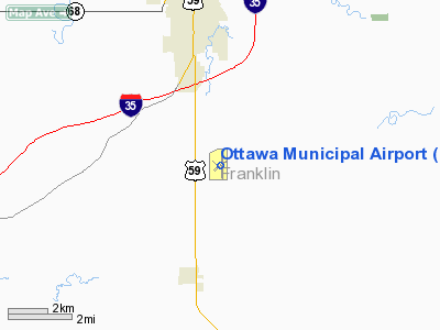
Ottawa Municipal Airport
Address:
Franklin County, KS
Tel:
785-229-3630, 785-242-5310
Images
and information placed above are from
http://www.airport-data.com/airport/OWI/
We
thank them for the data!
|
General Info |
| Country |
United
States |
| State |
KANSAS
|
| FAA ID |
OWI
|
| Latitude |
38-32-19.200N |
|
Longitude |
095-15-10.700W |
|
Elevation |
966 feet
|
| Near
City |
OTTAWA
|
We don't guarantee the information is fresh and accurate. The data may
be wrong or outdated.
For more up-to-date information please refer to other sources.
|
|


