 |
|
|
|
|
|
|
Location &
QuickFacts
|
FAA
Information Effective: |
2008-09-25 |
|
Airport
Identifier: |
OEL |
|
Airport
Status: |
Operational |
|
Longitude/Latitude: |
100-49-00.0520W/39-06-42.4302N
-100.816681/39.111786 (Estimated) |
|
Elevation: |
3045 ft / 928.12 m (Surveyed) |
|
Land: |
282 acres |
|
From
nearest city: |
2 nautical miles SE of Oakley, KS |
|
Location: |
Logan County, KS |
|
Magnetic Variation: |
08E (1995) |
Owner & Manager
|
Ownership: |
Publicly owned |
|
Owner: |
City Of Oakley |
|
Address: |
City Hall
Oakley, KS 67748 |
|
Phone number: |
785-672-3136 |
|
Manager: |
John Lysinger |
|
Address: |
210 Airport Drive
Oakley, KS 67748-6016 |
|
Phone number: |
785-672-4621 |
Airport
Operations and Facilities
|
Airport
Use: |
Open to public |
|
Wind
indicator: |
Yes |
|
Segmented Circle: |
Yes |
|
Control
Tower: |
No |
|
Lighting
Schedule: |
DUSK-DAWN
MIRL RY 16/34 PRESET LOW INTST DUSK-2230; TO INCR INTST - CTAF; AFTER
2230 ACTVT MIRL RY 16/34 - CTAF.
KEY MIKE
5 TIMES - LOW; 7 TIMES - MED & 9 TIMES - HIGH. |
|
Beacon
Color: |
Clear-Green (lighted land airport) |
|
Landing
fee charge: |
No |
|
Sectional chart: |
Wichita |
|
Region: |
ACE - Central |
|
Boundary
ARTCC: |
ZDV - Denver |
|
Tie-in
FSS: |
ICT - Wichita |
|
FSS on
Airport: |
No |
|
FSS Toll
Free: |
1-800-WX-BRIEF |
|
NOTAMs
Facility: |
ICT (NOTAM-d service avaliable) |
|
Federal Agreements: |
NGY |
Airport Communications
|
CTAF: |
122.800 |
|
Unicom: |
122.800 |
Airport Services
|
Fuel
available: |
100LL
FOR FUEL AFTER HRS CALL 785-672-4111. |
|
Airframe
Repair: |
MAJOR |
|
Power
Plant Repair: |
MAJOR |
|
Bottled
Oxygen: |
NONE |
|
Bulk
Oxygen: |
NONE |
|
Runway Information
Runway 08/26
|
Dimension: |
2270 x 110 ft / 691.9 x 33.5 m |
|
Surface: |
TURF, Good Condition
SEVERE JOINT SEPERATION ENTIRE RY. |
|
|
Runway 08
|
Runway 26
|
|
Traffic
Pattern: |
Left |
Left |
|
Obstruction: |
450 ft ant, 10000.0 ft from runway, 22:1 slope to clear |
15 ft road, 320.0 ft from runway, 21:1 slope to clear |
|
Runway 16/34
|
Dimension: |
5000 x 75 ft / 1524.0 x 22.9 m |
|
Surface: |
ASPH, Poor Condition
SEVERE JOINT SEPERATION ENTIRE RY. |
|
Weight Limit: |
Single wheel: 12500 lbs. |
|
Edge Lights: |
Medium |
|
|
Runway 16
|
Runway 34
|
|
Longitude: |
100-49-05.2389W |
100-48-53.0713W |
|
Latitude: |
39-07-00.0489N |
39-06-11.5566N |
|
Elevation: |
3045.00 ft |
3019.00 ft |
|
Alignment: |
127 |
127 |
|
Traffic
Pattern: |
Left |
Left |
|
Markings: |
Numbers only, Poor Condition
RWY 16 MARKINGS FADED. |
Non-precision instrument, Fair Condition |
|
Radio Navigation Aids
|
ID |
Type |
Name |
Ch |
Freq |
Var |
Dist |
|
JDM |
NDB |
Wheatfield |
|
408.00 |
08E |
26.3 nm |
|
GL |
NDB |
Shugr |
|
414.00 |
09E |
38.1 nm |
|
TQK |
NDB |
Scott City |
|
256.00 |
08E |
38.1 nm |
|
ADT |
NDB |
Atwood |
|
365.00 |
09E |
45.0 nm |
|
OIN |
NDB |
Oberlin |
|
341.00 |
09E |
45.1 nm |
|
HLC |
VORTAC |
Hill City |
084X |
113.70 |
08E |
28.9 nm |
|
GLD |
VORTAC |
Goodland |
098X |
115.10 |
12E |
44.0 nm |
Remarks
Based Aircraft
|
Aircraft based
on field: |
11 |
|
Single Engine
Airplanes: |
8 |
|
Multi Engine
Airplanes: |
2 |
|
Jet Engine
Airplanes: |
1 |
Operational Statistics
Time Period: 2006-07-24 - 2007-07-23
|
Aircraft
Operations: |
235/Week |
|
Air Taxi: |
0.8% |
|
General
Aviation Local: |
57.4% |
|
General
Aviation Itinerant: |
41.8% |
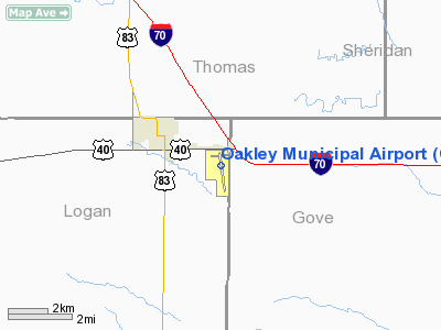
Oakley Municipal Airport
Address:
Logan County, KS
Tel:
785-672-3136, 785-672-4621
Images
and information placed above are from
http://www.airport-data.com/airport/OEL/
We
thank them for the data!
|
General Info |
| Country |
United
States |
| State |
KANSAS
|
| FAA ID |
OEL
|
| Latitude |
39-06-35.800N |
|
Longitude |
100-48-59.200W |
|
Elevation |
3045
feet |
| Near
City |
OAKLEY
|
We don't guarantee the information is fresh and accurate. The data may
be wrong or outdated.
For more up-to-date information please refer to other sources.
|
|


