 |
|
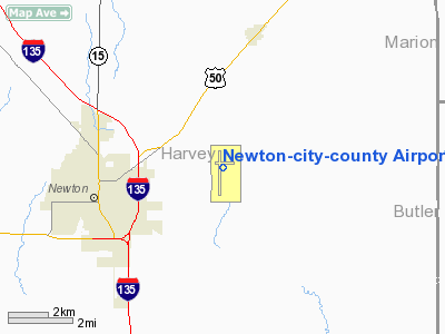
Newton-city-county Airport |
| Newton City/County Airport |
| IATA: EWK â ICAO: KEWK â FAA LID: EWK |
| Summary |
| Airport type |
Public |
| Owner |
City of Newton & Harvey County |
| Serves |
Newton, Kansas |
| Elevation AMSL |
1,533 ft / 467 m |
| Coordinates |
38°03â²30â³N 097°16â²28â³W / 38.05833°N 97.27444°W / 38.05833; -97.27444 |
| Runways |
| Direction |
Length |
Surface |
| ft |
m |
| 17/35 |
7,003 |
2,135 |
Asphalt |
| 8/26 |
3,501 |
1,067 |
Asphalt |
| Statistics (2007) |
| Aircraft operations |
65,044 |
| Based aircraft |
111 |
| Source: Federal Aviation Administration |
Newton City/County Airport (IATA: EWK, ICAO: KEWK, FAA LID: EWK) is a public airport located three miles (5 km) east of the central business district of Newton, a city in Harvey County, Kansas, United States. It is owned by the City of Newton and Harvey County. Newton is a designated reliever airport for Wichita Mid-Continent Airport.
Facilities and aircraft
The airport covers 635 acres (257 ha) and has two asphalt paved runways. The larger 17/35 north-south runway measures 7,003 x 100 ft. (2,135 x 30 m) and the alternate 8/26 east-west runway measures 3,501 x 60 ft. (1,067 x 18 m).
The Hesston College Aviation Program operates out of Hangar K.
For the 12-month period ending July 24, 2007, the airport had 65,044 aircraft operations, an average of 178 per day: 99% general aviation, 1% air taxi and <1% military. At that time there were 111 aircraft based at this airport: 78% single-engine, 13% multi-engine, 7% jet, 1% helicopter and 1% ultralight.
The above content comes from Wikipedia and is published under free licenses – click here to read more.
|
Location &
QuickFacts
|
FAA
Information Effective: |
2008-09-25 |
|
Airport
Identifier: |
EWK |
|
Airport
Status: |
Operational |
|
Longitude/Latitude: |
097-16-28.2600W/38-03-29.6200N
-97.274517/38.058228 (Estimated) |
|
Elevation: |
1533 ft / 467.26 m (Surveyed) |
|
Land: |
635 acres |
|
From
nearest city: |
3 nautical miles E of Newton, KS |
|
Location: |
Harvey County, KS |
|
Magnetic Variation: |
06E (2000) |
Owner & Manager
|
Ownership: |
Publicly owned |
|
Owner: |
City Of Newton Harvey Co |
|
Address: |
810 N. Oliver Road - Box 426
Newton, KS 67114 |
|
Phone
number: |
316-284-6089 |
|
Manager: |
T.w. Anderson |
|
Address: |
P.o. Box 426
Newton, KS 67114 |
|
Phone number: |
316-284-6084 |
Airport Operations and Facilities
|
Airport
Use: |
Open to public |
|
Wind
indicator: |
Yes |
|
Segmented Circle: |
No |
|
Control
Tower: |
No |
|
Lighting
Schedule: |
DUSK-DAWN
ACTVT HIRL,VASI RYS 17 & 35; PAPI RYS 08 & 26; REIL RYS 08; 26; & 35
AND MALSR RY 17 - CTAF. |
|
Beacon
Color: |
Clear-Green (lighted land airport) |
|
Landing
fee charge: |
No |
|
Sectional chart: |
Wichita |
|
Region: |
ACE - Central |
|
Boundary
ARTCC: |
ZKC - Kansas City |
|
Tie-in
FSS: |
ICT - Wichita |
|
FSS on
Airport: |
No |
|
FSS Toll
Free: |
1-800-WX-BRIEF |
|
NOTAMs
Facility: |
EWK (NOTAM-d service avaliable) |
|
Federal Agreements: |
NGPY |
Airport Communications
|
CTAF: |
123.000 |
|
Unicom: |
123.000 |
Airport Services
|
Fuel
available: |
100LLA MOGAS |
|
Airframe
Repair: |
MAJOR |
|
Power
Plant Repair: |
MAJOR |
|
Bottled
Oxygen: |
NONE |
|
Bulk
Oxygen: |
LOW |
|
Runway Information
Runway 08/26
|
Dimension: |
3501 x 60 ft / 1067.1 x 18.3 m
RWY 08/26 60' WIDE ASPHALT |
|
Surface: |
ASPH, Good Condition
100' WIDE ASPHALT. |
|
Weight Limit: |
Single wheel: 13000 lbs. |
|
Edge Lights: |
Medium |
|
|
Runway 08
|
Runway 26
|
|
Longitude: |
097-16-44.3600W |
097-16-00.6000W |
|
Latitude: |
38-03-38.7500N |
38-03-38.2500N |
|
Elevation: |
1532.00 ft |
1533.00 ft |
|
Alignment: |
90 |
127 |
|
Traffic
Pattern: |
Left |
Left |
|
Markings: |
Basic, Good Condition |
Basic, Good Condition |
|
Crossing
Height: |
29.00 ft |
29.00 ft |
|
VASI: |
4-light PAPI on left side |
4-light PAPI on left side |
|
Visual
Glide Angle: |
3.00° |
3.00° |
|
Runway End
Identifier: |
Yes |
Yes |
|
Decleard
distances: |
Take off run available 3501.00 ft
Take off distance available 3501.00 ft
Actual stop distance available 3501.00 ft
Landing distance available 3501.00 ft |
Take off run available 3501.00 ft
Take off distance available 3501.00 ft
Actual stop distance available 3501.00 ft
Landing distance available 3501.00 ft |
|
Runway 17/35
|
Dimension: |
7003 x 100 ft / 2134.5 x 30.5 m
RWY 08/26 60' WIDE ASPHALT |
|
Surface: |
ASPH, Good Condition
100' WIDE ASPHALT. |
|
Weight Limit: |
Single wheel: 50000 lbs.
Dual wheel: 75000 lbs.
Dual tandem wheel: 135000 lbs. |
|
Edge Lights: |
High |
|
|
Runway 17
|
Runway 35
|
|
Longitude: |
097-16-34.9900W |
097-16-34.9900W |
|
Latitude: |
38-03-53.5900N |
38-02-44.3600N |
|
Elevation: |
1529.00 ft |
1524.00 ft |
|
Alignment: |
127 |
0 |
|
ILS Type: |
ILS |
|
|
Traffic
Pattern: |
Left |
Left |
|
Markings: |
Precision instrument, Good Condition |
Non-precision instrument, Good Condition |
|
Crossing
Height: |
55.00 ft |
50.00 ft |
|
VASI: |
4-box on left side |
4-box on left side |
|
Visual
Glide Angle: |
3.00° |
3.00° |
|
Approach
lights: |
MALSR |
|
|
Runway End
Identifier: |
|
Yes |
|
Decleard
distances: |
Take off run available 7003.00 ft
Take off distance available 7003.00 ft
Actual stop distance available 6705.00 ft
Landing distance available 6705.00 ft |
Take off run available 7003.00 ft
Take off distance available 7003.00 ft
Actual stop distance available 7003.00 ft
Landing distance available 7003.00 ft |
|
Radio Navigation Aids
|
ID |
Type |
Name |
Ch |
Freq |
Var |
Dist |
|
EWK |
NDB |
Newton |
|
281.00 |
06E |
0.4 nm |
|
MPR |
NDB |
Mc Pherson |
|
227.00 |
06E |
26.2 nm |
|
EQA |
NDB |
El Dorado |
|
383.00 |
05E |
27.4 nm |
|
IC |
NDB |
Piche |
|
332.00 |
07E |
30.1 nm |
|
HRU |
NDB |
Herington |
|
407.00 |
06E |
44.0 nm |
|
EGT |
NDB |
Wellington |
|
414.00 |
07E |
44.5 nm |
|
LYO |
NDB |
Lyons |
|
386.00 |
06E |
48.2 nm |
|
IAB |
TACAN |
Mc Connell |
112X |
|
07E |
26.2 nm |
|
HUT |
VOR/DME |
Hutchinson |
115X |
116.80 |
09E |
31.4 nm |
|
ICT |
VORTAC |
Wichita |
085X |
113.80 |
07E |
23.9 nm |
|
ICT |
VOT |
Wichita |
|
114.00 |
|
26.4 nm |
Remarks
-
TOUCHDOWN AREA OF
RY 26 IS NOT VISIBLE FRM TOUCHDOWN AREA OF EITHER RY 17 OR RY 35.
-
SELF-SERVE AIRCRAFT WASH BAY
-
PROVIDED A CLEAR
APPROACH TO EACH RWY IS MAINTAINED FOR A MINIMUM 20:1 GLIDE SLOPE AND THE
TRANSITIONAL SURFACE IS MAINTAINED FOR A 7:1 SLOPE.
Based Aircraft
|
Aircraft based
on field: |
99 |
|
Single Engine
Airplanes: |
76 |
|
Multi Engine
Airplanes: |
13 |
|
Jet Engine
Airplanes: |
7 |
|
Helicopters: |
2 |
|
Ultralights: |
1 |
Operational Statistics
Time Period: 2007-06-12 - 2008-06-10
|
Aircraft
Operations: |
179/Day |
|
Air Taxi: |
1.1% |
|
General
Aviation Local: |
59.2% |
|
General
Aviation Itinerant: |
39.5% |
|
Military: |
0.2% |
Newton-city-county Airport
Address:
Harvey County, KS
Tel:
316-284-6089,
316-284-6084
Images
and information placed above are from
http://www.airport-data.com/airport/EWK/
We
thank them for the data!
|
General Info |
| Country |
United
States |
| State |
KANSAS
|
| FAA ID |
EWK
|
| Latitude |
38-03-25.579N |
|
Longitude |
097-16-30.823W |
|
Elevation |
1533
feet |
| Near
City |
NEWTON
|
We don't guarantee the information is fresh and accurate. The data may
be wrong or outdated.
For more up-to-date information please refer to other sources.
|
|


