 |
|
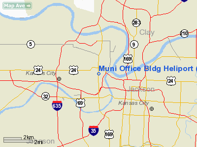
Municipal Office Building Heliport |
|
|
|
Location &
QuickFacts
|
FAA
Information Effective: |
2008-09-25 |
|
Airport
Identifier: |
SN79 |
|
Airport
Status: |
Operational |
|
Longitude/Latitude: |
094-37-33.8450W/39-06-47.0150N
-94.626068/39.113060 (Estimated) |
|
Elevation: |
1026 ft / 312.72 m (Estimated) |
|
Land: |
0 acres |
|
From
nearest city: |
0 nautical miles N of Kansas City, KS |
|
Location: |
Wyandotte County, KS |
|
Magnetic Variation: |
05E (1985) |
Owner & Manager
|
Ownership: |
Publicly owned |
|
Owner: |
City Of Kansas City |
|
Address: |
1 Civic Center Plaza
Kansas City, KS 66101 |
|
Phone
number: |
913-573-6070 |
|
Manager: |
Maurice J. Lawson/ac Mgmt |
|
Address: |
1 Civic Center Plaza
Kansas City, KS 66101 |
|
Phone number: |
913-573-5333 |
Airport Operations and Facilities
|
Airport Use: |
Private |
|
Wind indicator: |
Yes |
|
Segmented Circle: |
No |
|
Control Tower: |
No |
|
Landing fee charge: |
No |
|
Sectional chart: |
Kansas City |
|
Region: |
ACE - Central |
|
Boundary ARTCC: |
ZKC - Kansas City |
|
Tie-in FSS: |
COU - Columbia |
|
FSS on Airport: |
No |
|
FSS Toll Free: |
1-800-WX-BRIEF |
Airport Services
|
Airframe
Repair: |
NONE |
|
Power
Plant Repair: |
NONE |
|
Runway Information
Helipad H1
|
Dimension: |
75 x 65 ft / 22.9 x 19.8 m |
|
Surface: |
ASPH,
ROOFTOP HELIPORT(ATOP CITY HALL). |
|
|
Runway H1
|
Runway
|
|
Traffic
Pattern: |
Left |
Left |
|
Radio Navigation Aids
|
ID |
Type |
Name |
Ch |
Freq |
Var |
Dist |
|
GKB |
NDB |
Norge |
|
517.00 |
05E |
3.4 nm |
|
GQ |
NDB |
Norge |
|
517.00 |
05E |
3.4 nm |
|
DO |
NDB |
Dotte |
|
359.00 |
05E |
8.7 nm |
|
LXT |
NDB |
Lesumit |
|
263.00 |
04E |
15.0 nm |
|
GPH |
NDB |
Mosby |
|
284.00 |
03E |
20.4 nm |
|
EZZ |
NDB |
Cameron |
|
394.00 |
03E |
40.5 nm |
|
AZN |
NDB |
Amazon |
|
233.00 |
06E |
48.1 nm |
|
TO |
NDB |
Biloy |
|
521.00 |
05E |
49.5 nm |
|
FOE |
TACAN |
Forbes |
053X |
|
05E |
49.3 nm |
|
RIS |
VOR/DME |
Riverside |
051X |
111.40 |
05E |
1.4 nm |
|
OJC |
VOR/DME |
Johnson County |
077X |
113.00 |
06E |
17.2 nm |
|
BQS |
VOR/DME |
Braymer |
049X |
111.20 |
03E |
46.7 nm |
|
MCI |
VORTAC |
Kansas City |
079Y |
113.25 |
05E |
11.6 nm |
|
ANX |
VORTAC |
Napoleon |
087X |
114.00 |
07E |
23.2 nm |
|
TOP |
VORTAC |
Topeka |
125X |
117.80 |
05E |
43.1 nm |
|
MKC |
VOT |
Kansas City Downtown |
|
108.60 |
|
1.4 nm |
|
FOE |
VOT |
Forbes |
|
111.00 |
|
49.6 nm |
Based Aircraft
|
Aircraft based
on field: |
2 |
|
Helicopters: |
2 |
Municipal Office Building
Heliport
Address:
Wyandotte County, KS
Tel:
913-573-6070,
913-573-5333
Images
and information placed above are from
http://www.airport-data.com/airport/SN79/
We
thank them for the data!
|
General Info |
| Country |
United
States |
| State |
KANSAS
|
| FAA ID |
SN79
|
| Latitude |
39-06-47.015N |
|
Longitude |
094-37-33.845W |
|
Elevation |
1026
feet |
| Near
City |
KANSAS
CITY |
We don't guarantee the information is fresh and accurate. The data may
be wrong or outdated.
For more up-to-date information please refer to other sources.
|
|


