 |
|
Coordinates: 39°28â²16â³N 098°07â²43â³W / 39.47111°N 98.12861°W / 39.47111; -98.12861
| Moritz Memorial Airport |
| IATA: none â ICAO: none â FAA LID: K61 |
| Summary |
| Airport type |
Public |
| Owner |
City of Beloit |
| Serves |
Beloit, Kansas |
| Elevation AMSL |
1,416 ft / 432 m |
| Runways |
| Direction |
Length |
Surface |
| ft |
m |
| 04/22 |
2,381 |
726 |
Turf |
| 08/26 |
1,658 |
505 |
Turf |
| 17/35 |
3,610 |
1100 |
Concrete |
| Statistics (2008) |
| Aircraft operations |
20,000 |
| Based aircraft |
13 |
| Source: Federal Aviation Administration |
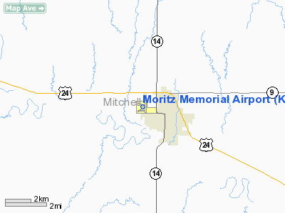
Moritz Memorial Airport (FAA LID: K61) is a city-owned public-use airport located one mile (2 km) northwest of the central business district of Beloit, a city in Mitchell County, Kansas, United States.
Facilities and aircraft
Moritz Memorial Airport covers an area of 200 acres (81 ha) which contains three runways: 04/22 with a 2,281 x 110 ft (726 x 34 m) turf surface, 08/26 with a 1,658 x 90 ft (505 x 27m) turf surface, and 17/35 with a 3,610 x 60 ft (1100 x 18 m) concrete surface.
For the 12-month period ending May 20, 2008, the airport had 20,000 general aviation aircraft operations, an average of 55 per day. At that time there were 13 aircraft based at this airport: 100% single-engine.
The above content comes from Wikipedia and is published under free licenses – click here to read more.
|
Location &
QuickFacts
|
FAA
Information Effective: |
2008-09-25 |
|
Airport
Identifier: |
K61 |
|
Airport
Status: |
Operational |
|
Longitude/Latitude: |
098-07-43.6220W/39-28-16.1480N
-98.128784/39.471152 (Estimated) |
|
Elevation: |
1416 ft / 431.60 m (Surveyed) |
|
Land: |
200 acres |
|
From
nearest city: |
1 nautical miles NW of Beloit, KS |
|
Location: |
Mitchell County, KS |
|
Magnetic Variation: |
07E (1985) |
Owner & Manager
|
Ownership: |
Publicly owned |
|
Owner: |
City Of Beloit |
|
Address: |
Municipal Bldg
Beloit, KS 67420 |
|
Phone
number: |
785-738-3551 |
|
Manager: |
Travis Lattin Fbo |
|
Address: |
Moritz Memorial Arpt Rr 3
Beloit, KS 67420 |
|
Phone number: |
785-738-7437 |
Airport Operations and Facilities
|
Airport
Use: |
Open to public |
|
Wind
indicator: |
Yes |
|
Segmented Circle: |
Yes |
|
Control
Tower: |
No |
|
Lighting
Schedule: |
DUSK-DAWN |
|
Beacon
Color: |
Clear-Green (lighted land airport) |
|
Landing
fee charge: |
No |
|
Sectional chart: |
Wichita |
|
Region: |
ACE - Central |
|
Boundary
ARTCC: |
ZKC - Kansas City |
|
Tie-in
FSS: |
ICT - Wichita |
|
FSS on
Airport: |
No |
|
FSS Toll
Free: |
1-800-WX-BRIEF |
|
NOTAMs
Facility: |
ICT (NOTAM-d service avaliable) |
|
Federal Agreements: |
NGY |
Airport Communications
|
CTAF: |
122.800 |
|
Unicom: |
122.800 |
Airport Services
|
Fuel
available: |
100LL
FOR FUEL AFTER HRS CALL 785-738-7437. |
|
Airframe
Repair: |
MAJOR |
|
Power
Plant Repair: |
MAJOR |
|
Bottled
Oxygen: |
NONE |
|
Bulk
Oxygen: |
NONE |
|
Runway Information
Runway 04/22
|
Dimension: |
2381 x 110 ft / 725.7 x 33.5 m |
|
Surface: |
TURF, Good Condition |
|
|
Runway 04
|
Runway 22
|
|
Longitude: |
098-08-00.3910W |
098-07-39.0320W |
|
Latitude: |
39-28-04.6950N |
39-28-21.4150N |
|
Elevation: |
1409.00 ft |
1411.00 ft |
|
Alignment: |
45 |
127 |
|
Traffic
Pattern: |
Left |
Left |
|
Markings: |
Nonstandard, Fair Condition
MKD WITH RED & WHITE PAINTED 'L' MKRS WITH ADDITIONAL REFLECTOR RAISED
PANELS. |
Nonstandard, Fair Condition
MKD WITH RED & WHITE PAINTED 'L' MKRS AT EACH END W/ ADDITIONAL
REFLECTOR RAISED PANELS. |
|
Obstruction: |
66 ft tree, 933.0 ft from runway, 147 ft left of
centerline, 14:1 slope to clear
LINE OF TREES ACROSS RY CNTRLN. |
, 50:1 slope to clear |
|
Runway 08/26
|
Dimension: |
1658 x 90 ft / 505.4 x 27.4 m |
|
Surface: |
TURF, Good Condition |
|
|
Runway 08
|
Runway 26
|
|
Longitude: |
098-07-59.9570W |
098-07-38.9200W |
|
Latitude: |
39-28-07.1810N |
39-28-06.9110N |
|
Elevation: |
1407.00 ft |
1413.00 ft |
|
Alignment: |
91 |
127 |
|
Traffic
Pattern: |
Left |
Left |
|
Markings: |
Nonstandard, Fair Condition
MKD WITH RED & WHITE PAINTED 'L' MKRS AT EACH END W/ ADDITIONAL
REFLECTOR RAISED PANELS. |
Nonstandard, Fair Condition
MKD WITH RED & WHITE PAINTED 'L' MKRS AT EACH END ADDITIONAL REFLECTOR
RAISED PANELS. |
|
Runway 17/35
|
Dimension: |
3610 x 60 ft / 1100.3 x 18.3 m |
|
Surface: |
CONC, Good Condition |
|
Weight Limit: |
Single wheel: 30000 lbs.
Dual wheel: 30000 lbs. |
|
Edge Lights: |
Medium |
|
|
Runway 17
|
Runway 35
|
|
Longitude: |
098-07-37.3740W |
098-07-36.5230W |
|
Latitude: |
39-28-40.1960N |
39-28-04.5240N |
|
Elevation: |
1416.00 ft |
1415.00 ft |
|
Alignment: |
127 |
127 |
|
Traffic
Pattern: |
Left |
Left |
|
Markings: |
Numbers only, Good Condition |
Numbers only, Good Condition |
|
Crossing
Height: |
26.00 ft |
31.00 ft |
|
VASI: |
2-box on left side |
2-box on left side |
|
Visual
Glide Angle: |
3.25° |
3.25° |
|
Obstruction: |
50 ft ant, 1125.0 ft from runway, 79 ft right of
centerline, 18:1 slope to clear |
48 ft trees, 1400.0 ft from runway, 25:1 slope to clear |
|
Radio Navigation Aids
|
ID |
Type |
Name |
Ch |
Freq |
Var |
Dist |
|
CNK |
NDB |
Concordia |
|
335.00 |
06E |
22.7 nm |
|
RPB |
NDB |
Republican |
|
414.00 |
07E |
30.0 nm |
|
CYW |
NDB |
Clay Center |
|
362.00 |
07E |
45.3 nm |
|
HJH |
NDB |
Hebron |
|
323.00 |
06E |
47.9 nm |
|
TKO |
VORTAC |
Mankato |
035X |
109.80 |
10E |
21.0 nm |
|
SLN |
VORTAC |
Salina |
118X |
117.10 |
07E |
40.4 nm |
Remarks
-
PLINE EXTENDS
ACROSS THE APCH TO RWY 17 FULL WIDTH.
-
RADIO CONTROLLED
AIRCRAFT OPERATIONS ON AND INVOF ARPT WEEKENDS AND HOLIDAYS.
Based Aircraft
|
Aircraft based
on field: |
13 |
|
Single Engine
Airplanes: |
13 |
Operational Statistics
Time Period: 2007-05-22 - 2008-05-20
|
Aircraft
Operations: |
55/Day |
|
General
Aviation Local: |
60.0% |
|
General
Aviation Itinerant: |
40.0% |
Moritz Memorial Airport
Address:
Mitchell County, KS
Tel:
785-738-3551,
785-738-7437
Images
and information placed above are from
http://www.airport-data.com/airport/K61/
We
thank them for the data!
|
General Info |
| Country |
United
States |
| State |
KANSAS
|
| FAA ID |
K61
|
| Latitude |
39-28-16.148N |
|
Longitude |
098-07-43.622W |
|
Elevation |
1416
feet |
| Near
City |
BELOIT
|
We don't guarantee the information is fresh and accurate. The data may
be wrong or outdated.
For more up-to-date information please refer to other sources.
|
|


