 |
|
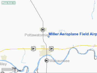
Miller Aeroplane Field Airport |
|
Location &
QuickFacts
|
FAA
Information Effective: |
2008-09-25 |
|
Airport
Identifier: |
83KS |
|
Airport
Status: |
Operational |
|
Longitude/Latitude: |
096-17-58.9800W/39-14-06.9700N
-96.299717/39.235269 (Estimated) |
|
Elevation: |
1020 ft / 310.90 m (Estimated) |
|
Land: |
0 acres |
|
From
nearest city: |
2 nautical miles N of Wamego, KS |
|
Location: |
Pottawatomie County, KS |
|
Magnetic Variation: |
05E (2000) |
Owner & Manager
|
Ownership: |
Privately owned |
|
Owner: |
John J. Miller |
|
Address: |
17950, Military Camp Road
Wamego, KS 66547 |
|
Phone
number: |
785-456-9470 |
|
Manager: |
John J. Miller |
|
Address: |
17950 Military Camp Road
Wamego, KS 66547 |
|
Phone number: |
785-456-9470 |
Airport Operations and Facilities
|
Airport
Use: |
Private |
|
Segmented Circle: |
No |
|
Control
Tower: |
No |
|
Sectional chart: |
Kansas City |
|
Region: |
ACE - Central |
|
Boundary
ARTCC: |
ZKC - Kansas City |
|
Tie-in
FSS: |
ICT - Wichita |
|
FSS Toll
Free: |
1-800-WX-BRIEF |
|
Runway Information
Runway 18/36
|
Dimension: |
2600 x 40 ft / 792.5 x 12.2 m |
|
Surface: |
TURF, Good Condition |
|
|
Runway 18
|
Runway 36
|
|
Traffic
Pattern: |
Right |
Left |
|
Radio Navigation Aids
|
ID |
Type |
Name |
Ch |
Freq |
Var |
Dist |
|
MQD |
NDB |
Mc Dowell Creek |
|
391.00 |
06E |
16.9 nm |
|
CVY |
NDB |
Cavalry |
|
314.00 |
06E |
26.3 nm |
|
TO |
NDB |
Biloy |
|
521.00 |
05E |
29.4 nm |
|
MYZ |
NDB |
Marysville |
|
341.00 |
06E |
40.2 nm |
|
HRU |
NDB |
Herington |
|
407.00 |
06E |
40.4 nm |
|
CYW |
NDB |
Clay Center |
|
362.00 |
07E |
41.0 nm |
|
DBX |
NDB |
Morrison |
|
212.00 |
06E |
46.8 nm |
|
FOE |
TACAN |
Forbes |
053X |
|
05E |
34.5 nm |
|
FRI |
VOR |
Fort Riley |
|
109.40 |
06E |
30.6 nm |
|
MHK |
VOR/DME |
Manhattan |
039X |
110.20 |
06E |
18.0 nm |
|
TOP |
VORTAC |
Topeka |
125X |
117.80 |
05E |
35.5 nm |
|
FOE |
VOT |
Forbes |
|
111.00 |
|
34.1 nm |
Remarks
-
PRVDD CLEAR APCH
TO EACH RY MIN 20:1 GLIDE RATIO, CLEAR TRANSITIONAL 7:1 SLOPE.
Based Aircraft
|
Aircraft based
on field: |
1 |
|
Single Engine
Airplanes: |
1 |
Miller Aeroplane Field Airport
Address:
Pottawatomie County, KS
Tel:
785-456-9470
Images
and information placed above are from
http://www.airport-data.com/airport/83KS/
We
thank them for the data!
|
General Info |
| Country |
United
States |
| State |
KANSAS
|
| FAA ID |
83KS
|
| Latitude |
39-14-06.970N |
|
Longitude |
096-17-58.980W |
|
Elevation |
1020
feet |
| Near
City |
WAMEGO
|
We don't guarantee the information is fresh and accurate. The data may
be wrong or outdated.
For more up-to-date information please refer to other sources.
|
|


