|
 |
|
||||
|
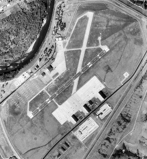
Marshall Army Airfield (MAAF) (IATA: FRI, ICAO: KFRI) is a military airfield located on Fort Riley, Kansas. It was opened in 1921. The primary mission for MAAF is to provide fully integrated fixed base helicopter operations for the Combat Aviation Brigade. Airfield operations and services include Base Flight Operations, Control Tower, and Ground Approach Control Facility, USAF weather, Airport Safety, Air Space Management, Flight Simulator, Rapid Refuel Facility, and Crash/Fire/Rescue station. The airfield has an FAA approved instrument approach. MAAF is the home of the 1st Infantry Division's Combat Aviation Brigade; The Combat Aviation Brigade currently has approximately 2,200 Soldiers assigned. The brigade currently has Black Hawks, Apaches and Chinooks at Fort Riley â the number fluctuates as aircraft go through maintenance and reset rotations. The unit is expecting nearly 120 aircraft total, including Kiowas. Co. A, 158th Aviation Regiment (AVIM); and numerous other military and civilian organizations. The airfield also provides CH-47, UH-60 and AH-64 Synthetic Flight Training Systems for all Fort Riley aviation units and specific National Guard. HistoryOriginsEarly claims exist for the Fort Riley polo field to have been the site in 1912 of the first experiments in directing artillery fire from an airplane, with stovepipes for bombsites. H. H. Arnold, a future Commanding General of the United States Army Air Forces and General of the Air Force, was among the participants. In 1921, Colonel Fred Herman selected the Smoky Hill Flats across the Kansas River as the location for a new airfield. The Fort Riley Flying Field opened in August of that year, and was home to the 16th Observation Squadron. The airfield was planned as a refueling point for cross-country flights and was equipped with hangars, underground fuel storage tanks, and lights for night operations. When the facilities were completed in 1923, the airfield was named Marshall Field after Brigadier General Francis C. Marshall, the Assistant Chief of Cavalry, who had died in a plane crash the year before. Marshall Field remained a quiet place for most of the 1920s and 1930s, with a mission of observation and photography during tactical exercises at Fort Riley, and performing aerial demonstrations. Aircraft from Marshall Field were also supplied by the 16th Observation Squadron to other 7th Corps installations. Beginning in March 1926 Marshall Field's fleet was mostly four or five De Havilland observation planes (DH-4s) and eight or ten Curtiss Jennies â all dating from World War I (WWI). World War IIAt the beginning of World War II, Marshall Field had two hangars and three unpaved landing strips; the longest was 3,700 feet. In order to handle the larger, heavier planes coming into use, the runways were paved and lengthened. In all, two 4,500 feet long, 150 feet wide concrete runways, six taxiways, and 5,400 square yards of parking apron were created to support the wartime aviation needs. The 1st Observation Squadron was shipped to the Canal Zone in late 1941, and the 6th Observation Squadron (Special), activated at Fort Sill in February 1942, moved to Marshall Field that April. The unit was re-designated the 6th Reconnaissance Squadron (Special) in June and again as the 2nd Composite Squadron (Special) in October. By this time the original 1942 complement of 15 liaison planes had been supplemented with 15 P-39s and five B-25s. Missions had also expanded from an observation and photography focus to include tactical air missions such as air-ground support demonstrations and simulated strafing, bombing, and chemical warfare missions. Cold WarEarly Cold War Development of Marshall Field Post-war reductions in force and equipment impacted Marshall Field, and by late 1946 only the 163rd Liaison Squadron manned the air field. They conducted visual reconnaissance in support of the Ground General School. The first assignment of helicopters at Fort Riley occurred in 1947 with the acquisition of six by the 163rd. For approximately two years, until 1 June 1950, the Air Force operated the facility as Marshall Air Force Base. During this time, the field provided an Instrument Training Center offering a refresher course for all Tenth Air Force pilots outside the 56th Fighter Wing. Thanks to conflict-driven innovations in flight and cargo hauling operations, helicopters assumed a much larger peacetime Army role after the Korean War. Fort Riley was an early beneficiary of the helicopter's increased importance in post-Korea U.S. Army air missions, becoming home to the 5th Army's first helicopter training facility. Air Force operations at Marshall ended in late 1953, and on 19 November 1953, the first three Sikorsky H-19-D helicopters purchased by the Army arrived fresh from the factory to be used in training at Marshall Field. The 98th Transportation Army Aircraft Repair Detachment at Fort Riley was the only unit of its type in the Fifth Army area in 1954, and serviced all of the planes for the region. Working largely in the hangars at Marshall Field, the unit worked primarily on engines, instruments, and rigging. Around the same time, the 328th Helicopter Transportation Company transferred overseas, and the 21st Transportation Helicopter Battalion was activated at Marshall Field. The first unit of its kind in the Army, the battalion's mission was to "activate, supply, and supervise training of helicopter companies to prepare them as combat ready units for assignment overseas or with units in the United States." Advancements in military aircraft and airborne combat tactics kept the units at Marshall Field supplied with new machines, new units, and new training courses. By March 1955, the 71st Helicopter Transportation Battalion was training pilots in the operation of twin rotor helicopters, first the Piesecki H-25-A, then the larger H-21-C. The emphasis on helicopters did not result in neglect for fixed-wing aircraft at Fort Riley. The post was selected as the home of the 14th Army Aviation Company in June 1955. Activated as a Fixed-Wing Tactical Transport unit, it was the first of its type and flew the 14-seat DeHaviland U-1 Otter. Big news arrived on 21 July 1955, with receipt of a directive to activate the first Army Aviation Unit Training Command (AAUTC) at Fort Riley. The creation of the AAUTC was the result of the rapid expansion in Army aviation units in the mid-1950s. Seeking to utilize existing resources, the Department of the Army established two AAUTCs in 1955: one at Fort Riley and one at Fort Sill. The 71st Transportation Battalion was assigned the training mission on 24 January, and the AAUTC became operational on 18 February, making it the first of its kind in the Army. The above content comes from Wikipedia and is published under free licenses – click here to read more.
Runway Information Runway 04/22
Runway 18/36
Helipad H1
Radio Navigation Aids
Remarks
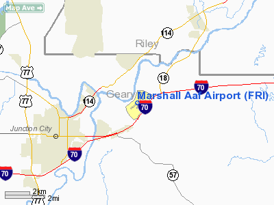
Marshall Aaf Airport Address: Riley County, KS Tel: 785-239-2078 Images
and information placed above are from We thank them for the data!
We don't guarantee the information is fresh and accurate. The data may
be wrong or outdated.
|
|||||||||||||||||||||||||||||||||||||||||||||||||||||||||||||||||||||||||||||||||||||||||||||||||||||||||||||||||||||||||||||||||||||||||||||||||||||||||||||||||||||||||||||||||||||||||||||||||||||||||||||||||||||||||||||||||||||||||||||||||||||||||||||||||||||||||||||||||||||||||||||||||||||||||

 |
|
Copyright 2004-2026 © by Airports-Worldwide.com, Vyshenskoho st. 36, Lviv 79010, Ukraine Legal Disclaimer |