 |
|
| Mankato Airport |
| IATA: none â ICAO: KTKO â FAA LID: TKO |
| Summary |
| Airport type |
Public |
| Owner |
City of Mankato |
| Serves |
Mankato, Kansas |
| Elevation AMSL |
1,859 ft / 567 m |
| Coordinates |
39°48â²17â³N 098°13â²14â³W / 39.80472°N 98.22056°W / 39.80472; -98.22056 |
| Runways |
| Direction |
Length |
Surface |
| ft |
m |
| 17/35 |
3,540 |
1,079 |
Asphalt |
| 9/27 |
2,505 |
764 |
Turf |
| Statistics (2009) |
| Aircraft operations |
5,400 |
| Source: Federal Aviation Administration |
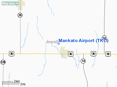
Mankato Airport (ICAO: KTKO, FAA LID: TKO) is a city-owned public-use airport located one nautical mile (1.85 km) northwest of the central business district of Mankato, a city in Jewell County, Kansas, United States.
Although most U.S. airports use the same three-letter location identifier for the FAA and IATA, this airport is assigned TKO by the FAA but has no designation from the IATA.
Facilities and aircraft
Mankato Airport covers an area of 203 acres (82 ha) at an elevation of 1,859 feet (567 m) above mean sea level. It has two runways: 17/35 is 3,540 by 50 feet (1,079 x 15 m) with an asphalt pavement and 9/27 is 2,505 by 100 feet (764 x 30 m) with a turf surface. For the 12-month period ending February 20, 2009, the airport had 5,400 general aviation aircraft operations, an average of 14 per day.
The above content comes from Wikipedia and is published under free licenses – click here to read more.
|
Location &
QuickFacts
|
FAA
Information Effective: |
2008-09-25 |
|
Airport
Identifier: |
TKO |
|
Airport
Status: |
Operational |
|
Longitude/Latitude: |
098-13-16.1830W/39-48-10.0440N
-98.221162/39.802790 (Estimated) |
|
Elevation: |
1859 ft / 566.62 m (Estimated) |
|
Land: |
203 acres |
|
From
nearest city: |
1 nautical miles NW of Mankato, KS |
|
Location: |
Jewell County, KS |
|
Magnetic Variation: |
07E (1985) |
Owner & Manager
|
Ownership: |
Publicly owned |
|
Owner: |
City Of Mankato |
|
Address: |
202 E. Jefferson
Mankato, KS 66956 |
|
Phone number: |
785-378-3141 |
|
Manager: |
Phil Walton |
|
Address: |
Box 323
Mankato, KS 66956 |
|
Phone number: |
785-378-3942 |
Airport
Operations and Facilities
|
Airport
Use: |
Open to public |
|
Wind
indicator: |
Yes |
|
Segmented Circle: |
No |
|
Control
Tower: |
No |
|
Lighting
Schedule: |
DUSK-DAWN |
|
Landing
fee charge: |
No |
|
Sectional chart: |
Wichita |
|
Region: |
ACE - Central |
|
Boundary
ARTCC: |
ZMP - Minneapolis |
|
Tie-in
FSS: |
ICT - Wichita |
|
FSS on
Airport: |
No |
|
FSS Toll
Free: |
1-800-WX-BRIEF |
|
NOTAMs
Facility: |
ICT (NOTAM-d service avaliable) |
Airport Communications
Airport Services
|
Airframe
Repair: |
NONE |
|
Power
Plant Repair: |
NONE |
|
Bottled
Oxygen: |
NONE |
|
Bulk
Oxygen: |
NONE |
|
Runway Information
Runway 09/27
|
Dimension: |
2505 x 100 ft / 763.5 x 30.5 m |
|
Surface: |
TURF, Good Condition
AT THE INTERSECTION OF 09/27 & 17/35 A SLIGHT CHANGE IN ELEVATION MAY CAUSE
A ROUGH CROSSING. |
|
|
Runway 09
|
Runway 27
|
|
Traffic
Pattern: |
Left |
Left |
|
Markings: |
Nonstandard,
09/27 APCH ENDS MARKED WITH WHITE PAINTED TIRES. |
Nonstandard, |
|
Obstruction: |
19 ft trees, 100 ft right of centerline |
15 ft road, 120.0 ft from runway, 8:1 slope to clear |
|
Runway 17/35
|
Dimension: |
3540 x 50 ft / 1079.0 x 15.2 m |
|
Surface: |
ASPH, Good Condition
AT THE INTERSECTION OF 09/27 & 17/35 A SLIGHT CHANGE IN ELEVATION MAY CAUSE
A ROUGH CROSSING. |
|
Edge Lights: |
Low |
|
|
Runway 17
|
Runway 35
|
|
Traffic
Pattern: |
Left |
Left |
|
Markings: |
Numbers only, Good Condition |
Numbers only, Good Condition |
|
Obstruction: |
4 ft fence, 200.0 ft from runway |
, 50:1 slope to clear
SEVERAL SMALL TREES ARE 60 TO 75 FEET LT AND RT OF CENTERLINE AND
APPROXIMATELY 65 FEET FROM THE APPROACH END OF RWY 35. |
|
Radio Navigation Aids
|
ID |
Type |
Name |
Ch |
Freq |
Var |
Dist |
|
RPB |
NDB |
Republican |
|
414.00 |
07E |
26.0 nm |
|
CNK |
NDB |
Concordia |
|
335.00 |
06E |
30.3 nm |
|
HJH |
NDB |
Hebron |
|
323.00 |
06E |
35.9 nm |
|
PHG |
NDB |
Phillipsburg |
|
368.00 |
08E |
49.7 nm |
|
HSI |
VOR/DME |
Hastings |
025X |
108.80 |
07E |
49.1 nm |
|
TKO |
VORTAC |
Mankato |
035X |
109.80 |
10E |
1.8 nm |
Remarks
-
LGTD/MKD TWR 2 MI
NE OF ARPT 300' AGL; ALSO A MKD/LGTD 300+ AGL TWR APRX 1.5 MI SE OF ARPT.
-
TELEPHONE AVBL 24
HRS.(LCL CALLS ONLY}
-
PRVDD RWY APCHS
MAINT FOR MIN 20:1 GLIDE SLOPE & TRSNL SFC MAINT FOR 7:1 SLOPE.
Based Aircraft
|
Aircraft based
on field: |
2 |
|
Single Engine
Airplanes: |
2 |
Operational Statistics
Time Period: 2007-05-22 - 2008-05-20
|
Aircraft
Operations: |
104/Week |
|
General
Aviation Local: |
44.4% |
|
General
Aviation Itinerant: |
55.6% |
Mankato Airport
Address:
Jewell County, KS
Tel:
785-378-3141, 785-378-3942
Images
and information placed above are from
http://www.airport-data.com/airport/TKO/
We
thank them for the data!
|
General Info |
| Country |
United
States |
| State |
KANSAS
|
| FAA ID |
TKO
|
| Latitude |
39-48-10.044N |
|
Longitude |
098-13-16.183W |
|
Elevation |
1859
feet |
| Near
City |
MANKATO
|
We don't guarantee the information is fresh and accurate. The data may
be wrong or outdated.
For more up-to-date information please refer to other sources.
|
|


