|
|
Lloyd Stearman Field Airport |
Benton Airpark
Lloyd Stearman Field |
| IATA: 1K1 â ICAO: 1K1 â FAA LID: 1K1 |
| Summary |
| Airport type |
Public |
| Operator |
Benton Airpark, Inc. |
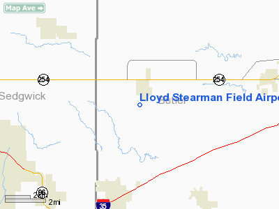
| Location |
Benton, Kansas |
| Elevation AMSL |
1,364 ft / 415.7 m |
| Coordinates |
37°46â²40â³N 97°06â²49â³W / 37.77778°N 97.11361°W / 37.77778; -97.11361Coordinates: 37°46â²40â³N 97°06â²49â³W / 37.77778°N 97.11361°W / 37.77778; -97.11361 |
| Runways |
| Direction |
Length |
Surface |
| ft |
m |
| 17/35 |
5,100 |
1,554 |
Asphalt |
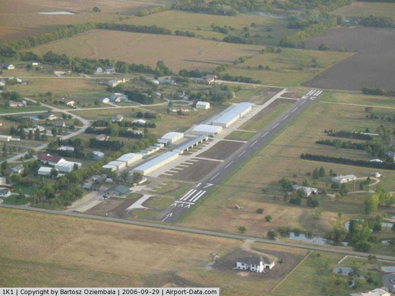
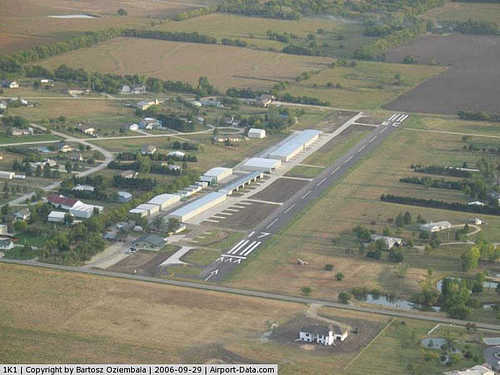
Lloyd Stearman Field (FAA LID: 1K1), also known as Benton Airpark, is a public airport located one mile (1.6 km) southwest of the central business district (CBD) of Benton, in Butler County, Kansas, USA. The airport covers 30 acres and has one runway. It was named in honor of aviation pioneer Lloyd Stearman and seven Stearman World War II era training biplanes are based there.
Services
In early 2010, a restaurant, Stearman Field Bar & Grill, opened on the airport property. The restaurant serves typical cafe food, such as hamburgers and steaks, as well as a full bar. Other services include flight training and 24 hour credit card fueling available.
The above content comes from Wikipedia and is published under free licenses – click here to read more.
|
 |
(Click on the photo to enlarge) |
|
Location &
QuickFacts
|
FAA
Information Effective: |
2008-09-25 |
|
Airport
Identifier: |
1K1 |
|
Airport
Status: |
Operational |
|
Longitude/Latitude: |
097-06-48.6410W/37-46-40.3530N
-97.113511/37.777876 (Estimated) |
|
Elevation: |
1364 ft / 415.75 m (Surveyed) |
|
Land: |
30 acres |
|
From
nearest city: |
1 nautical miles SW of Benton, KS |
|
Location: |
Butler County, KS |
|
Magnetic Variation: |
04E (2010) |
Owner & Manager
|
Ownership: |
Privately owned |
|
Owner: |
Benton Airpark Inc.
RESIDENTIAL AIRPARK OWNER LIVES ON ARPT. |
|
Address: |
14789 Southwest 30th. Street
Benton, KS 67017 |
|
Phone
number: |
316-778-1035 |
|
Manager: |
Debbie Largen |
|
Address: |
14789 Southwest 30th. Street
Benton, KS 67017 |
|
Phone number: |
316-778-1542 |
Airport Operations and Facilities
|
Airport
Use: |
Open to public |
|
Wind
indicator: |
Yes |
|
Segmented Circle: |
No |
|
Control
Tower: |
No |
|
Lighting
Schedule: |
DUSK-DAWN |
|
Beacon
Color: |
Clear-Green (lighted land airport) |
|
Landing
fee charge: |
No |
|
Sectional chart: |
Wichita |
|
Region: |
ACE - Central |
|
Boundary
ARTCC: |
ZKC - Kansas City |
|
Tie-in
FSS: |
ICT - Wichita |
|
FSS on
Airport: |
No |
|
FSS Toll
Free: |
1-800-WX-BRIEF |
|
NOTAMs
Facility: |
ICT (NOTAM-d service avaliable) |
Airport
Communications
|
CTAF: |
123.075 |
|
Unicom: |
123.075
FOR CLNC DLVY CTC ICT APCH ON FREQ 125.0 OR CALL 316-946-0064. |
Airport Services
|
Fuel
available: |
100LL
24 HR CREDIT CARD |
|
Airframe
Repair: |
MAJOR |
|
Power
Plant Repair: |
MAJOR |
|
Bottled
Oxygen: |
NONE |
|
Bulk
Oxygen: |
NONE |
|
Runway Information
Runway 17/35
|
Dimension: |
2613 x 60 ft / 796.4 x 18.3 m |
|
Surface: |
ASPH, Good Condition |
|
Edge Lights: |
Low |
|
|
Runway 17
|
Runway 35
|
|
Longitude: |
097-06-49.7600W |
097-06-47.4650W |
|
Latitude: |
37-46-53.2300N |
37-46-27.4670N |
|
Elevation: |
1364.00 ft |
1347.00 ft |
|
Alignment: |
127 |
127 |
|
Traffic
Pattern: |
Right |
Left |
|
Markings: |
Basic, Good Condition |
Basic, Good Condition |
|
Crossing
Height: |
35.00 ft |
31.00 ft |
|
Displaced
threshold: |
250.00 ft |
0.00 ft |
|
VASI: |
tri-color on left side |
tri-color on left side |
|
Visual
Glide Angle: |
4.00° |
4.00° |
|
Obstruction: |
, 50:1 slope to clear
APCH RATIO 18:1 OVER +15 FT ROAD 280 FT M DSPLCD THLD.
ROAD 15' 30' FROM RWY END. |
50 ft trees, 2200.0 ft from runway, 40:1 slope to clear |
|
Radio Navigation Aids
|
ID |
Type |
Name |
Ch |
Freq |
Var |
Dist |
|
EQA |
NDB |
El Dorado |
|
383.00 |
05E |
14.1 nm |
|
EWK |
NDB |
Newton |
|
281.00 |
06E |
18.8 nm |
|
IC |
NDB |
Piche |
|
332.00 |
07E |
20.2 nm |
|
EGT |
NDB |
Wellington |
|
414.00 |
07E |
30.3 nm |
|
MPR |
NDB |
Mc Pherson |
|
227.00 |
06E |
43.7 nm |
|
IAB |
TACAN |
Mc Connell |
112X |
|
07E |
11.9 nm |
|
HUT |
VOR/DME |
Hutchinson |
115X |
116.80 |
09E |
41.1 nm |
|
ICT |
VORTAC |
Wichita |
085X |
113.80 |
07E |
22.4 nm |
|
ICT |
VOT |
Wichita |
|
114.00 |
|
17.4 nm |
Remarks
-
TURF OPS WEST OF
RY.
-
FOR ASSISTANCE
AFT HRS CALL 316-648-0132 OR NRS POSTED AT FBO.
Based Aircraft
|
Aircraft based
on field: |
84 |
|
Single Engine
Airplanes: |
80 |
|
Multi Engine
Airplanes: |
2 |
|
Helicopters: |
2 |
Operational Statistics
Time Period: 2007-06-05 - 2008-06-03
|
Aircraft
Operations: |
202/Week |
|
General
Aviation Local: |
95.2% |
|
General
Aviation Itinerant: |
4.8% |
Lloyd Stearman Field Airport
Address:
Butler County, KS
Tel:
316-778-1035,
316-778-1542
Images
and information placed above are from
http://www.airport-data.com/airport/1K1/
We
thank them for the data!
We don't guarantee the information is fresh and accurate. The data may
be wrong or outdated.
For more up-to-date information please refer to other sources.
|
|