 |
|
Liberal Mid-america Regional Airport |
| Liberal Mid-America Regional Airport |
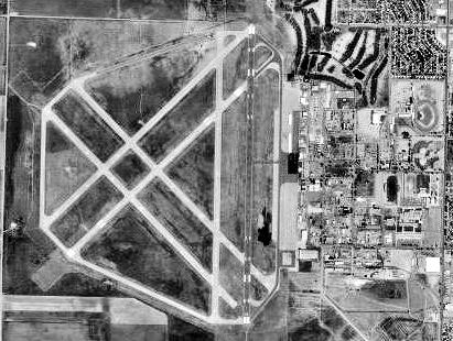 |
| 1995 USGS Photo |
| IATA: LBL â ICAO: KLBL â FAA LID: LBL |
| Summary |
| Airport type |
Public |
| Owner |
City of Liberal |
| Serves |
Liberal, Kansas |
| Elevation AMSL |
2,885 ft / 879 m |
| Runways |
| Direction |
Length |
Surface |
| ft |
m |
| 4/22 |
5,721 |
1,744 |
Concrete |
| 17/35 |
7,105 |
2,166 |
Concrete |
| Statistics (2006) |
| Aircraft operations |
43,550 |
| Based aircraft |
63 |
| Source: FAA and airport web page |
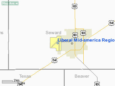
Coordinates: 37°02â²39â³N 100°57â²36â³W / 37.04417°N 100.96°W / 37.04417; -100.96 Liberal Mid-America Regional Airport (IATA: LBL, ICAO: KLBL, FAA LID: LBL), formerly known as Liberal Municipal Airport, is a city-owned public-use airport located two miles (3 km) west of the central business district of Liberal, a city in Seward County, Kansas, United States. It is mostly used for general aviation, but is also served by one commercial airline. Service is subsidized by the Essential Air Service program.
The airport also hosts the Mid-America Air Museum. History
During World War II, the facility was known as Liberal Army Airfield and was used as a United States Army Air Forces Second Air Force B-24 Liberator training base from 1943 to 1945. Newly minted multi-engine graduates were shipped to Liberal to transition to the Liberator, then sent to 1st Phase bases to be joined up with a crew for combat training.
Before April 1944, Liberal was home to a Twin Engine Flying Training Group with four squadrons (60, 63, 1029, 1030), the 527th Base Hq & Air Base Sq, 324th Sub Depot, 444th (later 744th) AAF Band, and 396th Aviation Sq.
Afterwards, these units were merged into the 2425th AAF Base Unit (Pilot School, Specialized, Four Engine)
Facilities and aircraft
Liberal Mid-America Regional Airport covers an area of 2,005 acres (811 ha) which contains two concrete paved runways: 4/22 measuring 5,721 x 150 ft. (1,744 x 46 m) and 17/35 measuring 7,105 x 100 ft. (2,166 x 30 m). It also has several other runways that are now inoperative.
For the 12-month period ending December 31, 2006, the airport had 43,550 aircraft operations, an average of 119 per day: 90% general aviation, 7% scheduled commercial, 2% air taxi and 1% military. There are 63 aircraft based at this airport: 68% single-engine, 21% multi-engine, 10% jet and 2% helicopter.
Airlines and destinations
| Airlines |
Destinations |
| Great Lakes Airlines |
Denver, Garden City |
The above content comes from Wikipedia and is published under free licenses – click here to read more.
|
Location &
QuickFacts
|
FAA
Information Effective: |
2008-09-25 |
|
Airport
Identifier: |
LBL |
|
Airport
Status: |
Operational |
|
Longitude/Latitude: |
100-57-35.5000W/37-02-39.2000N
-100.959861/37.044222 (Estimated) |
|
Elevation: |
2885 ft / 879.35 m (Surveyed) |
|
Land: |
2005 acres |
|
From
nearest city: |
2 nautical miles W of Liberal, KS |
|
Location: |
Seward County, KS |
|
Magnetic Variation: |
10E (1980) |
Owner & Manager
|
Ownership: |
Publicly owned |
|
Owner: |
City Of Liberal |
|
Address: |
Po Box 2199
Liberal, KS 67905-2199 |
|
Phone number: |
620-626-0101 |
|
Manager: |
Ms. Debra Giskie |
|
Address: |
Po Box 2199
Liberal, KS 67905-2199 |
|
Phone number: |
620-626-0157 |
Airport
Operations and Facilities
|
Airport
Use: |
Open to public |
|
Wind
indicator: |
Yes |
|
Segmented Circle: |
Yes |
|
Control
Tower: |
No |
|
Lighting
Schedule: |
DUSK-DAWN
ACTVT MIRL RY 04/22 & HIRL RY 17/35; MALSR RY 35; VASI RYS 17 & 35; &
PAPI RYS 04 & 22; REIL RYS 04; 17 & 22 - CTAF. |
|
Beacon
Color: |
Clear-Green (lighted land airport) |
|
Landing
fee charge: |
No |
|
Sectional chart: |
Wichita |
|
Region: |
ACE - Central |
|
Boundary
ARTCC: |
ZKC - Kansas City |
|
Tie-in
FSS: |
ICT - Wichita |
|
FSS on
Airport: |
No |
|
FSS Toll
Free: |
1-800-WX-BRIEF |
|
NOTAMs
Facility: |
LBL (NOTAM-d service avaliable) |
|
Certification type/date: |
II A S 12/198
24 HR PPR FOR UNSKED ACR OPNS WITH MORE THAN 30 PSGR SEATS CALL AMGR
(620) 626-0157 OR (620) 626-0150. |
|
Federal Agreements: |
NGPY |
Airport Communications
|
CTAF: |
122.800 |
|
Unicom: |
122.800 |
Airport Services
|
Fuel
available: |
100LLA |
|
Airframe
Repair: |
MAJOR |
|
Power
Plant Repair: |
MAJOR |
|
Bottled
Oxygen: |
NONE |
|
Bulk
Oxygen: |
LOW |
|
Runway Information
Runway 04/22
|
Dimension: |
5721 x 150 ft / 1743.8 x 45.7 m |
|
Surface: |
CONC, Fair Condition |
|
Weight Limit: |
Single wheel: 36000 lbs.
Dual wheel: 58000 lbs. |
|
Edge Lights: |
Medium |
|
|
Runway 04
|
Runway 22
|
|
Longitude: |
100-58-15.7665W |
100-57-25.9752W |
|
Latitude: |
37-02-19.2255N |
37-02-59.2906N |
|
Elevation: |
2884.00 ft |
2876.00 ft |
|
Alignment: |
45 |
127 |
|
Traffic
Pattern: |
Left |
Left |
|
Markings: |
Non-precision instrument, Good Condition |
Non-precision instrument, Good Condition |
|
Crossing
Height: |
39.00 ft |
25.00 ft |
|
VASI: |
4-light PAPI on left side |
4-light PAPI on left side |
|
Visual
Glide Angle: |
3.00° |
3.00° |
|
Runway End
Identifier: |
Yes |
Yes |
|
Runway 17/35
|
Dimension: |
7105 x 100 ft / 2165.6 x 30.5 m |
|
Surface: |
CONC, |
|
Surface
Treatment: |
Saw-cut or plastic Grooved |
|
Weight Limit: |
Single wheel: 80000 lbs.
Dual wheel: 100000 lbs. |
|
Edge Lights: |
High |
|
|
Runway 17
|
Runway 35
|
|
Longitude: |
100-57-23.1752W |
100-57-23.0080W |
|
Latitude: |
37-03-14.1976N |
37-02-03.9571N |
|
Elevation: |
2876.00 ft |
2875.00 ft |
|
Alignment: |
127 |
127 |
|
ILS Type: |
|
ILS |
|
Traffic
Pattern: |
Left |
Left |
|
Markings: |
Precision instrument, Good Condition |
Precision instrument, Good Condition |
|
Crossing
Height: |
32.00 ft |
47.00 ft |
|
VASI: |
4-box on left side |
4-box on left side |
|
Visual
Glide Angle: |
3.00° |
3.00° |
|
Approach
lights: |
|
MALSR |
|
Runway End
Identifier: |
Yes |
|
|
Radio Navigation Aids
|
ID |
Type |
Name |
Ch |
Freq |
Var |
Dist |
|
HQG |
NDB |
Hugoton |
|
365.00 |
09E |
21.1 nm |
|
MEJ |
NDB |
Meade |
|
389.00 |
09E |
32.2 nm |
|
GUY |
NDB |
Guymon |
|
275.00 |
09E |
33.2 nm |
|
ULS |
NDB |
Ulysses |
|
395.00 |
09E |
38.5 nm |
|
PYX |
NDB |
Perryton |
|
266.00 |
09E |
39.3 nm |
|
EHA |
NDB |
Elkhart |
|
377.00 |
10E |
44.5 nm |
|
GC |
NDB |
Pieve |
|
347.00 |
09E |
48.5 nm |
|
LBL |
VORTAC |
Liberal |
070X |
112.30 |
11E |
0.5 nm |
Based Aircraft
|
Aircraft based
on field: |
57 |
|
Single Engine
Airplanes: |
40 |
|
Multi Engine
Airplanes: |
13 |
|
Jet Engine
Airplanes: |
3 |
|
Helicopters: |
1 |
Operational Statistics
Time Period: 2007-01-01 - 2007-12-31
|
Aircraft
Operations: |
117/Day |
|
Commerical: |
4.7% |
|
Air Taxi: |
2.4% |
|
General
Aviation Local: |
40.0% |
|
General
Aviation Itinerant: |
51.8% |
|
Military: |
1.2% |
Liberal Mid-america Regional Airport
Address:
Seward County, KS
Tel:
620-626-0101, 620-626-0157
Images
and information placed above are from
http://www.airport-data.com/airport/LBL/
We
thank them for the data!
|
General Info |
| Country |
United
States |
| State |
KANSAS
|
| FAA ID |
LBL
|
| Latitude |
37-02-39.154N |
|
Longitude |
100-57-35.500W |
|
Elevation |
2883
feet |
| Near
City |
LIBERAL
|
We don't guarantee the information is fresh and accurate. The data may
be wrong or outdated.
For more up-to-date information please refer to other sources.
|
|


