 |
|
Lawrence Municipal Airport |
| Lawrence Municipal Airport |
| IATA: LWC â ICAO: KLWC â FAA LID: LWC |
| Summary |
| Airport type |
Public |
| Owner |
City of Lawrence |
| Serves |
Lawrence, Kansas |
| Elevation AMSL |
833 ft / 254 m |
| Coordinates |
39°00â²40â³N 095°12â²59â³W / 39.01111°N 95.21639°W / 39.01111; -95.21639 |
| Runways |
| Direction |
Length |
Surface |
| ft |
m |
| 15/33 |
5,700 |
1,737 |
Asphalt |
| 1/19 |
3,901 |
1,189 |
Concrete |
| Statistics (2008) |
| Aircraft operations |
32,700 |
| Based aircraft |
56 |
| Source: Federal Aviation Administration |
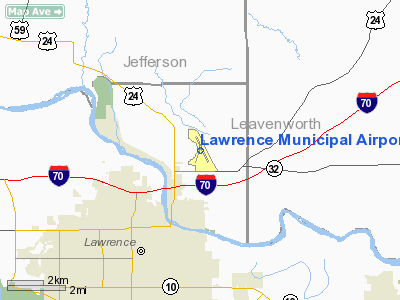
Lawrence Municipal Airport (IATA: LWC, ICAO: KLWC, FAA LID: LWC) is a city-owned public-use airport located three nautical miles (6 km) north of the central business district of Lawrence, a city in Douglas County, Kansas, United States.
Facilities and aircraft
Lawrence Municipal Airport covers an area of 486 acres (197 ha) at an elevation of 833 feet (254 m) above mean sea level. It has two runways: 15/33 is 5,700 by 100 feet (1,737 x 30 m) with an asphalt surface and 1/19 is 3,901 by 75 feet (1,189 x 23 m) with a concrete surface.
For the 12-month period ending September 30, 2008, the airport had 32,700 aircraft operations, an average of 89 per day: 93% general aviation, 6% air taxi and <1% military. At that time there were 56 aircraft based at this airport: 91% single-engine, 5% multi-engine, 2% jet and 2% helicopter.
The above content comes from Wikipedia and is published under free licenses – click here to read more.
|
Location &
QuickFacts
|
FAA
Information Effective: |
2008-09-25 |
|
Airport
Identifier: |
LWC |
|
Airport
Status: |
Operational |
|
Longitude/Latitude: |
095-12-59.6770W/39-00-40.1480N
-95.216577/39.011152 (Estimated) |
|
Elevation: |
832 ft / 253.59 m (Surveyed) |
|
Land: |
486 acres |
|
From
nearest city: |
3 nautical miles N of Lawrence, KS |
|
Location: |
Douglas County, KS |
|
Magnetic Variation: |
05E (1995) |
Owner & Manager
|
Ownership: |
Publicly owned |
|
Owner: |
City Of Lawrence |
|
Address: |
6 East 6th Street
Lawrence, KS 66044 |
|
Phone
number: |
785-832-3400 |
|
Manager: |
Debbie Van Saun |
|
Address: |
6 East 6th Street
Lawrence, KS 66044 |
|
Phone number: |
785-832-3402 |
Airport Operations and Facilities
|
Airport
Use: |
Open to public |
|
Wind
indicator: |
Yes |
|
Segmented Circle: |
Yes |
|
Control
Tower: |
No |
|
Lighting
Schedule: |
DUSK-DAWN
ACTVT MIRL RYS 01/19 & 15/33; PAPI RYS 01/19 & 15/33; REIL RYS 01 &
19; MALSR RY 33 - CTAF. |
|
Beacon
Color: |
Clear-Green (lighted land airport) |
|
Landing
fee charge: |
No |
|
Sectional chart: |
Kansas City |
|
Region: |
ACE - Central |
|
Boundary
ARTCC: |
ZKC - Kansas City |
|
Tie-in
FSS: |
ICT - Wichita |
|
FSS on
Airport: |
No |
|
FSS Toll
Free: |
1-800-WX-BRIEF |
|
NOTAMs
Facility: |
LWC (NOTAM-d service avaliable) |
|
Federal Agreements: |
NGY |
Airport Communications
|
CTAF: |
123.000 |
|
Unicom: |
123.000 |
Airport Services
|
Fuel
available: |
100LLA
FOR FUEL AFT HRS CALL 785-842-6332. |
|
Airframe
Repair: |
MAJOR |
|
Power
Plant Repair: |
MAJOR |
|
Bottled
Oxygen: |
HIGH |
|
Bulk
Oxygen: |
HIGH |
|
Runway Information
Runway 01/19
|
Dimension: |
3901 x 75 ft / 1189.0 x 22.9 m |
|
Surface: |
CONC, Good Condition |
|
Weight Limit: |
Single wheel: 12500 lbs.
Dual wheel: 15600 lbs. |
|
Edge Lights: |
Medium |
|
|
Runway 01
|
Runway 19
|
|
Longitude: |
095-13-11.8860W |
095-12-55.6490W |
|
Latitude: |
39-00-19.0170N |
39-00-55.4360N |
|
Elevation: |
832.00 ft |
830.00 ft |
|
Alignment: |
19 |
127 |
|
Traffic
Pattern: |
Left |
Left |
|
Markings: |
Non-precision instrument, Good Condition |
Non-precision instrument, Good Condition |
|
VASI: |
2-light PAPI on left side |
2-light PAPI on left side |
|
Runway End
Identifier: |
Yes |
Yes |
|
Obstruction: |
, 50:1 slope to clear |
70 ft tree, 2688.0 ft from runway, 47 ft right of
centerline, 35:1 slope to clear |
|
Runway 15/33
|
Dimension: |
5700 x 100 ft / 1737.4 x 30.5 m |
|
Surface: |
ASPH, Good Condition |
|
Weight Limit: |
Single wheel: 40000 lbs.
Dual wheel: 60000 lbs. |
|
Edge Lights: |
Medium |
|
|
Runway 15
|
Runway 33
|
|
Longitude: |
095-13-12.3240W |
095-12-40.0710W |
|
Latitude: |
39-01-07.1710N |
39-00-16.7660N |
|
Elevation: |
831.00 ft |
827.00 ft |
|
Alignment: |
127 |
127 |
|
ILS Type: |
|
ILS |
|
Traffic
Pattern: |
Left |
Left |
|
Markings: |
Precision instrument, Good Condition |
Precision instrument, Good Condition |
|
Crossing
Height: |
45.00 ft |
50.00 ft |
|
VASI: |
4-light PAPI on left side |
4-light PAPI on right side |
|
Visual
Glide Angle: |
3.00° |
3.00° |
|
Approach
lights: |
|
MALSR |
|
Obstruction: |
69 ft trees, 1908.0 ft from runway, 10 ft left of
centerline, 24:1 slope to clear |
, 50:1 slope to clear |
|
Radio Navigation Aids
|
ID |
Type |
Name |
Ch |
Freq |
Var |
Dist |
|
TO |
NDB |
Biloy |
|
521.00 |
05E |
22.9 nm |
|
DO |
NDB |
Dotte |
|
359.00 |
05E |
25.2 nm |
|
GQ |
NDB |
Norge |
|
517.00 |
05E |
26.4 nm |
|
GKB |
NDB |
Norge |
|
517.00 |
05E |
26.4 nm |
|
LXT |
NDB |
Lesumit |
|
263.00 |
04E |
39.6 nm |
|
GPH |
NDB |
Mosby |
|
284.00 |
03E |
46.9 nm |
|
UKL |
NDB |
Boyd |
|
245.00 |
05E |
48.9 nm |
|
FOE |
TACAN |
Forbes |
053X |
|
05E |
21.1 nm |
|
OJC |
VOR/DME |
Johnson County |
077X |
113.00 |
06E |
24.7 nm |
|
RIS |
VOR/DME |
Riverside |
051X |
111.40 |
05E |
29.7 nm |
|
TOP |
VORTAC |
Topeka |
125X |
117.80 |
05E |
17.3 nm |
|
MCI |
VORTAC |
Kansas City |
079Y |
113.25 |
05E |
27.8 nm |
|
FOE |
VOT |
Forbes |
|
111.00 |
|
21.3 nm |
|
MKC |
VOT |
Kansas City Downtown |
|
108.60 |
|
29.6 nm |
Based Aircraft
|
Aircraft based
on field: |
56 |
|
Single Engine
Airplanes: |
51 |
|
Multi Engine
Airplanes: |
3 |
|
Jet Engine
Airplanes: |
1 |
|
Helicopters: |
1 |
Operational Statistics
Time Period: 2006-07-01 - 2007-06-30
|
Aircraft
Operations: |
90/Day |
|
Air Taxi: |
6.4% |
|
General
Aviation Local: |
41.7% |
|
General
Aviation Itinerant: |
51.4% |
|
Military: |
0.5% |
Lawrence Municipal Airport
Address:
Douglas County, KS
Tel:
785-832-3400,
785-832-3402
Images
and information placed above are from
http://www.airport-data.com/airport/LWC/
We
thank them for the data!
|
General Info |
| Country |
United
States |
| State |
KANSAS
|
| FAA ID |
LWC
|
| Latitude |
39-00-40.148N |
|
Longitude |
095-12-59.677W |
|
Elevation |
832 feet
|
| Near
City |
LAWRENCE
|
We don't guarantee the information is fresh and accurate. The data may
be wrong or outdated.
For more up-to-date information please refer to other sources.
|
|


