|
|
Johnson County Executive Airport |
| Johnson County Executive Airport |
 |
| IATA: OJC â ICAO: KOJC â FAA LID: OJC |
| Summary |
| Airport type |
Public |
| Operator |
Johnson County Airport Commission |
| Location |
Olathe, Kansas |
| Elevation AMSL |
1,096 ft / 334.1 m |
| Coordinates |
38°50â²51â³N 94°44â²15â³W / 38.8475°N 94.7375°W / 38.8475; -94.7375Coordinates: 38°50â²51â³N 94°44â²15â³W / 38.8475°N 94.7375°W / 38.8475; -94.7375 |
| Runways |
| Direction |
Length |
Surface |
| ft |
m |
| 18/36 |
4,098 |
1,249 |
Concrete |
| Helipads |
| Number |
Length |
Surface |
| ft |
m |
| H1 |
100 |
30 |
Asphalt |
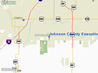
Johnson County Executive Airport (IATA: OJC, ICAO: KOJC, FAA LID: OJC) is a public airport located four miles (6 km) southeast of the central business district (CBD) of Olathe, a city in Johnson County, Kansas, USA. It is currently the second busiest airport in the state of Kansas. History
The airport was built as a Naval Auxiliary field for use in World War II. It was deeded to the city of Olathe in 1951, and to Johnson County in 1967. The airport has approximately 121,000 yearly operations; with over 225 aircraft based at the airport.
Facilities
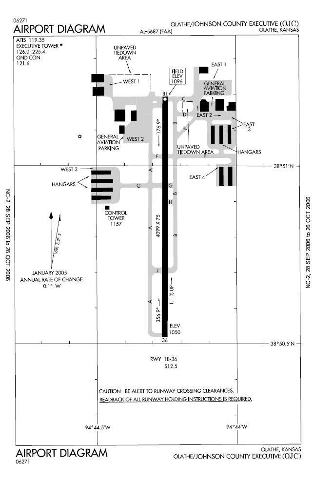
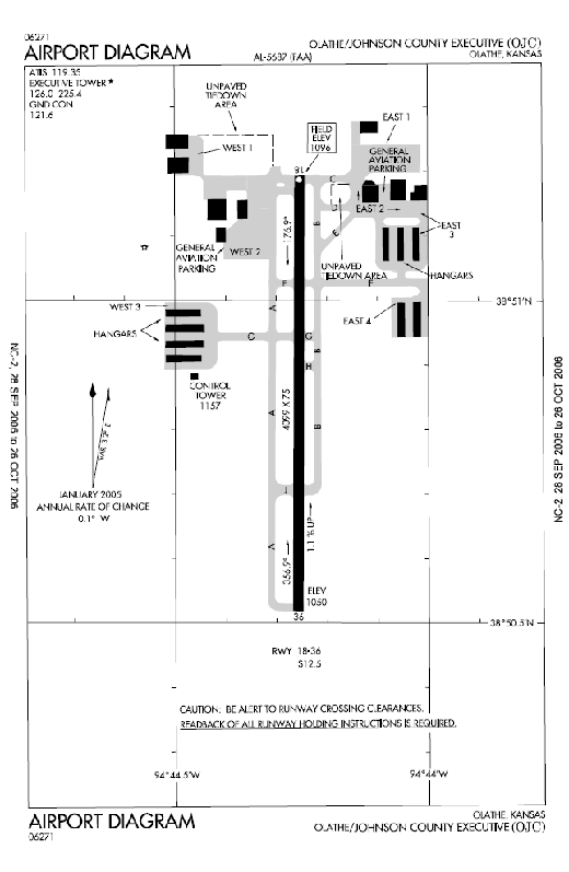
Johnson County Executive Airport covers 568 acres (230 ha) and has one runway and one helipad:
- Runway 18/36: 4,098 x 75 ft. (1,249 x 23 m), Surface: Concrete
- Helipad H1: 100 x 75 ft. (30 x 23 m), Surface: Asphalt Closed indefinitely
FBOs
Kansas City Aviation Center is an FBO at Johnson County Executive Airport and an authorized Pilatus, Piper and Diamond aircraft dealership and service center.
Air Associates of Kansas is an FBO at Johnson County Executive Airport and an authorized Cessna Service Center and Cessna Pilot Center. Air Associates provides flight training, charter, maintenance, fuel, hangar, aircraft tiedowns and pilot supplies.
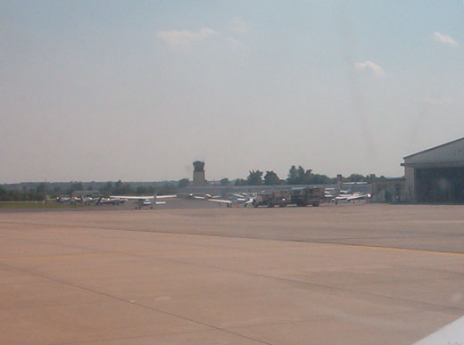 | |
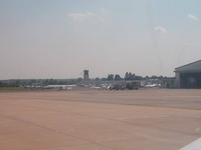
Ground view of KOJC from Taxi |
The above content comes from Wikipedia and is published under free licenses – click here to read more.
|
Location &
QuickFacts
|
FAA
Information Effective: |
2008-09-25 |
|
Airport
Identifier: |
OJC |
|
Airport
Status: |
Operational |
|
Longitude/Latitude: |
094-44-15.3090W/38-50-51.3670N
-94.737586/38.847602 (Estimated) |
|
Elevation: |
1096 ft / 334.06 m (Surveyed) |
|
Land: |
568 acres |
|
From
nearest city: |
4 nautical miles SE of Olathe, KS |
|
Location: |
Johnson County, KS |
|
Magnetic Variation: |
04E (2000) |
Owner & Manager
|
Ownership: |
Publicly owned |
|
Owner: |
Johnson County
LEE METCALFE, EXECUTIVE DIRECTOR. |
|
Address: |
1 New Century Parkway
Olathe, KS 66031 |
|
Phone
number: |
913-715-6000 |
|
Manager: |
Bob Perry |
|
Address: |
C/o Johnson County, 1 New Century Pkwy
Olathe, KS 66031 |
|
Phone number: |
913-715-6000 |
Airport Operations and Facilities
|
Airport
Use: |
Open to public |
|
Wind
indicator: |
Yes |
|
Segmented Circle: |
Yes |
|
Control
Tower: |
Yes |
|
Lighting
Schedule: |
DUSK-DAWN
ACTVT VASI RY 18; MALSR RY 36 - CTAF.
VASI RY
36 ON 24 HRS. |
|
Beacon
Color: |
Clear-Green (lighted land airport) |
|
Landing
fee charge: |
No |
|
Sectional chart: |
Kansas City |
|
Region: |
ACE - Central |
|
Boundary
ARTCC: |
ZKC - Kansas City |
|
Tie-in
FSS: |
COU - Columbia |
|
FSS on
Airport: |
No |
|
FSS Toll
Free: |
1-800-WX-BRIEF |
|
NOTAMs
Facility: |
OJC (NOTAM-d service avaliable) |
|
Federal Agreements: |
NGPY |
Airport Communications
|
CTAF: |
126.000 |
|
Unicom: |
122.950 |
Airport Services
|
Fuel
available: |
100LLA |
|
Airframe
Repair: |
MAJOR |
|
Power
Plant Repair: |
MAJOR |
|
Bottled
Oxygen: |
LOW |
|
Bulk
Oxygen: |
LOW |
|
Runway Information
Runway 18/36
|
Dimension: |
4098 x 75 ft / 1249.1 x 22.9 m |
|
Surface: |
CONC, Good Condition |
|
Weight Limit: |
Single wheel: 12500 lbs. |
|
Edge Lights: |
Medium |
|
|
Runway 18
|
Runway 36
|
|
Longitude: |
094-44-15.2438W |
094-44-15.3621W |
|
Latitude: |
38-51-11.6022N |
38-50-31.1031N |
|
Elevation: |
1096.00 ft |
1050.00 ft |
|
Alignment: |
127 |
0 |
|
ILS Type: |
LOCALIZER |
LOCALIZER |
|
Traffic
Pattern: |
Left |
Left |
|
Markings: |
Non-precision instrument, Good Condition |
Non-precision instrument, Good Condition |
|
Crossing
Height: |
25.00 ft |
40.00 ft |
|
VASI: |
2-box on right side |
4-box on left side |
|
Visual
Glide Angle: |
3.00° |
3.00° |
|
Approach
lights: |
|
MALSR |
|
Runway End
Identifier: |
No |
|
|
Obstruction: |
, 50:1 slope to clear |
21 ft tree, 925.0 ft from runway, 337 ft left of
centerline, 34:1 slope to clear |
|
Helipad H1
|
Dimension: |
100 x 75 ft / 30.5 x 22.9 m |
|
Surface: |
ASPH, Poor Condition |
|
|
Runway H1
|
Runway
|
|
Traffic
Pattern: |
Left |
Left |
|
Markings: |
None, |
, |
|
Radio Navigation Aids
|
ID |
Type |
Name |
Ch |
Freq |
Var |
Dist |
|
GQ |
NDB |
Norge |
|
517.00 |
05E |
13.4 nm |
|
GKB |
NDB |
Norge |
|
517.00 |
05E |
13.4 nm |
|
LXT |
NDB |
Lesumit |
|
263.00 |
04E |
18.4 nm |
|
DO |
NDB |
Dotte |
|
359.00 |
05E |
22.4 nm |
|
GPH |
NDB |
Mosby |
|
284.00 |
03E |
36.1 nm |
|
TO |
NDB |
Biloy |
|
521.00 |
05E |
47.3 nm |
|
FOE |
TACAN |
Forbes |
053X |
|
05E |
43.6 nm |
|
OJC |
VOR/DME |
Johnson County |
077X |
113.00 |
06E |
0.4 nm |
|
RIS |
VOR/DME |
Riverside |
051X |
111.40 |
05E |
17.7 nm |
|
MCI |
VORTAC |
Kansas City |
079Y |
113.25 |
05E |
26.3 nm |
|
ANX |
VORTAC |
Napoleon |
087X |
114.00 |
07E |
32.1 nm |
|
BUM |
VORTAC |
Butler |
106X |
115.90 |
07E |
36.5 nm |
|
TOP |
VORTAC |
Topeka |
125X |
117.80 |
05E |
41.7 nm |
|
MKC |
VOT |
Kansas City Downtown |
|
108.60 |
|
17.8 nm |
|
FOE |
VOT |
Forbes |
|
111.00 |
|
43.9 nm |
Remarks
-
UPON TAKEOFF FOR
RYS 18 & 36 MAINTAIN RY HEADING UNTIL PASSING 1,600 FT MSL.
-
ACFT EXCEEDING
12,500 LBS MUST CTC AMGR AT (913)715-6000 FOR PPR.
-
BIRDS & WATERFOWL
ON & INVOF ARPT.
-
HEL CONDS: PROVDD
APCH/DEP PATHS TO LNDG AREA MAINTD FOR MIN 8:1 GLIDE SLOPE & TRSNL SFC BE
MAINTD FOR 2:1 SLOPE.
Based Aircraft
|
Aircraft based
on field: |
143 |
|
Single Engine
Airplanes: |
120 |
|
Multi Engine
Airplanes: |
19 |
|
Jet Engine
Airplanes: |
2 |
|
Helicopters: |
2 |
Operational Statistics
Time Period: 2006-01-01 - 2006-12-31
|
Aircraft
Operations: |
194/Day |
|
Air Taxi: |
0.6% |
|
General
Aviation Local: |
34.4% |
|
General
Aviation Itinerant: |
64.8% |
|
Military: |
0.2% |
Johnson County Executive Airport
Address:
Johnson County, KS
Tel:
913-715-6000
Images
and information placed above are from
http://www.airport-data.com/airport/OJC/
We
thank them for the data!
|
General Info |
| Country |
United
States |
| State |
KANSAS
|
| FAA ID |
OJC
|
| Latitude |
38-50-51.367N |
|
Longitude |
094-44-15.309W |
|
Elevation |
1096
feet |
| Near
City |
OLATHE
|
We don't guarantee the information is fresh and accurate. The data may
be wrong or outdated.
For more up-to-date information please refer to other sources.
|
|