|
|
Independence Municipal Airport |
| Independence Municipal Airport |
 |
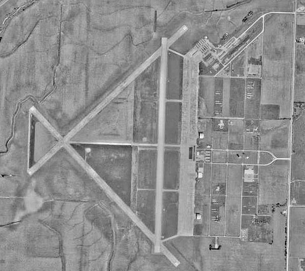
| USGS aerial image, 30 September 1991 |
| IATA: IDP â ICAO: KIDP â FAA LID: IDP |
| Summary |
| Airport type |
Public |
| Owner |
City of Independence |
| Serves |
Independence, Kansas |
| Location |
Independence Township, Montgomery County, near Independence, Kansas |
| Elevation AMSL |
825 ft / 251 m |
| Coordinates |
37°09â²30â³N 095°46â²42â³W / 37.15833°N 95.77833°W / 37.15833; -95.77833 |
| Runways |
| Direction |
Length |
Surface |
| ft |
m |
| 17/35 |
5,501 |
1,677 |
Asphalt |
| 4/22 |
3,402 |
1,037 |
Asphalt |
| Statistics (2005) |
| Aircraft operations |
10,600 |
| Source: Federal Aviation Administration |
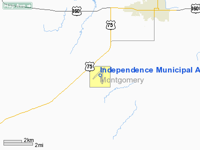
Independence Municipal Airport (IATA: IDP, ICAO: KIDP, FAA LID: IDP) is a city-owned public-use airport located 5 nautical miles (9 km) southwest of the central business district of Independence, a city in Montgomery County, Kansas, United States. History
During World War II, the facility was known as Independence Army Airfield and was used as a United States Army Air Forces Second Air Force training base for pilots. Operations started in 1942 and continued through 1945. It served as a storage facility for excess equipment and supplies after the war. The airfield was closed by the Air Force in 1947 and ownership was turned over to the City of Independence for use as a municipal airport. The Independence Municipal Airport has been annexed by the city, and also serves as one of the city's industrial parks. Industries located at the airport include Cessna and Kansas Aviation.
Facilities and aircraft
Independence Municipal Airport has an elevation of 825 feet (251 m) and covers an area of 1,433 acres (580 ha). It contains two asphalt paved runways: 17/35 measuring 5,501 x 100 ft (1,677 x 30 m) and 4/22 measuring 3,402 x 60 ft (1,037 x 18 m). For the 12-month period ending September 12, 2005, the airport had 10,600 aircraft operations, an average of 29 per day: 86% general aviation, 13% air taxi and <1% military.
The above content comes from Wikipedia and is published under free licenses – click here to read more.
|
Location &
QuickFacts
|
FAA
Information Effective: |
2008-09-25 |
|
Airport
Identifier: |
IDP |
|
Airport
Status: |
Operational |
|
Longitude/Latitude: |
095-46-42.2000W/37-09-30.1000N
-95.778389/37.158361 (Estimated) |
|
Elevation: |
825 ft / 251.46 m (Estimated) |
|
Land: |
1433 acres |
|
From
nearest city: |
5 nautical miles SW of Independence, KS |
|
Location: |
Montgomery County, KS |
|
Magnetic Variation: |
05E (2000) |
Owner & Manager
|
Ownership: |
Publicly owned |
|
Owner: |
City Of Independence |
|
Address: |
120 N. 6th
Independence, KS 67301 |
|
Phone number: |
620-332-2500 |
|
Manager: |
Gary Macy |
|
Address: |
Rr1 Box 233
Independence, KS 67301 |
|
Phone number: |
620-332-2531 |
Airport
Operations and Facilities
|
Airport
Use: |
Open to public |
|
Wind
indicator: |
Yes
WIND SOCK FADED |
|
Segmented Circle: |
Yes |
|
Control
Tower: |
Yes |
|
Lighting
Schedule: |
DUSK-DAWN
ACTVT MIRL RY 04/22 & HIRL RY 17/35; PAPI RYS 04; 17; 22 & 35; MALSR
RY 35 - CTAF. |
|
Beacon
Color: |
Clear-Green (lighted land airport) |
|
Landing
fee charge: |
No |
|
Sectional chart: |
Kansas City |
|
Region: |
ACE - Central |
|
Boundary
ARTCC: |
ZKC - Kansas City |
|
Tie-in
FSS: |
ICT - Wichita |
|
FSS on
Airport: |
No |
|
FSS Toll
Free: |
1-800-WX-BRIEF |
|
NOTAMs
Facility: |
ICT (NOTAM-d service avaliable) |
|
Federal Agreements: |
NGPY |
Airport Communications
|
CTAF: |
126.075 |
|
Unicom: |
122.700 |
Airport Services
|
Fuel
available: |
100LLA |
|
Airframe
Repair: |
NONE |
|
Power
Plant Repair: |
NONE |
|
Bottled
Oxygen: |
NONE |
|
Bulk
Oxygen: |
NONE |
|
Runway Information
Runway 04/22
|
Dimension: |
3402 x 60 ft / 1036.9 x 18.3 m |
|
Surface: |
ASPH, Good Condition |
|
Weight Limit: |
Single wheel: 24000 lbs.
Dual wheel: 30000 lbs. |
|
Edge Lights: |
Medium |
|
|
Runway 04
|
Runway 22
|
|
Longitude: |
095-47-07.5489W |
095-46-37.6881W |
|
Latitude: |
37-09-25.2400N |
37-09-48.9049N |
|
Elevation: |
821.00 ft |
820.00 ft |
|
Alignment: |
45 |
127 |
|
Traffic
Pattern: |
Left |
Left |
|
Markings: |
Non-precision instrument, Good Condition |
Non-precision instrument, Good Condition |
|
VASI: |
4-light PAPI on left side |
4-light PAPI on left side |
|
Runway 17/35
|
Dimension: |
5501 x 100 ft / 1676.7 x 30.5 m |
|
Surface: |
ASPH, Good Condition |
|
Weight Limit: |
Single wheel: 24000 lbs.
Dual wheel: 30000 lbs. |
|
Edge Lights: |
High |
|
|
Runway 17
|
Runway 35
|
|
Longitude: |
095-46-35.5953W |
095-46-35.9381W |
|
Latitude: |
37-09-53.0268N |
37-08-58.6381N |
|
Elevation: |
821.00 ft |
819.00 ft |
|
Alignment: |
127 |
0 |
|
ILS Type: |
|
ILS/DME |
|
Traffic
Pattern: |
Left |
Left |
|
Markings: |
Non-precision instrument, Good Condition |
Precision instrument, Good Condition |
|
Crossing
Height: |
0.00 ft |
45.00 ft |
|
VASI: |
4-light PAPI on left side |
4-light PAPI on left side |
|
Visual
Glide Angle: |
0.00° |
3.00° |
|
Approach
lights: |
|
MALSR |
|
Runway End
Identifier: |
Yes |
No |
|
Radio Navigation Aids
|
ID |
Type |
Name |
Ch |
Freq |
Var |
Dist |
|
CFV |
NDB |
Coffeyville |
|
212.00 |
05E |
10.7 nm |
|
PPF |
NDB |
Parsons |
|
258.00 |
06E |
16.8 nm |
|
MSB |
NDB |
Monarch |
|
410.00 |
04E |
41.8 nm |
|
BVO |
VOR/DME |
Bartlesville |
126X |
117.90 |
08E |
22.6 nm |
|
CNU |
VOR/DME |
Chanute |
029X |
109.20 |
05E |
29.5 nm |
|
OSW |
VORTAC |
Oswego |
123X |
117.60 |
08E |
27.5 nm |
Remarks
-
ULTRALIGHT ACFT
ON & INVOF ARPT.
-
RY 35 IS
DESIGNATED AS CALM WIND RY.
-
MANUFACTURED ACFT
TESTING ON & INVOF ARPT
-
CROP DUSTING ACFT
& AGRICULTURAL EQUIP ON & INVOF ARPT.
-
MIGRATORY BIRDS &
WATERFOWL ON & INVOF ARPT.
-
WILDLIFE ON & INVOF RYS.
-
NO LINE ON SIGHT
RY 04/22.
-
EXTENSIVE FLIGHT
TESTING & FLIGHT TRAINING INVOF ARPT.
-
FARM MACHINERY ON
& INVOF ARPT.
-
CROP DUSTING
ACTIVITY INVOF ARPT.
-
PRVDD A CLEAR
APCH TO EACH RY MAINTAINED FOR A MINIMUM 20:1 GLIDE SLOPE & A CLEAR
TRANSITIONAL SFC IS MAINTAINED FOR A 7:1 SLOPE.
Based Aircraft
|
Aircraft based
on field: |
64 |
|
Single Engine
Airplanes: |
57 |
|
Multi Engine
Airplanes: |
4 |
|
Jet Engine
Airplanes: |
1 |
|
Ultralights: |
2 |
Operational Statistics
Time Period: 2004-09-13 - 2005-09-12
|
Aircraft
Operations: |
204/Week |
|
Air Taxi: |
13.2% |
|
General
Aviation Local: |
48.1% |
|
General
Aviation Itinerant: |
38.2% |
|
Military: |
0.5% |
Independence Municipal Airport
Address:
Montgomery County, KS
Tel:
620-332-2500, 620-332-2531
Images
and information placed above are from
http://www.airport-data.com/airport/IDP/
We
thank them for the data!
|
General Info |
| Country |
United
States |
| State |
KANSAS
|
| FAA ID |
IDP
|
| Latitude |
37-09-30.100N |
|
Longitude |
095-46-42.200W |
|
Elevation |
825 feet
|
| Near
City |
INDEPENDENCE |
We don't guarantee the information is fresh and accurate. The data may
be wrong or outdated.
For more up-to-date information please refer to other sources.
|
|