|
|
Herington Regional Airport |
| Herington Regional Airport |
 |
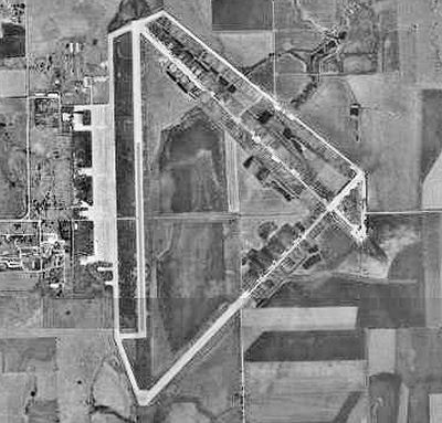
| 1991 USGS Photo |
| IATA: none â ICAO: KHRU â FAA LID: HRU |
| Summary |
| Airport type |
Public |
| Owner |
City of Herington |
| Serves |
Herington, Kansas |
| Location |
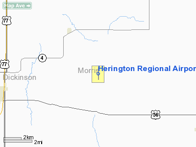
Morris County, near Herington, Kansas |
| Elevation AMSL |
1,480 ft / 451 m |
| Coordinates |
38°41â²41â³N 096°48â²29â³W / 38.69472°N 96.80806°W / 38.69472; -96.80806 |
| Runways |
| Direction |
Length |
Surface |
| ft |
m |
| 17/35 |
4,184 |
1,275 |
Asphalt |
| Statistics (2008) |
| Aircraft operations |
11,600 |
| Based aircraft |
11 |
| Source: Federal Aviation Administration |
Herington Regional Airport (ICAO: KHRU, FAA LID: HRU), formerly known as Herington Municipal Airport, is a public use airport in Morris County, Kansas, United States. The airport is owned by the City of Herington and is located seven nautical miles (13 km) northeast of its central business district. Although the airport is in Morris County, most of Herington is located in Dickinson County. The airport is located on the former site of Herington Army Airfield.
Although most U.S. airports use the same three-letter location identifier for the FAA and IATA, this airport is assigned HRU by the FAA but has no designation from the IATA. History
During World War II, the facility was known as Herington Army Airfield and was used as a United States Army Air Forces Second Air Force as a staging area for overseas deployment of heavy bombers and their crews. These bombers included B-17s, B-24s, and B-29s. The facilities at the field included runways, hangers, fuel storage tanks, barracks, administration buildings, and other related structures necessary for airfield operations. Construction started in 1942, and the field was completed over a 14 month period.
In 1945 Herington AAF was deactivated and then declared surplus in 1946. All the property was eventually disposed of and became the Herington Municipal Airport
Facilities and aircraft
Herington Regional Airport covers an area of 1,709 acres (692 ha) at an elevation of 1,480 feet (451 m) above mean sea level. It has one asphalt paved runway designated 17/35 which measures 4,184 by 75 feet (1,275 x 23 m).
For the 12-month period ending July 14, 2008, the airport had 11,600 general aviation aircraft operations, an average of 31 per day. At that time there were 11 aircraft based at this airport: 82% single-engine and 18% ultralight.
The above content comes from Wikipedia and is published under free licenses – click here to read more.
|
Location &
QuickFacts
|
FAA
Information Effective: |
2008-09-25 |
|
Airport
Identifier: |
HRU |
|
Airport
Status: |
Operational |
|
Longitude/Latitude: |
096-48-28.7230W/38-41-40.9650N
-96.807979/38.694713 (Estimated) |
|
Elevation: |
1480 ft / 451.10 m (Surveyed) |
|
Land: |
1709 acres |
|
From
nearest city: |
7 nautical miles NE of Herington, KS |
|
Location: |
Morris County, KS |
|
Magnetic Variation: |
06E (1985) |
Owner & Manager
|
Ownership: |
Publicly owned |
|
Owner: |
City Of Herington |
|
Address: |
P O Box 31
Herington, KS 67449 |
|
Phone number: |
785-258-2271 |
|
Manager: |
Merlin Oswald |
|
Address: |
3134 Us Hwy 56
Herington, KS 67449 |
|
Phone number: |
785-258-2877
AMGR NIGHTTIME PHONE 785-258-2560. |
Airport
Operations and Facilities
|
Airport
Use: |
Open to public |
|
Wind
indicator: |
Yes
TET LGT FOR NGT WITH LGTD WINDSOCK |
|
Segmented Circle: |
No |
|
Control
Tower: |
No |
|
Lighting
Schedule: |
DUSK-DAWN
ACTVT MIRL RY 17/35 - CTAF. |
|
Beacon
Color: |
Clear-Green (lighted land airport) |
|
Landing
fee charge: |
No |
|
Sectional chart: |
Kansas City |
|
Region: |
ACE - Central |
|
Traffic
Pattern Alt: |
820 ft |
|
Boundary
ARTCC: |
ZKC - Kansas City |
|
Tie-in
FSS: |
ICT - Wichita |
|
FSS on
Airport: |
No |
|
FSS Toll
Free: |
1-800-WX-BRIEF |
|
NOTAMs
Facility: |
ICT (NOTAM-d service avaliable) |
|
Federal Agreements: |
NPY |
Airport Communications
Airport Services
|
Fuel
available: |
100LL |
|
Airframe
Repair: |
NONE |
|
Power
Plant Repair: |
NONE |
|
Runway Information
Runway 17/35
|
Dimension: |
4184 x 75 ft / 1275.3 x 22.9 m |
|
Surface: |
CONC, |
|
Weight Limit: |
Single wheel: 36000 lbs.
Dual wheel: 58000 lbs. |
|
Edge Lights: |
Medium |
|
|
Runway 17
|
Runway 35
|
|
Longitude: |
096-48-28.6730W |
096-48-28.7730W |
|
Latitude: |
38-42-01.6450N |
38-41-20.2850N |
|
Elevation: |
1479.00 ft |
1477.00 ft |
|
Alignment: |
127 |
0 |
|
Traffic
Pattern: |
Left |
Left |
|
Markings: |
Non-precision instrument, Good Condition |
Non-precision instrument, Good Condition |
|
Runway End
Identifier: |
No |
No |
|
Centerline
Lights: |
No |
No |
|
Touchdown
Lights: |
No |
No |
|
Obstruction: |
, 50:1 slope to clear |
61 ft tree, 1715.0 ft from runway, 267 ft left of
centerline, 24:1 slope to clear |
|
Radio Navigation Aids
|
ID |
Type |
Name |
Ch |
Freq |
Var |
Dist |
|
HRU |
NDB |
Herington |
|
407.00 |
06E |
0.2 nm |
|
CVY |
NDB |
Cavalry |
|
314.00 |
06E |
19.9 nm |
|
MQD |
NDB |
Mc Dowell Creek |
|
391.00 |
06E |
26.7 nm |
|
EWK |
NDB |
Newton |
|
281.00 |
06E |
43.8 nm |
|
CYW |
NDB |
Clay Center |
|
362.00 |
07E |
44.4 nm |
|
MPR |
NDB |
Mc Pherson |
|
227.00 |
06E |
46.3 nm |
|
FRI |
VOR |
Fort Riley |
|
109.40 |
06E |
16.7 nm |
|
MHK |
VOR/DME |
Manhattan |
039X |
110.20 |
06E |
27.9 nm |
|
EMP |
VORTAC |
Emporia |
075X |
112.80 |
08E |
39.8 nm |
|
SLN |
VORTAC |
Salina |
118X |
117.10 |
07E |
40.5 nm |
Remarks
-
PILOTS LOUNGE PHONE NUMBER
785-258-3822.
-
PUBLIC PHONE AVBL
24 HRS IN PILOTS LOUNGE.
-
RDO-CTLD MODEL
ACFT ACTIVITY ON ARPT WKENDS & HOLS.
-
EXISTED PRIOR TO 1959.
Based Aircraft
|
Aircraft based
on field: |
11 |
|
Single Engine
Airplanes: |
9 |
|
Ultralights: |
2 |
Operational Statistics
Time Period: 2007-07-16 - 2008-07-14
|
Aircraft
Operations: |
224/Week |
|
General
Aviation Local: |
48.3% |
|
General
Aviation Itinerant: |
51.7% |
Herington Regional Airport
Address:
Morris County, KS
Tel:
785-258-2271, 785-258-2877
Images
and information placed above are from
http://www.airport-data.com/airport/HRU/
We
thank them for the data!
|
General Info |
| Country |
United
States |
| State |
KANSAS
|
| FAA ID |
HRU
|
| Latitude |
38-40-59.606N |
|
Longitude |
096-48-28.823W |
|
Elevation |
1480
feet |
| Near
City |
HERINGTON |
We don't guarantee the information is fresh and accurate. The data may
be wrong or outdated.
For more up-to-date information please refer to other sources.
|
|