 |
|
| Hays Regional Airport |
| IATA: HYS â ICAO: KHYS |
| Summary |
| Airport type |
Public |
| Operator |
City of Hays |
| Location |
Hays, Kansas |
| Elevation AMSL |
1,998 ft / 609 m |
| Coordinates |
38°50â²32â³N 99°16â²23â³W / 38.84222°N 99.27306°W / 38.84222; -99.27306Coordinates: 38°50â²32â³N 99°16â²23â³W / 38.84222°N 99.27306°W / 38.84222; -99.27306 |
| Runways |
| Direction |
Length |
Surface |
| ft |
m |
| 16/34 |
6,500 |
1,981 |
Asphalt |
| 4/22 |
4,500 |
1,372 |
Concrete |
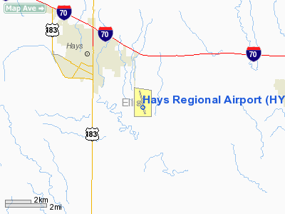
Hays Regional Airport (IATA: HYS, ICAO: KHYS, FAA LID: HYS) is a public airport located three miles (5 km) southeast of the central business district (CBD) of Hays, a city in Ellis County, Kansas, USA. The airport covers 545 acres (221 ha) and has two runways. It is mostly used for general aviation, but is also served by one commercial airline. Service is subsidized by the Essential Air Service program.
Airlines and destinations
| Airlines |
Destinations |
| Great Lakes Airlines |
Denver |
The above content comes from Wikipedia and is published under free licenses – click here to read more.
|
Location &
QuickFacts
|
FAA
Information Effective: |
2008-09-25 |
|
Airport
Identifier: |
HYS |
|
Airport
Status: |
Operational |
|
Longitude/Latitude: |
099-16-23.4170W/38-50-31.9560N
-99.273171/38.842210 (Estimated) |
|
Elevation: |
1998 ft / 608.99 m (Surveyed) |
|
Land: |
545 acres |
|
From
nearest city: |
3 nautical miles SE of Hays, KS |
|
Location: |
Ellis County, KS |
|
Magnetic Variation: |
08E (1990) |
Owner & Manager
|
Ownership: |
Publicly owned |
|
Owner: |
City Of Hays |
|
Address: |
Po Box 490
Hays, KS 67601 |
|
Phone number: |
785-628-7320 |
|
Manager: |
Terry Urban |
|
Address: |
Box 490
Hays, KS 67601 |
|
Phone number: |
785-628-7370 |
Airport
Operations and Facilities
|
Airport
Use: |
Open to public |
|
Wind
indicator: |
Yes |
|
Segmented Circle: |
Yes |
|
Control
Tower: |
No |
|
Lighting
Schedule: |
DUSK-DAWN
ACTVT MIRL RYS 16/34 AND 4/22; PAPI RYS 16, 34, 4, AND 22; REIL RYS
16, 4 AND 22 AND MALSR RY 34 - CTAF. |
|
Beacon
Color: |
Clear-Green (lighted land airport) |
|
Landing
fee charge: |
No |
|
Sectional chart: |
Wichita |
|
Region: |
ACE - Central |
|
Boundary
ARTCC: |
ZKC - Kansas City |
|
Tie-in
FSS: |
ICT - Wichita |
|
FSS on
Airport: |
No |
|
FSS Toll
Free: |
1-800-WX-BRIEF |
|
NOTAMs
Facility: |
HYS (NOTAM-d service avaliable) |
|
Certification type/date: |
II A S 05/197
ARPT CLSD TO ACR OPNS WITH MORE THAN 30 PSGR SEATS EXCP 24 HRS PPR
CALL AMGR 785-628-7370. |
|
Federal Agreements: |
NGY |
Airport Communications
|
CTAF: |
122.800 |
|
Unicom: |
122.800 |
Airport Services
|
Fuel
available: |
100LLA
< NR CALL HRS AFTER FUEL> |
|
Airframe
Repair: |
MAJOR |
|
Power
Plant Repair: |
MAJOR |
|
Bottled
Oxygen: |
NONE |
|
Bulk
Oxygen: |
NONE |
|
Runway Information
Runway 04/22
|
Dimension: |
4500 x 75 ft / 1371.6 x 22.9 m |
|
Surface: |
CONC, |
|
Weight Limit: |
Single wheel: 12500 lbs.
Dual wheel: 12500 lbs. |
|
Edge Lights: |
Medium |
|
|
Runway 04
|
Runway 22
|
|
Longitude: |
099-16-41.3012W |
099-15-58.9444W |
|
Latitude: |
38-50-07.0957N |
38-50-36.7807N |
|
Elevation: |
1980.00 ft |
1992.00 ft |
|
Alignment: |
48 |
127 |
|
Traffic
Pattern: |
Left |
Left |
|
Markings: |
Non-precision instrument, Good Condition |
Non-precision instrument, Good Condition |
|
Crossing
Height: |
40.00 ft |
38.00 ft |
|
VASI: |
4-light PAPI on left side |
4-light PAPI on left side |
|
Visual
Glide Angle: |
3.00° |
3.00° |
|
Runway End
Identifier: |
Yes |
Yes |
|
Runway 16/34
|
Dimension: |
6500 x 100 ft / 1981.2 x 30.5 m |
|
Surface: |
ASPH, |
|
Weight Limit: |
Single wheel: 28000 lbs.
Dual wheel: 48000 lbs.
Dual tandem wheel: 86000 lbs. |
|
Edge Lights: |
Medium |
|
|
Runway 16
|
Runway 34
|
|
Longitude: |
099-16-34.6700W |
099-16-16.7260W |
|
Latitude: |
38-51-10.2400N |
38-50-07.5420N |
|
Elevation: |
1998.00 ft |
1983.00 ft |
|
Alignment: |
127 |
127 |
|
ILS Type: |
|
ILS |
|
Traffic
Pattern: |
Left |
Left |
|
Markings: |
Precision instrument, Good Condition |
Precision instrument, Good Condition |
|
Crossing
Height: |
43.00 ft |
43.00 ft |
|
VASI: |
4-light PAPI on left side |
4-light PAPI on left side |
|
Visual
Glide Angle: |
3.00° |
3.00° |
|
Approach
lights: |
|
MALSR |
|
Runway End
Identifier: |
Yes |
|
|
Radio Navigation Aids
|
ID |
Type |
Name |
Ch |
Freq |
Var |
Dist |
|
HIL |
NDB |
Hilyn |
|
338.00 |
08E |
33.8 nm |
|
LQR |
NDB |
Larned |
|
296.00 |
08E |
39.3 nm |
|
HYS |
VORTAC |
Hays |
041X |
110.40 |
10E |
0.4 nm |
Based Aircraft
|
Aircraft based
on field: |
63 |
|
Single Engine
Airplanes: |
49 |
|
Multi Engine
Airplanes: |
5 |
|
Helicopters: |
1 |
|
Ultralights: |
8
ULTRALIGHT ACTIVITY ON & INVOF ARPT. |
Operational Statistics
Time Period: 2006-01-16 - 2007-01-15
|
Aircraft
Operations: |
89/Day |
|
Air Taxi: |
9.5% |
|
General
Aviation Local: |
43.5% |
|
General
Aviation Itinerant: |
46.6% |
|
Military: |
0.5% |
Hays Regional Airport
Address:
Ellis County, KS
Tel:
785-628-7320, 785-628-7370
Images
and information placed above are from
http://www.airport-data.com/airport/HYS/
We
thank them for the data!
|
General Info |
| Country |
United
States |
| State |
KANSAS
|
| FAA ID |
HYS
|
| Latitude |
38-50-41.790N |
|
Longitude |
099-16-26.521W |
|
Elevation |
1998
feet |
| Near
City |
HAYS
|
We don't guarantee the information is fresh and accurate. The data may
be wrong or outdated.
For more up-to-date information please refer to other sources.
|
|


