 |
|
Garnett Municipal Airport |
| Garnett Municipal Airport |
| IATA: none â ICAO: none â FAA LID: K68 |
| Summary |
| Airport type |
Public |
| Owner |
City of Garnett |
| Serves |
Garnett, Kansas |
| Elevation AMSL |
989 ft / 301 m |
| Coordinates |
38°16â²38â³N 095°12â²55â³W / 38.27722°N 95.21528°W / 38.27722; -95.21528 |
| Runways |
| Direction |
Length |
Surface |
| ft |
m |
| 1/19 |
2,660 |
811 |
Asphalt |
| Statistics (2008) |
| Aircraft operations |
11,060 |
| Based aircraft |
10 |
| Source: Federal Aviation Administration |
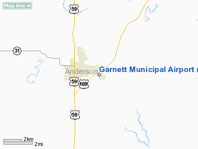
Garnett Municipal Airport (FAA LID: K68) is a city-owned public-use airport located two nautical miles (4 km) east of the central business district of Garnett, a city in Anderson County, Kansas, United States.
Facilities and aircraft
Garnett Municipal Airport covers an area of 154 acres (62 ha) at an elevation of 989 feet (301 m) above mean sea level. It has one asphalt paved runway designated 1/19 which measures 2,660 by 45 feet (811 x 14 m).
For the 12-month period ending July 24, 2008, the airport had 11,060 aircraft operations, an average of 30 per day: 99% general aviation and 1% military. At that time there were 10 aircraft based at this airport: 80% single-engine and 20% multi-engine.
The above content comes from Wikipedia and is published under free licenses – click here to read more.
|
Location &
QuickFacts
|
FAA
Information Effective: |
2008-06-05 |
|
Airport
Identifier: |
K68 |
|
Airport
Status: |
Operational |
|
Longitude/Latitude: |
095-13-00.9060W/38-16-45.0780N
-95.216918/38.279188 (Estimated) |
|
Elevation: |
989 ft / 301.45 m (Estimated) |
|
Land: |
154 acres |
|
From
nearest city: |
2 nautical miles E of Garnett, KS |
|
Location: |
Anderson County, KS |
|
Magnetic Variation: |
05E (1985) |
Owner & Manager
|
Ownership: |
Publicly owned |
|
Owner: |
City Of Garnett |
|
Address: |
131 W 5th
Garnett, KS 66032 |
|
Phone
number: |
785-448-5496 |
|
Manager: |
Garland Haynes |
|
Address: |
1202 E 4th St Road
Garnett, KS 66032 |
|
Phone
number: |
785-448-6931
ARPT OFC DURG THE DAY 785-448-6931. |
Airport
Operations and Facilities
|
Airport
Use: |
Open to public |
|
Wind
indicator: |
Yes |
|
Segmented Circle: |
No
SEGMENTED CIRCLE NOT AVBL. |
|
Control
Tower: |
No |
|
Lighting
Schedule: |
DUSK-DAWN |
|
Beacon
Color: |
Clear-Green (lighted land airport) |
|
Landing
fee charge: |
No |
|
Sectional chart: |
Kansas City |
|
Region: |
ACE - Central |
|
Boundary
ARTCC: |
ZKC - Kansas City |
|
Tie-in
FSS: |
ICT - Wichita |
|
FSS on
Airport: |
No |
|
FSS Toll
Free: |
1-800-WX-BRIEF |
|
NOTAMs
Facility: |
ICT (NOTAM-d service avaliable) |
|
Federal Agreements: |
N1 |
Airport Communications
|
CTAF: |
122.800 |
|
Unicom: |
122.800 |
Airport Services
|
Fuel
available: |
100LL
FOR FUEL AFT DUSK CALL (785) 304-2357. |
|
Airframe
Repair: |
MINOR |
|
Power
Plant Repair: |
MINOR |
|
Bottled
Oxygen: |
NONE |
|
Bulk
Oxygen: |
NONE |
|
Runway Information
Runway 01/19
|
Dimension: |
2660 x 45 ft / 810.8 x 13.7 m |
|
Surface: |
ASPH, Good Condition |
|
Edge Lights: |
Low |
|
|
Runway 01
|
Runway 19
|
|
Traffic
Pattern: |
Left |
Left |
|
Markings: |
Basic, Fair Condition
RY 01/19 PVMT ENDS MKD WITH YELLOW & WHITE PANELS. |
Basic, Fair Condition |
|
Displaced
threshold: |
92.00 ft |
135.00 ft |
|
Obstruction: |
15 ft road, 217.0 ft from runway, 1:1 slope to clear
APCH SLOPE TO DSPLCD THLD 8:1 (ROAD).
3 FT FENCE 12 FT FM THLD; +15 RD 25 FT FM THLD. |
27 ft pole, 609.0 ft from runway, 305 ft left of
centerline, 15:1 slope to clear
APCH SLOPE TO DSPLCD THLD 15:1 (ROAD).
+11 FT ROAD 30 FT FM RY END. |
|
Radio Navigation Aids
|
ID |
Type |
Name |
Ch |
Freq |
Var |
Dist |
|
UKL |
NDB |
Boyd |
|
245.00 |
05E |
23.8 nm |
|
MSB |
NDB |
Monarch |
|
410.00 |
04E |
30.8 nm |
|
FSK |
NDB |
Fort Scott |
|
379.00 |
05E |
36.0 nm |
|
FOE |
TACAN |
Forbes |
053X |
|
05E |
45.3 nm |
|
OJC |
VOR/DME |
Johnson County |
077X |
113.00 |
06E |
40.6 nm |
|
CNU |
VOR/DME |
Chanute |
029X |
109.20 |
05E |
43.1 nm |
|
BUM |
VORTAC |
Butler |
106X |
115.90 |
07E |
34.4 nm |
|
EMP |
VORTAC |
Emporia |
075X |
112.80 |
08E |
43.5 nm |
|
FOE |
VOT |
Forbes |
|
111.00 |
|
45.6 nm |
Remarks
-
IF EMERG EXIST
CALL 911 OR POLICE DESK 785-448-6823.
Based Aircraft
|
Aircraft based
on field: |
13 |
|
Single Engine
Airplanes: |
11 |
|
Multi Engine
Airplanes: |
2 |
Operational Statistics
Time Period: 2004-09-17 - 2005-09-16
|
Aircraft
Operations: |
213/Week |
|
General
Aviation Local: |
54.2% |
|
General
Aviation Itinerant: |
45.2% |
|
Military: |
0.5% |
Garnett Municipal Airport
Address:
Anderson County, KS
Tel:
785-448-5496,
785-448-6931
Images
and information placed above are from
http://www.airport-data.com/airport/K68/
We
thank them for the data!
|
General Info |
| Country |
United
States |
| State |
KANSAS
|
| FAA ID |
K68
|
| Latitude |
38-16-45.078N |
|
Longitude |
095-13-00.906W |
|
Elevation |
989 feet
|
| Near
City |
GARNETT
|
We don't guarantee the information is fresh and accurate. The data may
be wrong or outdated.
For more up-to-date information please refer to other sources.
|
|


