|
|
Gardner Municipal Airport |
| Gardner Municipal Airport |
| IATA: none â ICAO: none â FAA LID: K34 |
| Summary |
| Airport type |
Public |
| Owner/Operator |
City of Gardner |
| Location |
Gardner, Kansas |
| Elevation AMSL |
1,042 ft / 318 m |
| Coordinates |
38°48â²25â³N 094°57â²22â³W / 38.80694°N 94.95611°W / 38.80694; -94.95611 |
| Runways |
| Direction |
Length |
Surface |
| ft |
m |
| 3/21 |
2,154 |
657 |
Turf |
| 8/26 |
2,960 |
902 |
Asphalt |
| 17/35 |
3,373 |
1,028 |
Turf |
| Statistics (2004) |
| Aircraft operations |
51,500 |
| Based aircraft |
96 |
| Source: Federal Aviation Administration |
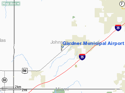
Gardner Municipal Airport (FAA LID: K34) is a public airport located one mile (2 km) west of the central business district of Gardner, a city in Johnson County, Kansas, United States. This airport is publicly owned by City of Gardner.
Facilities and aircraft
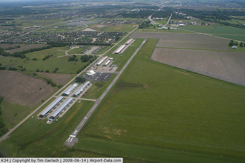
Gardner Municipal Airport covers an area of 129 acres (52 ha) which contains three runways:
- Runway 3/21: 2,154 x 80 ft (657 x 24 m), Surface: Turf
- Runway 8/26: 2,960 x 39 ft (902 x 12 m), Surface: Asphalt
- Runway 17/35: 3,373 x 90 ft (1,028 x 27 m), Surface: Turf
For 12-month period ending April 30, 2004, the airport had 51,500 general aviation aircraft operations, an average of 141 per day. There are 96 aircraft based at this airport: 90 single engine, 4 ultralights and 2 gliders.
The above content comes from Wikipedia and is published under free licenses – click here to read more.
|
 |
(Click on the photo to enlarge) |
|
Location &
QuickFacts
|
FAA
Information Effective: |
2008-06-05 |
|
Airport
Identifier: |
K34 |
|
Airport
Status: |
Operational |
|
Longitude/Latitude: |
094-57-22.2200W/38-48-24.8600N
-94.956172/38.806906 (Estimated) |
|
Elevation: |
1042 ft / 317.60 m (Surveyed) |
|
Land: |
129 acres |
|
From
nearest city: |
1 nautical miles W of Gardner, KS |
|
Location: |
Johnson County, KS |
|
Magnetic Variation: |
05E (1990) |
Owner & Manager
|
Ownership: |
Publicly owned |
|
Owner: |
City Of Gardner
DAVE GREEN, DIR OF PUBLIC WORKS. |
|
Address: |
City Hall 120 E Main
Gardner, KS 66030 |
|
Phone
number: |
913-856-7535 |
|
Manager: |
Richard Mcnett |
|
Address: |
31905 W 175 St
Gardner, KS 66030 |
|
Phone
number: |
913-856-8659
RICHARD MCNETT ARPT MGR HOME PH. 913-856-2805. FBO 913-856-4039. FAX
913-856-4552. |
Airport Operations and Facilities
|
Airport
Use: |
Open to public |
|
Wind
indicator: |
Yes |
|
Segmented Circle: |
No |
|
Control
Tower: |
No |
|
Lighting
Schedule: |
DUSK-DAWN
ACTVT LIRL RYS 08/26 AND 17/35 - CTAF. |
|
Beacon
Color: |
Clear-Green (lighted land airport) |
|
Landing
fee charge: |
No |
|
Sectional chart: |
Kansas City |
|
Region: |
ACE - Central |
|
Boundary
ARTCC: |
ZKC - Kansas City |
|
Tie-in
FSS: |
COU - Columbia |
|
FSS on
Airport: |
No |
|
FSS Toll
Free: |
1-800-WX-BRIEF |
|
NOTAMs
Facility: |
COU (NOTAM-d service avaliable) |
|
Federal Agreements: |
NR |
Airport Communications
|
CTAF: |
122.800 |
|
Unicom: |
122.800 |
Airport Services
|
Fuel
available: |
100LL80 MOGAS
87 OCTANE UNLEADED AUTO GAS. |
|
Power
Plant Repair: |
MAJOR |
|
Runway Information
Runway 03/21
|
Dimension: |
2154 x 80 ft / 656.5 x 24.4 m |
|
Surface: |
TURF, Good Condition |
|
|
Runway 03
|
Runway 21
|
|
Longitude: |
094-57-33.0600W |
094-57-16.1100W |
|
Latitude: |
38-48-08.2900N |
38-48-24.9400N |
|
Alignment: |
39 |
127 |
|
Traffic
Pattern: |
Left |
Left |
|
Obstruction: |
32 ft trees, 572.0 ft from runway, 85 ft right of
centerline, 17:1 slope to clear |
58 ft pole, 1779.0 ft from runway, 171 ft left of
centerline, 30:1 slope to clear |
|
Runway 08/26
|
Dimension: |
2960 x 39 ft / 902.2 x 11.9 m |
|
Surface: |
ASPH, Fair Condition |
|
Weight Limit: |
Single wheel: 6000 lbs. |
|
Edge Lights: |
Non-standard lighting system
NSTD LIRL, NO RY END LGTS, NO DSPLCD THLD LGTS RY 26, & LGTS PLACED 35 FT
OUT FM RY EDGE AT 240 FT SPACINGS. |
|
|
Runway 08
|
Runway 26
|
|
Longitude: |
094-57-32.2380W |
094-56-54.8750W |
|
Latitude: |
38-48-35.8190N |
38-48-35.7270N |
|
Elevation: |
1029.00 ft |
1032.00 ft |
|
Alignment: |
90 |
127 |
|
Traffic
Pattern: |
Left |
Left |
|
Markings: |
Numbers only, Poor Condition
MARKINGS BADLY FADED. |
Numbers only, Poor Condition
MARKINGS BADLY FADED. |
|
Displaced
threshold: |
0.00 ft |
254.00 ft |
|
Obstruction: |
56 ft pline, 1550.0 ft from runway, 24:1 slope to clear
+3 FT FENCE 150 FT FM AER 08. |
58 ft tree, 1254.0 ft from runway, 5 ft left of
centerline, 18:1 slope to clear
DSPLCD THLD APCH RATIO 26:1. |
|
Runway 17/35
|
Dimension: |
3373 x 90 ft / 1028.1 x 27.4 m |
|
Surface: |
TURF, Good Condition |
|
Weight Limit: |
Dual tandem wheel: 30000 lbs. |
|
Edge Lights: |
Low
NSTD LIRL, NO RY END LGTS, NO DSPLCD THLD LGTS RY 26, & LGTS PLACED 35 FT
OUT FM RY EDGE AT 240 FT SPACINGS. |
|
|
Runway 17
|
Runway 35
|
|
Longitude: |
094-57-31.8760W |
094-57-31.8760W |
|
Latitude: |
38-48-35.0260N |
38-48-03.0270N |
|
Elevation: |
1029.00 ft |
1049.00 ft |
|
Traffic
Pattern: |
Left |
Left |
|
Obstruction: |
32 ft tree, 578.0 ft from runway, 20 ft left of
centerline, 18:1 slope to clear |
50 ft trees, 544.0 ft from runway, 10 ft right of
centerline, 10:1 slope to clear |
|
Radio Navigation Aids
|
ID |
Type |
Name |
Ch |
Freq |
Var |
Dist |
|
GKB |
NDB |
Norge |
|
517.00 |
05E |
20.8 nm |
|
GQ |
NDB |
Norge |
|
517.00 |
05E |
20.8 nm |
|
DO |
NDB |
Dotte |
|
359.00 |
05E |
26.7 nm |
|
LXT |
NDB |
Lesumit |
|
263.00 |
04E |
28.9 nm |
|
TO |
NDB |
Biloy |
|
521.00 |
05E |
39.0 nm |
|
GPH |
NDB |
Mosby |
|
284.00 |
03E |
44.3 nm |
|
UKL |
NDB |
Boyd |
|
245.00 |
05E |
47.2 nm |
|
FOE |
TACAN |
Forbes |
053X |
|
05E |
34.1 nm |
|
OJC |
VOR/DME |
Johnson County |
077X |
113.00 |
06E |
10.5 nm |
|
RIS |
VOR/DME |
Riverside |
051X |
111.40 |
05E |
25.2 nm |
|
MCI |
VORTAC |
Kansas City |
079Y |
113.25 |
05E |
30.5 nm |
|
TOP |
VORTAC |
Topeka |
125X |
117.80 |
05E |
34.1 nm |
|
BUM |
VORTAC |
Butler |
106X |
115.90 |
07E |
39.0 nm |
|
ANX |
VORTAC |
Napoleon |
087X |
114.00 |
07E |
42.4 nm |
|
MKC |
VOT |
Kansas City Downtown |
|
108.60 |
|
25.3 nm |
|
FOE |
VOT |
Forbes |
|
111.00 |
|
34.4 nm |
Remarks
-
GLIDER &
ULTRALIGHT ACTIVITY ON & INVOF ARPT.
-
FUEL AVBL 24 HRS
W/CREDIT CARD.
-
PROVIDED THE
APPROACH TO EACH RWY IS MAINTAINED FOR A MINIMUM 20:1 GLIDE SLOPE AND THE
TRANSITIONAL SURFACE BE MAINTAINED FOR A 7:1 SLOPE.
Based Aircraft
|
Aircraft based
on field: |
108 |
|
Single Engine
Airplanes: |
101 |
|
Gliders: |
4 |
|
Ultralights: |
3 |
Operational Statistics
Time Period: 2006-07-01 - 2007-06-30
|
Aircraft
Operations: |
72/Day |
|
General
Aviation Local: |
70.0% |
|
General
Aviation Itinerant: |
30.0% |
Gardner Municipal Airport
Address:
Johnson County, KS
Tel:
913-856-7535,
913-856-8659
Fax:
913-856-4552
Images
and information placed above are from
http://www.airport-data.com/airport/K34/
We
thank them for the data!
|
General Info |
| Country |
United
States |
| State |
KANSAS
|
| FAA ID |
K34
|
| Latitude |
38-48-24.860N |
|
Longitude |
094-57-22.220W |
|
Elevation |
1042
feet |
| Near
City |
GARDNER
|
We don't guarantee the information is fresh and accurate. The data may
be wrong or outdated.
For more up-to-date information please refer to other sources.
|
|