|
|
Coordinates: 38°57â²03â³N 095°39â²49â³W / 38.95083°N 95.66361°W / 38.95083; -95.66361
| Forbes Field |
 |
| IATA: FOE â ICAO: KFOE â FAA LID: FOE |
| Summary |
| Airport type |
Public |
| Owner |
Metropolitan Topeka Airport Authority |
| Serves |
Topeka, Kansas |
| Elevation AMSL |
1,078 ft / 329 m |
| Runways |
| Direction |
Length |
Surface |
| ft |
m |
| 13/31 |
12,802 |
3,902 |
Concrete |
| 3/21 |
7,000 |
2,134 |
Concrete |
| Statistics (2007) |
| Aircraft operations |
44,152 |
| Based aircraft |
57 |
| Source: Federal Aviation Administration |
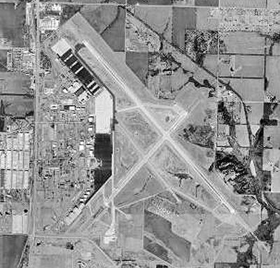
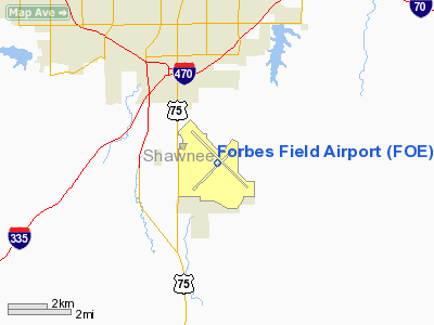
Forbes Field (IATA: FOE, ICAO: KFOE, FAA LID: FOE) is a joint civil-military public airport located six miles (10 km) south of the central business district of Topeka, a city in Shawnee County, Kansas, United States. It is owned by the Metropolitan Topeka Airport Authority.
The airport is on the former site of the Topeka Army Airfield, later known as Forbes Air Force Base, a former Strategic Air Command (SAC) facility which closed in 1973. Most of the former base administrative area is now used for offices and an industrial park. The 190th Air Refueling Wing (190 ARW) of the Kansas Air National Guard also uses a portion of the airport as an Air Force cantonment area and Air National Guard installation in support of KC-135 Stratotanker aircraft operations.
As per Federal Aviation Administration records, the airport had 17,924 passenger boardings (enplanements) in calendar year 2006, up from 7,530 enplanements in 2005. The airport has no scheduled commercial airline service at this time. Allegiant Air offered scheduled flights to Las Vegas, but discontinued service here on July 30, 2007. History
In April 1976, with the exception of those portions retained by the Air National Guard, most of the former Forbes Air Force Base was turned over to the city of Topeka and Shawnee County. During this transition, all commercial air service was moved from the Phillip Billard Airport to the newly established Forbes Field. On June 1, 1976, Frontier Airlines provided the first jet service out of Forbes Field. In 1981, a bond to build a new air terminal was rejected, but then approved a year later in 1982. The new $5 million terminal was completed in 1985. The terminal includes 5 airline ticket counters, the only current counter used is by Allegiant Air, 2 rental car counter, Hertz and Avis (seen outside in the parking lot with spaces provided for rental cars at one time), and one baggage claim carousel. Topeka has had several carriers throughout the mid-1970s to late-1980s, including Frontier, United, Midway and TWA. During this period, Forbes Field handled up to 180,000 passengers per year. After the major carriers pulled out, commuter flights were offered out of Forbes Field. As recently as November 2003, commuter service was provided by Air Midwest, codeshared with US Airways Express, on 19-passenger planes between Topeka and Kansas City International Airport.
Facilities and aircraft
Forbes Field covers an area of 2,854 acres (1,155 ha) which contains two concrete paved runways: 13/31 measuring 12,802 x 200 ft (3,902 x 61 m) and 3/21 measuring 7,000 x 150 ft (2,134 x 46 m). For the 12-month period ending October 31, 2007, the airport had 44,152 aircraft operations, an average of 120 per day: 58% military, 38% general aviation and 4% scheduled commercial.
The above content comes from Wikipedia and is published under free licenses – click here to read more.
|
Location &
QuickFacts
|
FAA
Information Effective: |
2008-06-05 |
|
Airport
Identifier: |
FOE |
|
Airport
Status: |
Operational |
|
Longitude/Latitude: |
095-39-49.0000W/38-57-03.4000N
-95.663611/38.950944 (Estimated) |
|
Elevation: |
1078 ft / 328.57 m (Surveyed) |
|
Land: |
2854 acres |
|
From
nearest city: |
6 nautical miles S of Topeka, KS |
|
Location: |
Shawnee County, KS |
|
Magnetic Variation: |
05E (1990) |
Owner & Manager
|
Ownership: |
Publicly owned |
|
Owner: |
Metropolitan Topeka Arpt Auth |
|
Address: |
Po Box 19053
Topeka, KS 66619 |
|
Phone number: |
785-862-2362 |
|
Manager: |
Michael R. Humberd |
|
Address: |
Po Box 19053
Topeka, KS 66619 |
|
Phone number: |
785-862-2362 |
Airport
Operations and Facilities
|
Airport
Use: |
Open to public |
|
Wind
indicator: |
Yes |
|
Segmented Circle: |
No |
|
Control
Tower: |
Yes |
|
Lighting
Schedule: |
DUSK-DAWN
WHEN ATCT CLSD ACTVT MIRL RY 03/21; VASI RYS 03 & 21; HIRL RY 13/31;
MALSR RY 31 - CTAF. |
|
Beacon
Color: |
Split-Clear-Green (lighted military airport) |
|
Landing
fee charge: |
No |
|
Sectional chart: |
Kansas City |
|
Region: |
ACE - Central |
|
Boundary
ARTCC: |
ZKC - Kansas City |
|
Tie-in
FSS: |
ICT - Wichita |
|
FSS on
Airport: |
No |
|
FSS Toll
Free: |
1-800-WX-BRIEF |
|
NOTAMs
Facility: |
FOE (NOTAM-d service avaliable) |
|
Certification type/date: |
I B S 04/1976
PPR 24 HRS FOR UNSCHEDULED AIR CARRIER OPERATIONS WITH MORE THAN 30
PASSENGER SEATS, CALL ARPT MGR 785-862-2362. |
|
Federal Agreements: |
NGPY |
Airport Communications
|
CTAF: |
120.800 |
|
Unicom: |
122.950 |
Airport Services
|
Fuel
available: |
100LLA |
|
Airframe
Repair: |
MAJOR |
|
Power
Plant Repair: |
MAJOR |
|
Bottled
Oxygen: |
NONE |
|
Bulk
Oxygen: |
NONE |
|
Runway Information
Runway 03/21
|
Dimension: |
7000 x 150 ft / 2133.6 x 45.7 m |
|
Surface: |
CONC, Good Condition |
|
Surface
Treatment: |
Saw-cut or plastic Grooved |
|
Weight Limit: |
Single wheel: 75000 lbs.
Dual wheel: 140000 lbs.
Dual tandem wheel: 220000 lbs.
Dual dual tandem wheel: 620000 lbs. |
|
Edge Lights: |
Medium |
|
|
Runway 03
|
Runway 21
|
|
Longitude: |
095-40-23.2867W |
095-39-26.5516W |
|
Latitude: |
38-56-25.3782N |
38-57-18.5228N |
|
Elevation: |
1078.00 ft |
1043.00 ft |
|
Alignment: |
40 |
127 |
|
Traffic
Pattern: |
Right |
Left |
|
Markings: |
Non-precision instrument, Good Condition |
Non-precision instrument, Good Condition |
|
Crossing
Height: |
51.00 ft |
53.00 ft |
|
VASI: |
4-box on left side |
4-box on left side |
|
Visual
Glide Angle: |
3.00° |
3.00° |
|
Runway End
Identifier: |
Yes |
Yes |
|
Obstruction: |
, 50:1 slope to clear |
36 ft tree, 1850.0 ft from runway, 200 ft right of
centerline, 45:1 slope to clear |
|
Runway 13/31
|
Dimension: |
12802 x 200 ft / 3902.0 x 61.0 m |
|
Surface: |
CONC, Good Condition |
|
Surface
Treatment: |
Saw-cut or plastic Grooved |
|
Weight Limit: |
Single wheel: 75000 lbs.
Dual wheel: 200000 lbs.
Dual tandem wheel: 280000 lbs.
Dual dual tandem wheel: 760000 lbs. |
|
Edge Lights: |
High |
|
|
Runway 13
|
Runway 31
|
|
Longitude: |
095-40-40.9801W |
095-38-50.5629W |
|
Latitude: |
38-57-56.0067N |
38-56-23.3936N |
|
Elevation: |
1063.00 ft |
1036.00 ft |
|
Alignment: |
127 |
127 |
|
ILS Type: |
|
ILS/DME |
|
Traffic
Pattern: |
Right |
Left |
|
Markings: |
Precision instrument, Fair Condition |
Precision instrument, Fair Condition |
|
Crossing
Height: |
52.00 ft |
57.00 ft |
|
VASI: |
4-box on left side |
4-box on left side |
|
Visual
Glide Angle: |
3.00° |
3.00° |
|
RVR
Equipment: |
|
touchdown |
|
Approach
lights: |
SALS |
MALSR |
|
Runway End
Identifier: |
Yes |
|
|
Obstruction: |
35 ft tree, 1750.0 ft from runway, 300 ft left of
centerline, 44:1 slope to clear |
59 ft tree, 2900.0 ft from runway, 500 ft left of
centerline, 45:1 slope to clear |
|
Radio Navigation Aids
|
ID |
Type |
Name |
Ch |
Freq |
Var |
Dist |
|
TO |
NDB |
Biloy |
|
521.00 |
05E |
10.2 nm |
|
UKL |
NDB |
Boyd |
|
245.00 |
05E |
39.2 nm |
|
DO |
NDB |
Dotte |
|
359.00 |
05E |
45.6 nm |
|
MQD |
NDB |
Mc Dowell Creek |
|
391.00 |
06E |
46.2 nm |
|
GKB |
NDB |
Norge |
|
517.00 |
05E |
47.5 nm |
|
GQ |
NDB |
Norge |
|
517.00 |
05E |
47.5 nm |
|
FOE |
TACAN |
Forbes |
053X |
|
05E |
0.2 nm |
|
OJC |
VOR/DME |
Johnson County |
077X |
113.00 |
06E |
43.9 nm |
|
MHK |
VOR/DME |
Manhattan |
039X |
110.20 |
06E |
48.4 nm |
|
TOP |
VORTAC |
Topeka |
125X |
117.80 |
05E |
12.4 nm |
|
EMP |
VORTAC |
Emporia |
075X |
112.80 |
08E |
45.5 nm |
|
MCI |
VORTAC |
Kansas City |
079Y |
113.25 |
05E |
47.7 nm |
|
FOE |
VOT |
Forbes |
|
111.00 |
|
0.2 nm |
Remarks
-
RY BEARING
CAPACITY - RY 03/21 - DC10-386; L1011-317.
RY 13/31 - DC10-490;
L1011-400.
-
JASU:
14(A/M32A-86D) 11(A/M32A-95)
-
FUEL: A+ (MILLION
AIRTOPEKA,1200-0400Z++, C785-862-0950; OT 3 HR PN RQR,
C785-862-6104/785-224-2899.)
J8(MIL)
-
FLUID: ADI SP
LPOX LOX OIL - O-128-148(MIL) - AVBL ONLY IN QT CANS.
-
CAUTION: DO NOT
MISTAKE PHILIP BILLARD MUNI, LCTD 7 NM N HDG 010, FOR FORBES FLD. 135' CRANE
1.69 NM NW OF ARPT MRK DAYLT.
-
NSABTMT: VFR TFC
AVOID OVFT OF HSG AREA 2 NM W RWY 13.
-
MISC: RWY 13-31 GROOVED.
-
ANG: PPR FOR ANG
RAMP AND SVC DSN 720-4720/4663, NO LATER THAN 72 HR. PRIOR. BASE OPS, MAINT
OPR CTL AND POL AVBL 1330-2200Z++ WKD, CLSD WKEND AND FEDERAL HOL. SVC MAY BE
AVBL OT, ACFT PRK ON ANG RAMP, CTC WYLIE CTRL 20 MIN PRIOR TO LDG, ADVS PM ARR
AMD DE[ UHF 286.5.
LTD TRAN SVC AVBL AT FBO.
-
ANG CONT:TRAN
MAINT AND PARTS SUPPORT (EXC KC-135E ACFT) EXTREMELY LTD.
NO QTRS AVBL.
-
ANG CONT: DEICING
FLUID NOT AVBL TO TRAN ACFT. NO FLEET SVC AVBL. OIL (SOAP) SAMPLING NOT AVBL.
NO DRAG CHUTE REPACK AVBL. PRECISION MEASURING EQPT LABORATORY PICKUP AND DEL
EXP 1.5 HR DELAY.
-
TFC PTN: 1000 FT
AGL FOR LGT (SLOW) ACFT & 1500 FT FOR HEAVY (FAST) ACFT.
-
ARNG: OPR
1300-2300Z++TUE-FRI EXC HOL, OCNL SAT, SUN. LTD MAINT UH-60A. TRANS ARMY ACFT
CTC OPS DSN 720-8725, C785-274-1725.
ARMY ACFT CTC ARNG OPS 41.70.
-
CAUTION: BIRD HAZ
PHASE II MAR-MAY & SEP-NOV.
-
LARGE & SMALL
MIGRATORY BIRDS ON & INVOF ARPT.
Based Aircraft
|
Aircraft based
on field: |
57 |
|
Single Engine
Airplanes: |
15 |
|
Multi Engine
Airplanes: |
5 |
|
Jet Engine
Airplanes: |
6 |
|
Helicopters: |
13 |
|
Military: |
18 |
Operational Statistics
Time Period: 2006-10-31 - 2007-10-31
|
Aircraft
Operations: |
121/Day |
|
Commerical: |
3.8% |
|
General
Aviation Local: |
28.5% |
|
General
Aviation Itinerant: |
9.2% |
|
Military: |
58.4% |
Forbes Field Airport
Address:
Shawnee County, KS
Tel:
785-862-2362
Images
and information placed above are from
http://www.airport-data.com/airport/FOE/
We
thank them for the data!
|
General Info |
| Country |
United
States |
| State |
KANSAS
|
| FAA ID |
FOE
|
| Latitude |
38-57-03.400N |
|
Longitude |
095-39-49.000W |
|
Elevation |
1078
feet |
| Near
City |
TOPEKA
|
We don't guarantee the information is fresh and accurate. The data may
be wrong or outdated.
For more up-to-date information please refer to other sources.
|
|