|
|
Emporia Municipal Airport |
| Emporia Municipal Airport |
| IATA: EMP â ICAO: KEMP â FAA LID: EMP |
| Summary |
| Airport type |
Public |
| Owner |
City of Emporia |
| Serves |
Emporia, Kansas |
| Elevation AMSL |
1,208 ft / 368 m |
| Coordinates |
38°19â²56â³N 096°11â²28â³W / 38.33222°N 96.19111°W / 38.33222; -96.19111 |
| Runways |
| Direction |
Length |
Surface |
| ft |
m |
| 1/19 |
4,999 |
1,524 |
Asphalt |
| 6/24 |
3,875 |
1,181 |
Turf |
| Statistics (2006) |
| Aircraft operations |
31,250 |
| Based aircraft |
45 |
| Source: Federal Aviation Administration |
Emporia Municipal Airport (IATA: EMP, ICAO: KEMP, FAA LID: EMP) is a city-owned public-use airport located four nautical miles (7 km) south of the central business district of Emporia, a city in Lyon County, Kansas, United States.
Facilities and aircraft
Emporia Municipal Airport covers an area of 650 acres (263 ha) at an elevation of 1,208 feet (368 m) above mean sea level. It has two runways: 1/19 is 4,999 by 100 feet (1,524 x 30 m) with an asphalt pavement and 6/24 is 3,875 by 298 feet (1,181 x 91 m) with a turf surface.
For the 12-month period ending October 31, 2006, the airport had 31,250 aircraft operations, an average of 85 per day: 96% general aviation, 3% air taxi and 1% military. At that time there were 45 aircraft based at this airport: 67% single-engine, 7% multi-engine, 2% jet, 2% helicopter and 22% ultralight.
The above content comes from Wikipedia and is published under free licenses – click here to read more.
|
 |
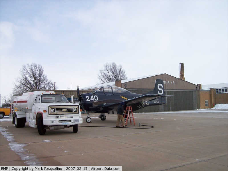
(Click on the photo to enlarge) |
|
 |
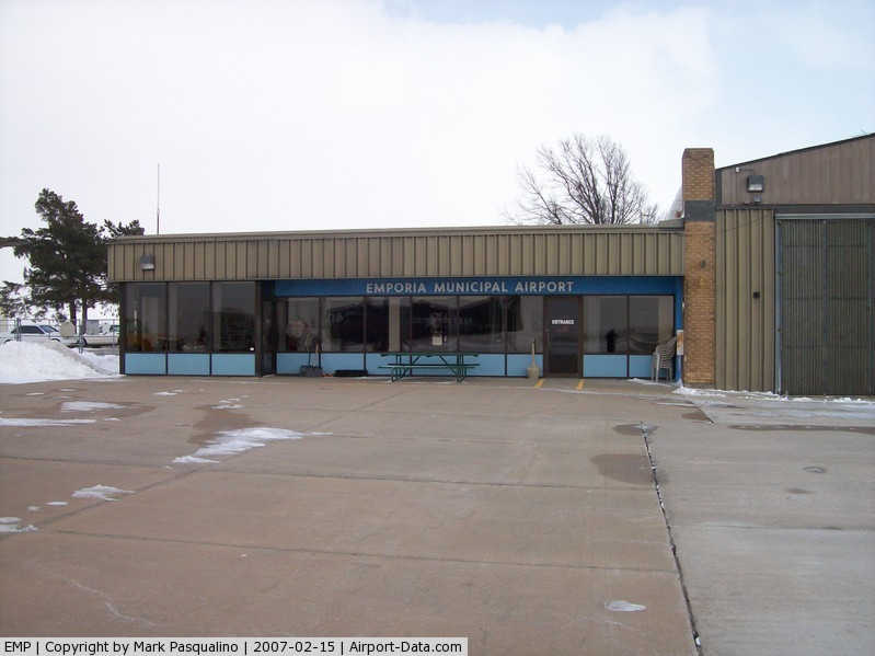
(Click on the photo to enlarge) |
|
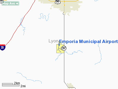
Location &
QuickFacts
|
FAA
Information Effective: |
2008-06-05 |
|
Airport
Identifier: |
EMP |
|
Airport
Status: |
Operational |
|
Longitude/Latitude: |
096-11-28.2000W/38-19-55.6000N
-96.191167/38.332111 (Estimated) |
|
Elevation: |
1208 ft / 368.20 m (Surveyed) |
|
Land: |
650 acres |
|
From
nearest city: |
4 nautical miles S of Emporia, KS |
|
Location: |
Lyon County, KS |
|
Magnetic Variation: |
05E (2000) |
Owner & Manager
|
Ownership: |
Publicly owned |
|
Owner: |
City Of Emporia
ACTG CITY MGR, MARK MCANARNEY |
|
Address: |
P O Box 928
Emporia, KS 66801 |
|
Phone number: |
620-342-5105 |
|
Manager: |
Don Tevis |
|
Address: |
1005 County Rd 120
Emporia, KS 66801 |
|
Phone number: |
620-342-3598 |
Airport
Operations and Facilities
|
Airport
Use: |
Open to public |
|
Wind
indicator: |
Yes |
|
Segmented Circle: |
Yes |
|
Control
Tower: |
No |
|
Lighting
Schedule: |
DUSK-DAWN
ACTVT PAPI & REIL RYS 01 & 19 - CTAF. ACTVT MIRL RY 01/19 AFT 1800 -
CTAF. |
|
Beacon
Color: |
Clear-Green (lighted land airport) |
|
Landing
fee charge: |
No |
|
Sectional chart: |
Kansas City |
|
Region: |
ACE - Central |
|
Boundary
ARTCC: |
ZKC - Kansas City |
|
Tie-in
FSS: |
ICT - Wichita |
|
FSS on
Airport: |
No |
|
FSS Toll
Free: |
1-800-WX-BRIEF |
|
NOTAMs
Facility: |
EMP (NOTAM-d service avaliable) |
|
Federal Agreements: |
NGY |
Airport Communications
|
CTAF: |
122.800 |
|
Unicom: |
122.800 |
Airport Services
|
Fuel
available: |
100LLA MOGAS
24 HR FUEL AVBL FOR MOGAS & 100LL. |
|
Airframe
Repair: |
MAJOR |
|
Power
Plant Repair: |
MAJOR |
|
Bottled
Oxygen: |
NONE |
|
Bulk
Oxygen: |
NONE |
|
Runway Information
Runway 01/19
|
Dimension: |
4999 x 100 ft / 1523.7 x 30.5 m |
|
Surface: |
ASPH, Good Condition
SOFT WHEN WET. |
|
Weight Limit: |
Single wheel: 30000 lbs.
Dual wheel: 45000 lbs. |
|
Edge Lights: |
Medium |
|
|
Runway 01
|
Runway 19
|
|
Longitude: |
096-11-34.8040W |
096-11-21.6700W |
|
Latitude: |
38-19-31.4830N |
38-20-19.8010N |
|
Elevation: |
1204.00 ft |
1193.00 ft |
|
Alignment: |
12 |
127 |
|
Traffic
Pattern: |
Left |
Left |
|
Markings: |
Non-precision instrument, Fair Condition |
Non-precision instrument, Fair Condition |
|
Crossing
Height: |
52.00 ft |
52.00 ft |
|
VASI: |
4-light PAPI on left side |
4-light PAPI on left side |
|
Visual
Glide Angle: |
3.00° |
3.00° |
|
Runway End
Identifier: |
Yes |
Yes |
|
Obstruction: |
25 ft tree, 844.0 ft from runway, 266 ft right of
centerline, 25:1 slope to clear |
24 ft tree, 1124.0 ft from runway, 148 ft right of
centerline, 38:1 slope to clear |
|
Runway 06/24
|
Dimension: |
3875 x 298 ft / 1181.1 x 90.8 m |
|
Surface: |
TURF, Good Condition
SOFT WHEN WET. |
|
|
Runway 06
|
Runway 24
|
|
Longitude: |
096-11-39.9860W |
096-10-55.9850W |
|
Latitude: |
38-19-34.0570N |
38-19-51.0560N |
|
Elevation: |
1200.00 ft |
1200.00 ft |
|
Traffic
Pattern: |
Left |
Left |
|
Obstruction: |
, 50:1 slope to clear |
18 ft road, 500.0 ft from runway, 27:1 slope to clear |
|
Radio Navigation Aids
|
ID |
Type |
Name |
Ch |
Freq |
Var |
Dist |
|
UKL |
NDB |
Boyd |
|
245.00 |
05E |
22.2 nm |
|
HRU |
NDB |
Herington |
|
407.00 |
06E |
36.3 nm |
|
EQA |
NDB |
El Dorado |
|
383.00 |
05E |
44.5 nm |
|
MSB |
NDB |
Monarch |
|
410.00 |
04E |
49.0 nm |
|
FOE |
TACAN |
Forbes |
053X |
|
05E |
44.6 nm |
|
FRI |
VOR |
Fort Riley |
|
109.40 |
06E |
49.6 nm |
|
EMP |
VORTAC |
Emporia |
075X |
112.80 |
08E |
3.5 nm |
|
FOE |
VOT |
Forbes |
|
111.00 |
|
44.6 nm |
Remarks
-
ULTRALIGHT ACTVTY
ON & INVOF ARPT.
-
ASOS MAST 27 FT
AGL LCTD APRXLY 700 FT W OF RY 01/19 & 1,150 FT N OF AER 01.
Based Aircraft
|
Aircraft based
on field: |
48 |
|
Single Engine
Airplanes: |
33 |
|
Multi Engine
Airplanes: |
4 |
|
Jet Engine
Airplanes: |
1 |
|
Ultralights: |
10 |
Operational Statistics
Time Period: 2005-11-01 - 2006-10-31
|
Aircraft
Operations: |
86/Day |
|
Air Taxi: |
3.2% |
|
General
Aviation Local: |
48.0% |
|
General
Aviation Itinerant: |
48.0% |
|
Military: |
0.8% |
Emporia Municipal Airport
Address:
Lyon County, KS
Tel:
620-342-5105, 620-342-3598
Images
and information placed above are from
http://www.airport-data.com/airport/EMP/
We
thank them for the data!
|
General Info |
| Country |
United
States |
| State |
KANSAS
|
| FAA ID |
EMP
|
| Latitude |
38-19-55.600N |
|
Longitude |
096-11-28.200W |
|
Elevation |
1208
feet |
| Near
City |
EMPORIA
|
We don't guarantee the information is fresh and accurate. The data may
be wrong or outdated.
For more up-to-date information please refer to other sources.
|
|