 |
|
|
Location &
QuickFacts
|
FAA
Information Effective: |
2008-06-05 |
|
Airport
Identifier: |
SN69 |
|
Airport
Status: |
Operational |
|
Longitude/Latitude: |
094-38-33.8500W/37-55-53.1350N
-94.642736/37.931426 (Estimated) |
|
Elevation: |
860 ft / 262.13 m (Estimated) |
|
Land: |
0 acres |
|
From
nearest city: |
3 nautical miles E of Hammond, KS |
|
Location: |
Bourbon County, KS |
|
Magnetic Variation: |
05E (1985) |
Owner & Manager
|
Ownership: |
Privately owned |
|
Owner: |
James Emmerson/fred Emmerson |
|
Address: |
Rr 1
Fort Scott, KS 66701 |
|
Phone number: |
316-857-4499 |
|
Manager: |
James Emmerson/fred Emmerson |
|
Address: |
Rr 1
Fort Scott, KS 66701 |
|
Phone number: |
316-857-4498 |
Airport Operations and Facilities
|
Airport Use: |
Private |
|
Wind indicator: |
Yes |
|
Segmented Circle: |
No |
|
Control Tower: |
No |
|
Sectional chart: |
Kansas City |
|
Region: |
ACE - Central |
|
Boundary ARTCC: |
ZKC - Kansas City |
|
Tie-in FSS: |
ICT - Wichita |
|
FSS on Airport: |
No |
|
FSS Toll Free: |
1-800-WX-BRIEF |
Airport Services
|
Airframe
Repair: |
NONE |
|
Power
Plant Repair: |
NONE |
|
Runway Information
Runway N/S
|
Dimension: |
2200 x 65 ft / 670.6 x 19.8 m |
|
Surface: |
TURF, |
|
|
Runway N
|
Runway S
|
|
Traffic
Pattern: |
Left |
Left |
|
Radio Navigation Aids
|
ID |
Type |
Name |
Ch |
Freq |
Var |
Dist |
|
FSK |
NDB |
Fort Scott |
|
379.00 |
05E |
10.0 nm |
|
EAD |
NDB |
Nevada |
|
209.00 |
06E |
16.7 nm |
|
PTS |
NDB |
Pittsburg |
|
365.00 |
05E |
29.7 nm |
|
LLU |
NDB |
Spring River |
|
356.00 |
05E |
31.0 nm |
|
MSB |
NDB |
Monarch |
|
410.00 |
04E |
37.6 nm |
|
CNU |
VOR/DME |
Chanute |
029X |
109.20 |
05E |
48.8 nm |
|
BUM |
VORTAC |
Butler |
106X |
115.90 |
07E |
21.7 nm |
Based Aircraft
|
Aircraft based
on field: |
3 |
|
Single Engine
Airplanes: |
2 |
|
Ultralights: |
1 |
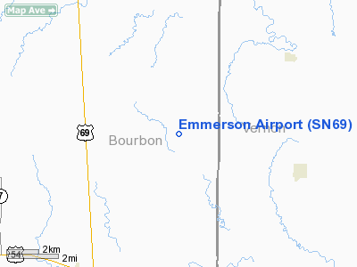
Emmerson Airport
Address:
Bourbon County, KS
Tel:
316-857-4499, 316-857-4498
Images
and information placed above are from
http://www.airport-data.com/airport/SN69/
We
thank them for the data!
|
General Info |
| Country |
United
States |
| State |
KANSAS
|
| FAA ID |
SN69
|
| Latitude |
37-55-53.135N |
|
Longitude |
094-38-33.850W |
|
Elevation |
860 feet
|
| Near
City |
HAMMOND
|
We don't guarantee the information is fresh and accurate. The data may
be wrong or outdated.
For more up-to-date information please refer to other sources.
|
|


