 |
|
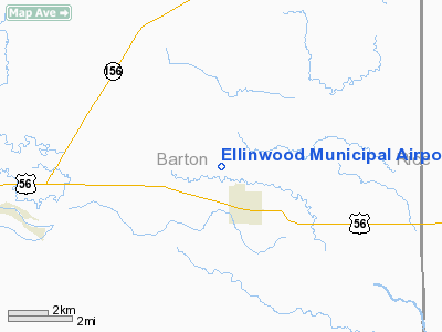
Ellinwood Municipal Airport |
|
|
|
Location &
QuickFacts
|
FAA
Information Effective: |
2008-06-05 |
|
Airport
Identifier: |
1K6 |
|
Airport
Status: |
Operational |
|
Longitude/Latitude: |
098-35-42.2790W/38-22-24.0420N
-98.595077/38.373345 (Estimated) |
|
Elevation: |
1797 ft / 547.73 m (Estimated) |
|
Land: |
45 acres |
|
From
nearest city: |
2 nautical miles NW of Ellinwood, KS |
|
Location: |
Barton County, KS |
|
Magnetic Variation: |
08E (1985) |
Owner & Manager
|
Ownership: |
Publicly owned |
|
Owner: |
City Ellinwood |
|
Address: |
Po Box 278
Ellinwood, KS 67526 |
|
Phone number: |
620-564-3161 |
|
Manager: |
Joe Vanhouten |
|
Address: |
Po Box 426
Ellinwood, KS 67526 |
|
Phone number: |
620-564-2508 |
Airport
Operations and Facilities
|
Airport
Use: |
Open to public |
|
Wind
indicator: |
Yes |
|
Segmented Circle: |
No |
|
Control
Tower: |
No |
|
Lighting
Schedule: |
DUSK-DAWN |
|
Landing
fee charge: |
No |
|
Sectional chart: |
Wichita |
|
Region: |
ACE - Central |
|
Boundary
ARTCC: |
ZKC - Kansas City |
|
Tie-in
FSS: |
ICT - Wichita |
|
FSS on
Airport: |
No |
|
FSS Toll
Free: |
1-800-WX-BRIEF |
|
NOTAMs
Facility: |
ICT (NOTAM-d service avaliable) |
Airport Communications
|
Runway Information
Runway 08/26
|
Dimension: |
2150 x 150 ft / 655.3 x 45.7 m |
|
Surface: |
TURF, Good Condition
VERY SOFT AFTER RAIN.
VERY SOFT AFTER RAIN. |
|
|
Runway 08
|
Runway 26
|
|
Traffic
Pattern: |
Left |
Left |
|
Obstruction: |
3 ft hill, 50.0 ft from runway, 16:1 slope to clear |
15 ft road, 420.0 ft from runway, 28:1 slope to clear |
|
Runway 17/35
|
Dimension: |
2550 x 100 ft / 777.2 x 30.5 m |
|
Surface: |
TURF, Good Condition
VERY SOFT AFTER RAIN.
VERY SOFT AFTER RAIN. |
|
Edge Lights: |
Low |
|
|
Runway 17
|
Runway 35
|
|
Longitude: |
098-35-55.3900W |
098-35-54.8400W |
|
Latitude: |
38-22-34.8300N |
38-22-09.6200N |
|
Traffic
Pattern: |
Left |
Left |
|
Obstruction: |
15 ft road, 40.0 ft from runway, 2:1 slope to clear |
, 50:1 slope to clear |
|
Radio Navigation Aids
|
ID |
Type |
Name |
Ch |
Freq |
Var |
Dist |
|
HIL |
NDB |
Hilyn |
|
338.00 |
08E |
14.5 nm |
|
LYO |
NDB |
Lyons |
|
386.00 |
06E |
17.4 nm |
|
LQR |
NDB |
Larned |
|
296.00 |
08E |
25.4 nm |
|
PTT |
NDB |
Pratt |
|
356.00 |
07E |
39.7 nm |
|
MPR |
NDB |
Mc Pherson |
|
227.00 |
06E |
42.8 nm |
|
HUT |
VOR/DME |
Hutchinson |
115X |
116.80 |
09E |
38.6 nm |
|
HYS |
VORTAC |
Hays |
041X |
110.40 |
10E |
42.9 nm |
Remarks
-
2 FT DITCH 200 FT
FM RY END.
-
ARPT CONSTRUCTED PRIOR TO
1959.
Based Aircraft
|
Aircraft based
on field: |
7 |
|
Single Engine
Airplanes: |
5 |
|
Ultralights: |
2 |
Operational Statistics
Time Period: 2005-12-13 - 2006-12-12
|
Aircraft
Operations: |
23/Week |
|
General
Aviation Local: |
87.0% |
|
General
Aviation Itinerant: |
13.0% |
Ellinwood Municipal Airport
Address:
Barton County, KS
Tel:
620-564-3161, 620-564-2508
Images
and information placed above are from
http://www.airport-data.com/airport/1K6/
We
thank them for the data!
|
General Info |
| Country |
United
States |
| State |
KANSAS
|
| FAA ID |
1K6
|
| Latitude |
38-22-24.042N |
|
Longitude |
098-35-42.279W |
|
Elevation |
1797
feet |
| Near
City |
ELLINWOOD |
We don't guarantee the information is fresh and accurate. The data may
be wrong or outdated.
For more up-to-date information please refer to other sources.
|
|


