 |
|
|
|
|
|
|
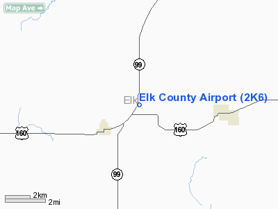
Location &
QuickFacts
|
FAA
Information Effective: |
2008-06-05 |
|
Airport
Identifier: |
2K6 |
|
Airport
Status: |
Operational |
|
Longitude/Latitude: |
096-16-14.9870W/37-22-50.1350N
-96.270830/37.380593 (Estimated) |
|
Elevation: |
1063 ft / 324.00 m (Estimated) |
|
Land: |
120 acres |
|
From
nearest city: |
3 nautical miles NE of Moline, KS |
|
Location: |
Elk County, KS |
|
Magnetic Variation: |
06E (1985) |
Owner & Manager
|
Ownership: |
Publicly owned |
|
Owner: |
Elk County |
|
Address: |
Courthouse
Howard, KS 67349 |
|
Phone number: |
620-374-2490 |
|
Manager: |
Kevin Kill |
|
Address: |
420 West 3rd
Moline, KS 67353 |
|
Phone number: |
620-647-3463 |
Airport
Operations and Facilities
|
Airport
Use: |
Open to public |
|
Wind
indicator: |
Yes |
|
Segmented Circle: |
No |
|
Control
Tower: |
No |
|
Landing
fee charge: |
No |
|
Sectional chart: |
Kansas City |
|
Region: |
ACE - Central |
|
Boundary
ARTCC: |
ZKC - Kansas City |
|
Tie-in
FSS: |
ICT - Wichita |
|
FSS on
Airport: |
No |
|
FSS Toll
Free: |
1-800-WX-BRIEF |
|
NOTAMs
Facility: |
ICT (NOTAM-d service avaliable) |
Airport Communications
Airport Services
|
Airframe
Repair: |
NONE |
|
Power
Plant Repair: |
NONE |
|
Runway Information
Runway 18/36
|
Dimension: |
2510 x 40 ft / 765.0 x 12.2 m |
|
Surface: |
ASPH, Poor Condition
PAVEMENT BADLY CRACKED WITH VEGETATION GROWING THROUGH CRACKS . |
|
|
Runway 18
|
Runway 36
|
|
Traffic
Pattern: |
Left |
Left |
|
Obstruction: |
52 ft pline, 1350.0 ft from runway, 22:1 slope to clear
+5' FENCE 34' RY END, 40' RIGHT AND 45' LEFT. |
41 ft pole, 245.0 ft from runway, 75 ft right of
centerline, 1:1 slope to clear
+15' ROAD AT THLD. |
|
Radio Navigation Aids
|
ID |
Type |
Name |
Ch |
Freq |
Var |
Dist |
|
EQA |
NDB |
El Dorado |
|
383.00 |
05E |
35.4 nm |
|
PPF |
NDB |
Parsons |
|
258.00 |
06E |
36.5 nm |
|
CFV |
NDB |
Coffeyville |
|
212.00 |
05E |
37.7 nm |
|
MSB |
NDB |
Monarch |
|
410.00 |
04E |
47.7 nm |
|
IAB |
TACAN |
Mc Connell |
112X |
|
07E |
49.7 nm |
|
BVO |
VOR/DME |
Bartlesville |
126X |
117.90 |
08E |
35.0 nm |
|
CNU |
VOR/DME |
Chanute |
029X |
109.20 |
05E |
35.5 nm |
Remarks
-
WILDLIFE ON & INVOF ARPT.
Based Aircraft
|
Aircraft based
on field: |
2 |
|
Single Engine
Airplanes: |
2 |
Operational Statistics
Time Period: 2006-08-31 - 2007-08-30
|
Aircraft
Operations: |
12/Week |
|
General
Aviation Local: |
100.0% |
Elk County Airport
Address:
Elk County, KS
Tel:
620-374-2490, 620-647-3463
Images
and information placed above are from
http://www.airport-data.com/airport/2K6/
We
thank them for the data!
|
General Info |
| Country |
United
States |
| State |
KANSAS
|
| FAA ID |
2K6
|
| Latitude |
37-22-50.135N |
|
Longitude |
096-16-14.987W |
|
Elevation |
1063
feet |
| Near
City |
MOLINE
|
We don't guarantee the information is fresh and accurate. The data may
be wrong or outdated.
For more up-to-date information please refer to other sources.
|
|


