 |
|
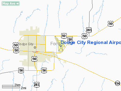
Dodge City Regional Airport |
| Dodge City Regional Airport |
 |
| IATA: DDC â ICAO: KDDC |
| Summary |
| Airport type |
Public |
| Operator |
Dodge City |
| Location |
Dodge City, Kansas |
| Elevation AMSL |
2,594 ft / 790.7 m |
| Coordinates |
37°45â²48â³N 99°57â²56â³W / 37.76333°N 99.96556°W / 37.76333; -99.96556Coordinates: 37°45â²48â³N 99°57â²56â³W / 37.76333°N 99.96556°W / 37.76333; -99.96556 |
| Runways |
| Direction |
Length |
Surface |
| ft |
m |
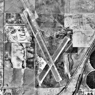
| 14/32 |
6,899 |
2,103 |
Asphalt |
| 2/20 |
4,649 |
1,417 |
Asphalt |
Dodge City Regional Airport (IATA: DDC, ICAO: KDDC) is a public airport located three miles (5 km) east of the central business district (CBD) of Dodge City, in Ford County, Kansas, USA. The airport covers 451 acres (183 ha) and has two runways. It is mostly used for general aviation, but is also served by one commercial airline. Service is subsidized by the Essential Air Service program.
Airlines and destinations
| Airlines |
Destinations |
| Great Lakes Airlines |
Denver, Kansas City |
The above content comes from Wikipedia and is published under free licenses – click here to read more.
|
Location &
QuickFacts
|
FAA
Information Effective: |
2008-06-05 |
|
Airport
Identifier: |
DDC |
|
Airport
Status: |
Operational |
|
Longitude/Latitude: |
099-57-55.5266W/37-45-47.2380N
-99.965424/37.763122 (Estimated) |
|
Elevation: |
2594 ft / 790.65 m (Surveyed) |
|
Land: |
451 acres |
|
From
nearest city: |
3 nautical miles E of Dodge City, KS |
|
Location: |
Ford County, KS |
|
Magnetic Variation: |
08E (1990) |
Owner & Manager
|
Ownership: |
Publicly owned |
|
Owner: |
City Of Dodge City |
|
Address: |
Po Box 880
Dodge City, KS 67801 |
|
Phone
number: |
620-225-8100 |
|
Manager: |
Mike Klein |
|
Address: |
100 Airport Rd
Dodge City, KS 67801 |
|
Phone number: |
620-225-8100 |
Airport Operations and Facilities
|
Airport
Use: |
Open to public |
|
Wind
indicator: |
Yes |
|
Segmented Circle: |
Yes |
|
Control
Tower: |
No |
|
Lighting
Schedule: |
DUSK-DAWN
ACTVT MIRL RYS 14/32 & 02/20 AND MALSR RY 14 AND VASI RYS 14 & 32 AND
REIL RYS 02; 20; AND 32 - CTAF. |
|
Beacon
Color: |
Clear-Green (lighted land airport) |
|
Landing
fee charge: |
No |
|
Sectional chart: |
Wichita |
|
Region: |
ACE - Central |
|
Boundary
ARTCC: |
ZKC - Kansas City |
|
Tie-in
FSS: |
ICT - Wichita |
|
FSS on
Airport: |
No |
|
FSS Toll
Free: |
1-800-WX-BRIEF |
|
NOTAMs
Facility: |
DDC (NOTAM-d service avaliable) |
|
Certification type/date: |
III A S 06/19
AS A CLASS III AIRPORT, ACR OPNS WITH MORE THAN 30 PSGR SEATS NOT
AUTHORIZED. |
|
Federal Agreements: |
NGY3 |
Airport Communications
|
CTAF: |
122.700 |
|
Unicom: |
122.700 |
Airport Services
|
Fuel
available: |
100LLA |
|
Airframe
Repair: |
MAJOR |
|
Power
Plant Repair: |
MAJOR |
|
Bottled
Oxygen: |
NONE |
|
Bulk
Oxygen: |
LOW |
|
Runway Information
Runway 02/20
|
Dimension: |
4649 x 100 ft / 1417.0 x 30.5 m |
|
Surface: |
ASPH, Good Condition |
|
Weight Limit: |
Single wheel: 19000 lbs.
Dual wheel: 24000 lbs. |
|
Edge Lights: |
Medium |
|
|
Runway 02
|
Runway 20
|
|
Longitude: |
099-58-03.8910W |
099-57-32.9250W |
|
Latitude: |
37-45-19.6090N |
37-45-58.4320N |
|
Elevation: |
2594.00 ft |
2562.00 ft |
|
Alignment: |
32 |
127 |
|
Traffic
Pattern: |
Left |
Left |
|
Markings: |
Non-precision instrument, Fair Condition |
Non-precision instrument, Fair Condition |
|
Runway End
Identifier: |
Yes |
Yes |
|
Decleard
distances: |
Take off run available 4649.00 ft
Take off distance available 4649.00 ft
Actual stop distance available 4649.00 ft
Landing distance available 4649.00 ft |
Take off run available 4649.00 ft
Take off distance available 4649.00 ft
Actual stop distance available 4649.00 ft
Landing distance available 4649.00 ft |
|
Runway 14/32
|
Dimension: |
6899 x 100 ft / 2102.8 x 30.5 m |
|
Surface: |
ASPH, Good Condition |
|
Weight Limit: |
Single wheel: 40000 lbs.
Dual wheel: 53000 lbs. |
|
Edge Lights: |
Medium |
|
|
Runway 14
|
Runway 32
|
|
Longitude: |
099-58-19.2660W |
099-57-41.3810W |
|
Latitude: |
37-46-23.3800N |
37-45-22.1710N |
|
Elevation: |
2583.00 ft |
2586.00 ft |
|
Alignment: |
127 |
127 |
|
ILS Type: |
ILS |
|
|
Traffic
Pattern: |
Left |
Left |
|
Markings: |
Precision instrument, Good Condition |
Precision instrument, Good Condition |
|
Crossing
Height: |
37.00 ft |
40.00 ft |
|
Displaced
threshold: |
0.00 ft |
570.00 ft |
|
VASI: |
4-box on left side |
4-box on left side |
|
Visual
Glide Angle: |
3.00° |
3.00° |
|
Approach
lights: |
MALSR |
|
|
Runway End
Identifier: |
|
Yes |
|
Decleard
distances: |
Take off run available 6899.00 ft
Take off distance available 6899.00 ft
Actual stop distance available 6329.00 ft
Landing distance available 6329.00 ft |
Take off run available 6899.00 ft
Take off distance available 6899.00 ft
Actual stop distance available 6899.00 ft
Landing distance available 6329.00 ft |
|
Radio Navigation Aids
|
ID |
Type |
Name |
Ch |
Freq |
Var |
Dist |
|
MEJ |
NDB |
Meade |
|
389.00 |
09E |
34.3 nm |
|
GC |
NDB |
Pieve |
|
347.00 |
09E |
36.3 nm |
|
LQR |
NDB |
Larned |
|
296.00 |
08E |
49.3 nm |
|
DDC |
VORTAC |
Dodge City |
019X |
108.20 |
08E |
5.6 nm |
|
GCK |
VORTAC |
Garden City |
080X |
113.30 |
11E |
37.3 nm |
Based Aircraft
|
Aircraft based
on field: |
40 |
|
Single Engine
Airplanes: |
31 |
|
Multi Engine
Airplanes: |
8 |
|
Helicopters: |
1 |
Operational Statistics
Time Period: 2007-02-01 - 2008-01-31
|
Aircraft
Operations: |
65/Day |
|
Commerical: |
16.2% |
|
Air Taxi: |
6.4% |
|
General
Aviation Local: |
51.1% |
|
General
Aviation Itinerant: |
25.5% |
|
Military: |
0.9% |
Dodge City Regional Airport
Address:
Ford County, KS
Tel:
620-225-8100
Images
and information placed above are from
http://www.airport-data.com/airport/DDC/
We
thank them for the data!
|
General Info |
| Country |
United
States |
| State |
KANSAS
|
| FAA ID |
DDC
|
| Latitude |
37-45-48.407N |
|
Longitude |
099-57-56.179W |
|
Elevation |
2594
feet |
| Near
City |
DODGE
CITY |
We don't guarantee the information is fresh and accurate. The data may
be wrong or outdated.
For more up-to-date information please refer to other sources.
|
|


