 |
|
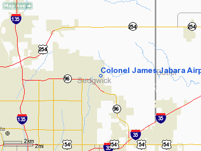
Colonel James Jabara Airport |
| Colonel James Jabara Airport |
| IATA: none â ICAO: KAAO â FAA LID: AAO |
| Summary |
| Airport type |
Public |
| Owner |
Wichita Airport Authority |
| Location |
Wichita, Kansas |
| Elevation AMSL |
1,421 ft / 433 m |
| Coordinates |
37°44â²51â³N 097°13â²16â³W / 37.7475°N 97.22111°W / 37.7475; -97.22111 |
| Runways |
| Direction |
Length |
Surface |
| ft |
m |
| 18/36 |
6,101 |
1,860 |
Concrete |
| Helipads |
| Number |
Length |
Surface |
| ft |
m |
| H1 |
50 |
15 |
Concrete |
| Statistics (2006) |
| Aircraft operations |
38,300 |
| Based aircraft |
108 |
| Source: Federal Aviation Administration |
Colonel James Jabara Airport (ICAO: KAAO, FAA LID: AAO) is a public airport located nine miles (14 km) northeast of the central business district of Wichita, a city in Sedgwick County, Kansas, United States. It is named in honor of World War II and Korean War flying ace James Jabara, an American of Lebanese descent who has the distinction of being the first American jet ace.
Although most U.S. airports use the same three-letter location identifier for the FAA and IATA, Colonel James Jabara Airport is assigned AAO by the FAA but has no designation from the IATA (which assigned AAO to Anaco, Venezuela). The airport's ICAO identifier is KAAO.
Facilities and aircraft
Colonel James Jabara Airport covers an area of 600 acres (243 ha) which contains one runway and one helipad:
- Runway 18/36: 6,101 x 100 ft (1,860 x 30 m), Surface: Concrete
- Helipad H1: 50 x 50 ft (15 x 15 m), Surface: Concrete
For 12-month period ending May 31, 2006, the airport had 38,300 aircraft operations, an average of 104 per day: 97% general aviation and 3% air taxi. There are 108 aircraft based at this airport: 60% single engine, 28% multi-engine, 9% jet aircraft, 1% helicopters, 1% ultralights and 1% military.
The above content comes from Wikipedia and is published under free licenses – click here to read more.
|
Location &
QuickFacts
|
FAA
Information Effective: |
2008-06-05 |
|
Airport
Identifier: |
AAO |
|
Airport
Status: |
Operational |
|
Longitude/Latitude: |
097-13-16.0000W/37-44-51.3000N
-97.221111/37.747583 (Estimated) |
|
Elevation: |
1421 ft / 433.12 m (Surveyed) |
|
Land: |
600 acres |
|
From
nearest city: |
9 nautical miles NE of Wichita, KS |
|
Location: |
Sedgwick County, KS |
|
Magnetic Variation: |
06E (2000) |
Owner & Manager
|
Ownership: |
Publicly owned |
|
Owner: |
Wichita Airport Authority |
|
Address: |
2173 Air Cargo Rd
Wichita, KS 67209 |
|
Phone
number: |
316-946-4700 |
|
Manager: |
Victor White |
|
Address: |
Wichita Arpt Authority, 2173 Air Cargo Rd
Wichita, KS 67209 |
|
Phone number: |
316-946-4700 |
Airport Operations and Facilities
|
Airport
Use: |
Open to public |
|
Wind
indicator: |
Yes |
|
Segmented Circle: |
Yes |
|
Control
Tower: |
No |
|
Lighting
Schedule: |
DUSK-DAWN
ACTVT PAPI RYS 18 & 36 - CTAF. |
|
Beacon
Color: |
Clear-Green (lighted land airport) |
|
Landing
fee charge: |
No |
|
Sectional chart: |
Wichita |
|
Region: |
ACE - Central |
|
Traffic
Pattern Alt: |
800 ft |
|
Boundary
ARTCC: |
ZKC - Kansas City |
|
Tie-in
FSS: |
ICT - Wichita |
|
FSS on
Airport: |
No |
|
FSS Toll
Free: |
1-800-WX-BRIEF |
|
NOTAMs
Facility: |
AAO (NOTAM-d service avaliable) |
|
Federal Agreements: |
NGY |
Airport Communications
|
CTAF: |
122.700 |
|
Unicom: |
122.700 |
Airport Services
|
Fuel
available: |
100LLA |
|
Airframe
Repair: |
MAJOR |
|
Power
Plant Repair: |
MAJOR |
|
Bottled
Oxygen: |
NONE |
|
Bulk
Oxygen: |
NONE |
|
Runway Information
Runway 18/36
|
Dimension: |
6101 x 100 ft / 1859.6 x 30.5 m |
|
Surface: |
CONC, Good Condition |
|
Surface
Treatment: |
Saw-cut or plastic Grooved |
|
Weight Limit: |
Single wheel: 40000 lbs.
Dual wheel: 62000 lbs. |
|
Edge Lights: |
Medium
PERIMETER LGTS. |
|
|
Runway 18
|
Runway 36
|
|
Longitude: |
097-13-11.5042W |
097-13-20.5451W |
|
Latitude: |
37-45-21.2030N |
37-44-21.3254N |
|
Elevation: |
1401.00 ft |
1421.00 ft |
|
Alignment: |
127 |
7 |
|
ILS Type: |
ILS/DME |
|
|
Traffic
Pattern: |
Right |
Left |
|
Markings: |
Precision instrument, Good Condition |
Non-precision instrument, Good Condition |
|
Crossing
Height: |
34.00 ft |
45.00 ft |
|
VASI: |
4-light PAPI on left side |
4-light PAPI on left side |
|
Visual
Glide Angle: |
3.00° |
3.00° |
|
Approach
lights: |
MALSR |
|
|
Runway End
Identifier: |
No |
Yes |
|
Helipad H1
|
Dimension: |
50 x 50 ft / 15.2 x 15.2 m |
|
Surface: |
CONC, Good Condition |
|
Edge Lights: |
Medium
PERIMETER LGTS. |
|
|
Runway H1
|
Runway
|
|
Traffic
Pattern: |
Left |
Left |
|
Radio Navigation Aids
|
ID |
Type |
Name |
Ch |
Freq |
Var |
Dist |
|
IC |
NDB |
Piche |
|
332.00 |
07E |
15.1 nm |
|
EWK |
NDB |
Newton |
|
281.00 |
06E |
19.2 nm |
|
EQA |
NDB |
El Dorado |
|
383.00 |
05E |
19.3 nm |
|
EGT |
NDB |
Wellington |
|
414.00 |
07E |
26.7 nm |
|
MPR |
NDB |
Mc Pherson |
|
227.00 |
06E |
42.3 nm |
|
IAB |
TACAN |
Mc Connell |
112X |
|
07E |
7.9 nm |
|
HUT |
VOR/DME |
Hutchinson |
115X |
116.80 |
09E |
37.0 nm |
|
ICT |
VORTAC |
Wichita |
085X |
113.80 |
07E |
17.2 nm |
|
ICT |
VOT |
Wichita |
|
114.00 |
|
12.1 nm |
Remarks
-
NOISE SENSITIVE
AREAS TO THE SOUTH & WEST.
-
MIGRATORY BIRDS
ON & INVOF ARPT.
-
PPR REQUIRED FOR
ACFT CARRYING CLASS 1 - DIVISION 1.1; 1.2 OR 1.3 EXPLOSIVES AS DEFINED BY 49
CFR 173.50.
-
VFR ARRIVALS FM
E/SE CTC BEECH ATCT ON FREQ 126.80 FOR BEECH FACTORY ARPT TFC ADVISORIES.
-
BE ALERT FOR
MILITARY ACFT W OF FIELD AT 3000 FT.
-
RY 18 VFR DEPS
MAKE RIGHT DOWNWIND DEP.
-
DUE TO RY & TWY
END ELEVATION DIFFERENTIALS & ACFT HGT, PILOTS MAY LOSE LINE OF SIGHT OF OTHER
ACFT ON OPPOSING RY & TWY ENDS.
-
CAUTION: OBSERVE
PUBLISHED TRAFFIC PATTERNS, BEECH FACTORY FLD RY 18 FINAL ONLY ONE MILE TO THE
EAST.
-
RWY 18/36 HAS NO
OBJECTION; HELIPAD MUST MAINT CLEAR APP/DEP PATHS FOR 8:1 GLIDE SLOPE AND
TRSNL SFC FOR A 2:1 SLOPE.
Based Aircraft
|
Aircraft based
on field: |
108 |
|
Single Engine
Airplanes: |
65 |
|
Multi Engine
Airplanes: |
30 |
|
Jet Engine
Airplanes: |
10 |
|
Helicopters: |
1 |
|
Military: |
1 |
|
Ultralights: |
1 |
Operational Statistics
Time Period: 2005-06-01 - 2006-05-31
|
Aircraft
Operations: |
105/Day |
|
Air Taxi: |
3.4% |
|
General
Aviation Local: |
47.0% |
|
General
Aviation Itinerant: |
49.6% |
Colonel James Jabara Airport
Address:
Sedgwick County, KS
Tel:
316-946-4700
Images
and information placed above are from
http://www.airport-data.com/airport/AAO/
We
thank them for the data!
|
General Info |
| Country |
United
States |
| State |
KANSAS
|
| FAA ID |
AAO
|
| Latitude |
37-44-51.200N |
|
Longitude |
097-13-16.100W |
|
Elevation |
1420
feet |
| Near
City |
WICHITA
|
We don't guarantee the information is fresh and accurate. The data may
be wrong or outdated.
For more up-to-date information please refer to other sources.
|
|


