|
|
Coffeyville Municipal Airport |
Coordinates: 37°05â²39â³N 095°34â²19â³W / 37.09417°N 95.57194°W / 37.09417; -95.57194
| Coffeyville Municipal Airport |
 |
| IATA: CFV â ICAO: KCFV â FAA LID: CFV |
| Summary |
| Airport type |
Public |
| Owner |
City of Coffeyville |
| Serves |
Coffeyville, Kansas |
| Location |
Cherokee Township, Montgomery County, near Coffeyville, Kansas |
| Elevation AMSL |
754 ft / 230 m |
| Runways |
| Direction |
Length |
Surface |
| ft |
m |
| 17/35 |
5,872 |
1,790 |
Asphalt |
| 4/22 |
4,000 |
1,219 |
Asphalt |
| Statistics (2005) |
| Aircraft operations |
5,550 |
| Based aircraft |
40 |
| Source: Federal Aviation Administration |
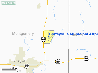
Coffeyville Municipal Airport (IATA: CFV, ICAO: KCFV, FAA LID: CFV) is a city-owned public-use airport located four miles (6 km) northeast of the central business district of Coffeyville, a city in Montgomery County, Kansas, United States. History
During World War II, the facility was known as Coffeyville Army Airfield and was used as a United States Army Air Forces AAF Flying Training Command training field from 1942 though 1945. The 366th Army Air Force Base Unit (366th AAFBU) was the host unit at the airfield which performed Basic Pilot School instruction for aviation cadets.
Aircraft operated were Vultee BT-13A Valiants, BT-14s and BT-15s. The difference being that the BT-14 and BT-15 had more powerful engines. The BT-13 was the basic trainer flown by most pilots during WWII. It was the second phase of the three phase training program for pilots.
Coffeyville AAF also operated 4 auxiliary airfields in the area. The facility was closed and turned over to civil authorities at the end of the war and it was turned into a civil airport.
Facilities and aircraft
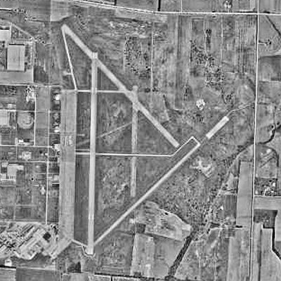
Coffeyville Municipal Airport covers an area of 1,227 acres (497 ha) which contains two asphalt paved runways: 17/35 measuring 5,872 x 100 ft (1,790 x 30 m) and 4/22 measuring 4,000 x 75 ft (1,219 x 23 m).
For the 12-month period ending September 19, 2005, the airport had 5,550 aircraft operations, an average of 15 per day: 99% general aviation and 1% military. At that time there were 40 aircraft based at this airport: 85% single-engine, 10% multi-engine and 5% ultralight.
The above content comes from Wikipedia and is published under free licenses – click here to read more.
|
Location &
QuickFacts
|
FAA
Information Effective: |
2008-06-05 |
|
Airport
Identifier: |
CFV |
|
Airport
Status: |
Operational |
|
Longitude/Latitude: |
095-34-18.8190W/37-05-38.5710N
-95.571894/37.094048 (Estimated) |
|
Elevation: |
754 ft / 229.82 m (Surveyed) |
|
Land: |
1227 acres |
|
From
nearest city: |
4 nautical miles NE of Coffeyville, KS |
|
Location: |
Montgomery County, KS |
|
Magnetic Variation: |
05E (1995) |
Owner & Manager
|
Ownership: |
Publicly owned |
|
Owner: |
City Of Coffeyville |
|
Address: |
City Hall
Coffeyville, KS 67337 |
|
Phone number: |
620-252-6137 |
|
Manager: |
Bob Ingmire |
|
Address: |
Box 1629
Coffeyville, KS 67337 |
|
Phone number: |
620-252-6192 |
Airport
Operations and Facilities
|
Airport
Use: |
Open to public |
|
Wind
indicator: |
Yes |
|
Segmented Circle: |
No |
|
Control
Tower: |
No |
|
Lighting
Schedule: |
DUSK-DAWN
ACTVT MIRL RY 17/35; REIL RY 35; VASI RY 17 & 35 - CTAF. |
|
Beacon
Color: |
Clear-Green (lighted land airport) |
|
Landing
fee charge: |
No |
|
Sectional chart: |
Kansas City |
|
Region: |
ACE - Central |
|
Boundary
ARTCC: |
ZKC - Kansas City |
|
Tie-in
FSS: |
ICT - Wichita |
|
FSS on
Airport: |
No |
|
FSS Toll
Free: |
1-800-WX-BRIEF |
|
NOTAMs
Facility: |
CFV (NOTAM-d service avaliable) |
|
Federal Agreements: |
NGPRY |
Airport Communications
|
CTAF: |
123.000 |
|
Unicom: |
123.000 |
Airport Services
|
Fuel
available: |
100LLA |
|
Airframe
Repair: |
MAJOR |
|
Power
Plant Repair: |
MAJOR |
|
Bottled
Oxygen: |
HIGH |
|
Bulk
Oxygen: |
NONE |
|
Runway Information
Runway 04/22
|
Dimension: |
4000 x 75 ft / 1219.2 x 22.9 m |
|
Surface: |
ASPH, Good Condition
VEGETATION GROWING THRU PAVEMENT JOINTS. |
|
|
Runway 04
|
Runway 22
|
|
Alignment: |
45 |
127 |
|
Traffic
Pattern: |
Left |
Left |
|
Markings: |
Basic, Good Condition |
Basic, Good Condition |
|
Obstruction: |
, 50:1 slope to clear |
28 ft tree, 418.0 ft from runway, 194 ft left of
centerline, 8:1 slope to clear |
|
Runway 17/35
|
Dimension: |
5872 x 100 ft / 1789.8 x 30.5 m |
|
Surface: |
ASPH, Good Condition
VEGETATION GROWING THRU PAVEMENT JOINTS. |
|
Weight Limit: |
Single wheel: 20000 lbs.
Dual wheel: 25000 lbs. |
|
Edge Lights: |
Medium |
|
|
Runway 17
|
Runway 35
|
|
Longitude: |
095-34-27.7810W |
095-34-27.5660W |
|
Latitude: |
37-06-11.6540N |
37-05-13.6480N |
|
Elevation: |
745.00 ft |
742.00 ft |
|
Alignment: |
127 |
127 |
|
Traffic
Pattern: |
Left |
Left |
|
Markings: |
Non-precision instrument, Good Condition |
Non-precision instrument, Good Condition |
|
Crossing
Height: |
51.00 ft |
53.00 ft |
|
VASI: |
2-box on right side |
2-box on left side |
|
Visual
Glide Angle: |
3.00° |
3.00° |
|
Runway End
Identifier: |
No |
Yes |
|
Centerline
Lights: |
No |
No |
|
Touchdown
Lights: |
No |
No |
|
Radio Navigation Aids
|
ID |
Type |
Name |
Ch |
Freq |
Var |
Dist |
|
PPF |
NDB |
Parsons |
|
258.00 |
06E |
15.0 nm |
|
MSB |
NDB |
Monarch |
|
410.00 |
04E |
42.6 nm |
|
PTS |
NDB |
Pittsburg |
|
365.00 |
05E |
45.5 nm |
|
DW |
NDB |
Owaso |
|
375.00 |
06E |
49.5 nm |
|
BVO |
VOR/DME |
Bartlesville |
126X |
117.90 |
08E |
26.5 nm |
|
CNU |
VOR/DME |
Chanute |
029X |
109.20 |
05E |
32.0 nm |
|
OSW |
VORTAC |
Oswego |
123X |
117.60 |
08E |
18.1 nm |
Remarks
-
DEER ON & INVOF ARPT.
-
(A330-4) SLURRY SEAL.
-
MOWERS ON & INVOF
RYS DUSK-DAWN.
Based Aircraft
|
Aircraft based
on field: |
40 |
|
Single Engine
Airplanes: |
34 |
|
Multi Engine
Airplanes: |
4 |
|
Ultralights: |
2 |
Operational Statistics
Time Period: 2004-09-20 - 2005-09-19
|
Aircraft
Operations: |
107/Week |
|
General
Aviation Local: |
72.1% |
|
General
Aviation Itinerant: |
27.0% |
|
Military: |
0.9% |
Coffeyville Municipal Airport
Address:
Montgomery County, KS
Tel:
620-252-6137, 620-252-6192
Images
and information placed above are from
http://www.airport-data.com/airport/CFV/
We
thank them for the data!
|
General Info |
| Country |
United
States |
| State |
KANSAS
|
| FAA ID |
CFV
|
| Latitude |
37-05-38.571N |
|
Longitude |
095-34-18.819W |
|
Elevation |
754 feet
|
| Near
City |
COFFEYVILLE |
We don't guarantee the information is fresh and accurate. The data may
be wrong or outdated.
For more up-to-date information please refer to other sources.
|
|