 |
|
Coordinates: 38°18â²09â³N 095°43â²30â³W / 38.3025°N 95.725°W / 38.3025; -95.725
| Coffey County Airport |
| IATA: none â ICAO: KUKL â FAA LID: UKL |
| Summary |
| Airport type |
Public |
| Owner |
County of Coffey |
| Serves |
Burlington, Kansas |
| Elevation AMSL |
1,173 ft / 358 m |
| Runways |
| Direction |
Length |
Surface |
| ft |
m |
| 18/36 |
5,500 |
1,676 |
Concrete |
| Statistics (2005) |
| Aircraft operations |
20,050 |
| Based aircraft |
32 |
| Source: Federal Aviation Administration |
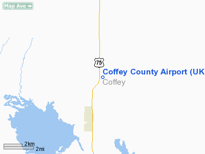
Coffey County Airport (ICAO: KUKL, FAA LID: UKL) is a county-owned public-use airport located seven miles (11 km) north of the central business district of Burlington, a city in Coffey County, Kansas, United States.
Although most U.S. airports use the same three-letter location identifier for the FAA and IATA, Coffey County Airport is assigned UKL by the FAA but has no designation from the IATA.
Facilities and aircraft
Coffey County Airport covers an area of 960 acres (388 ha) which contains one concrete paved runway (18/36) measuring 5,500 x 75 ft (1,676 x 23 m). For the 12-month period ending September 9, 2005, the airport had 20,050 aircraft operations, an average of 54 per day: 99.8% general aviation and 0.2% military. At that time there were 32 aircraft based at this airport: 88% single-engine, 3% multi-engine and 9% ultralight.
The above content comes from Wikipedia and is published under free licenses – click here to read more.
|
Location &
QuickFacts
|
FAA
Information Effective: |
2008-06-05 |
|
Airport
Identifier: |
UKL |
|
Airport
Status: |
Operational |
|
Longitude/Latitude: |
095-43-29.8470W/38-18-08.9450N
-95.724958/38.302485 (Estimated) |
|
Elevation: |
1173 ft / 357.53 m (Surveyed) |
|
Land: |
960 acres |
|
From
nearest city: |
7 nautical miles N of Burlington, KS |
|
Location: |
Coffey County, KS |
|
Magnetic Variation: |
05E (2000) |
Owner & Manager
|
Ownership: |
Publicly owned |
|
Owner: |
County Of Coffey
HERBERT HOOD, CHAIRMAN ARPT CMSN - LEROY, KS 66857. |
|
Address: |
6th & Neosho
Burlington, KS 66839 |
|
Phone number: |
620-364-2191 |
|
Manager: |
Darren Isch |
|
Address: |
1899 Hwy 75
Burlington, KS 66839 |
|
Phone number: |
620-364-5346 |
Airport
Operations and Facilities
|
Airport
Use: |
Open to public |
|
Wind
indicator: |
Yes
FADED |
|
Segmented Circle: |
Yes |
|
Control
Tower: |
No |
|
Lighting
Schedule: |
DUSK-DAWN
MIRL RY 18/36 OPERS DUSK-2200. AFT 2200 ACTVT MIRL RY 18/36 & PAPI RY
18 - CTAF. |
|
Beacon
Color: |
Clear-Green (lighted land airport) |
|
Sectional chart: |
Kansas City |
|
Region: |
ACE - Central |
|
Boundary
ARTCC: |
ZKC - Kansas City |
|
Tie-in
FSS: |
ICT - Wichita |
|
FSS Toll
Free: |
1-800-WX-BRIEF |
|
NOTAMs
Facility: |
ICT (NOTAM-d service avaliable) |
|
Federal Agreements: |
N |
Airport Communications
|
CTAF: |
123.000 |
|
Unicom: |
123.000 |
Airport Services
|
Fuel
available: |
100LLA |
|
Airframe
Repair: |
MAJOR |
|
Power
Plant Repair: |
MAJOR |
|
Runway Information
Runway 18/36
|
Dimension: |
5500 x 75 ft / 1676.4 x 22.9 m |
|
Surface: |
CONC, Good Condition |
|
Weight Limit: |
Single wheel: 30000 lbs. |
|
Edge Lights: |
Medium |
|
|
Runway 18
|
Runway 36
|
|
Longitude: |
095-43-30.0260W |
095-43-29.6650W |
|
Latitude: |
38-18-36.1290N |
38-17-41.7610N |
|
Elevation: |
1171.00 ft |
1169.00 ft |
|
Alignment: |
127 |
127 |
|
Traffic
Pattern: |
Left |
Left |
|
Markings: |
Non-precision instrument, Good Condition |
Non-precision instrument, Good Condition |
|
VASI: |
4-light PAPI on left side |
|
|
Obstruction: |
55 ft tree, 2640.0 ft from runway, 50 ft right of
centerline, 44:1 slope to clear |
, 50:1 slope to clear |
|
Radio Navigation Aids
|
ID |
Type |
Name |
Ch |
Freq |
Var |
Dist |
|
UKL |
NDB |
Boyd |
|
245.00 |
05E |
0.2 nm |
|
MSB |
NDB |
Monarch |
|
410.00 |
04E |
34.0 nm |
|
TO |
NDB |
Biloy |
|
521.00 |
05E |
49.2 nm |
|
FOE |
TACAN |
Forbes |
053X |
|
05E |
38.9 nm |
|
CNU |
VOR/DME |
Chanute |
029X |
109.20 |
05E |
41.1 nm |
|
EMP |
VORTAC |
Emporia |
075X |
112.80 |
08E |
19.5 nm |
|
FOE |
VOT |
Forbes |
|
111.00 |
|
39.1 nm |
Remarks
-
ULTRALIGHT ACTVTY
ON & INVOF ARPT.
-
PRVDD THE APCH TO
EACH RY THR IS CLEAR TO 20:1 AND TRANSITIONAL SFCS ARE CLEAR TO 7:1.
Based Aircraft
|
Aircraft based
on field: |
32 |
|
Single Engine
Airplanes: |
28 |
|
Multi Engine
Airplanes: |
1 |
|
Ultralights: |
3 |
Operational Statistics
Time Period: 2004-09-10 - 2005-09-09
|
Aircraft
Operations: |
55/Day |
|
General
Aviation Local: |
59.9% |
|
General
Aviation Itinerant: |
39.9% |
|
Military: |
0.2% |
Coffey County Airport
Address:
Coffey County, KS
Tel:
620-364-2191, 620-364-5346
Images
and information placed above are from
http://www.airport-data.com/airport/UKL/
We
thank them for the data!
|
General Info |
| Country |
United
States |
| State |
KANSAS
|
| FAA ID |
UKL
|
| Latitude |
38-18-08.945N |
|
Longitude |
095-43-29.847W |
|
Elevation |
1173
feet |
| Near
City |
BURLINGTON |
We don't guarantee the information is fresh and accurate. The data may
be wrong or outdated.
For more up-to-date information please refer to other sources.
|
|


